Abstract
Groundwater is a critical resource in Nigeria, particularly within the crystalline basement complex terrains that underlie much of the country, where its occurrence is constrained to secondary fractures and weathered layers. This study presents an integrated geophysical survey combining Vertical Electrical Sounding (VES) and Frequency-Domain Electromagnetic (FEM) methods to delineate aquifer zones and identify an optimal borehole drilling site at a property in Asokoro, Abuja. The VES data, acquired using a Schlumberger array, revealed varying geoelectric sequences: a promising three-layer QHK-type curve at VES 1 indicating a deep weathering profile and a fractured aquifer, an unfavorable AA-type curve at VES 2 suggesting massive impermeable bedrock, and a highly favorable HKH-type curve at VES 3 signifying a well-developed, water- saturated fracture zone. To overcome site constraints and map lateral continuity, an EM survey was conducted, confirming a low resistivity anomaly indicative of a saturated fractured zone at depths of 120-150 m. Interpretation of the integrated data suggests a moderately low groundwater yield potential, with the aquifer confined within fractured basement rock. It is recommended to drill at the identified point to a depth of 140-150 meters to tap into the identified fractured aquifer unit, which is expected to function as a natural reservoir.
|
Published in
|
Science Research (Volume 14, Issue 2)
|
|
DOI
|
10.11648/j.sr.20261402.14
|
|
Page(s)
|
56-61 |
|
Creative Commons
|

This is an Open Access article, distributed under the terms of the Creative Commons Attribution 4.0 International License (http://creativecommons.org/licenses/by/4.0/), which permits unrestricted use, distribution and reproduction in any medium or format, provided the original work is properly cited.
|
|
Copyright
|
Copyright © The Author(s), 2026. Published by Science Publishing Group
|
Keywords
Groundwater Exploration, Vertical Electrical Sounding, Electromagnetic Survey, Basement Complex, Aquifer Delineation, Asokoro, Geophysics
1. Introduction
Groundwater serves as the primary source of potable water for over 60% of Nigeria's population, proving vital for domestic, agricultural, and industrial uses due to its reliability compared to seasonally variable and often polluted surface water sources
| [1] | Adiat, K. A. N., Ajayi, O. F., & Akinlalu, A. A. A., 2020. Prediction of groundwater level in basement complex terrain using artificial neural network: a case of Ijebu-Jesa, southwestern Nigeria. Applied Water Science, 10, 149.
https://doi.org/10.1007/s13201-019-1094-6 |
[1]
. The quest for sustainable groundwater development requires precise geophysical investigations to identify viable aquifers, especially within the Precambrian crystalline basement rocks that underlie about half of Nigeria's territory, including the Federal Capital Territory (FCT), Abuja
| [2] | Anonymous, 2023. Geology and petrography of the basement complex rocks of Tsauni area and environs, Gwagwalada, Abuja FCT. International Journal of Geology and Earth Science, 10(1), 21-37. https://doi.org/10.18178/ijges.10.1.21-37 |
| [11] | Omada, J. I., & Obayomi, O. O., 2013. An assessment of groundwater resources in basement complex terrain of Gwarinpa-Kafe area of Abuja Metropolis, Central Nigeria. Primescholars. |
[2, 11]
. In these terrains, groundwater occurrence is not inherent in the rock matrix but is confined to secondary porosity developed through weathering and fracturing, creating complex aquifer systems
| [3] | Ayuba, R., Omonona, O. V., & Onwuka, O. S., 2013. Assessment of groundwater quality of Lokoja basement area, North-Central Nigeria. Journal of the Geological Society of India, 82, 413-420. https://doi.org/10.1007/s12594-013-0168-6 |
[3]
.
The high spatial heterogeneity, variable fracture connectivity and localized recharge make hydrogeological assessment in basement terrains particularly challenging (e.g.,
). This study focuses on a site in Asokoro, Abuja, located within the basement complex terrain, with the objective of characterizing subsurface geoelectric layers via integrated geophysical methods (Vertical Electrical Sounding and Frequency-Domain Electromagnetic) to evaluate groundwater potential and determine an optimal borehole location. The investigation aims to determine the precise drilling spot and depth, recommend appropriate drilling methodology (e.g., mud rotary for sedimentary overburden or air hammer for basement rock), and provide an anticipatory yield classification based on geophysical signatures. The adoption of an integrated approach (VES + EM) is crucial in such almost impermeable crystalline terrains where single-method surveys often fall short in capturing lateral and vertical heterogeneity
| [5] | Ebele, J. E., et al., 2024. Integrated groundwater exploration in basement complex terrain. Journal of Earth Science & Environmental Studies, 9, 64. https://doi.org/10.2352801X2400064X |
[5]
. Furthermore, the dwell of the zone in a region of increasing population and water demand underscores the need for optimal borehole siting to avoid costly failures. Moreover, given the rapid urbanization of Abuja and the increasing surface sealing (roads, pavements) and changing land-use, recharge conditions are altered, potentially reducing groundwater replenishment.
Recent studies also highlight vulnerability of basement complex aquifers to contamination (e.g., nitrate intrusion) in the Abuja area
| [6] | Etuk, M. N., Lartsey, P. E. S., Maduka, R., Ayogu, C. N., & Ogbonnaya, I., 2025. Comparative study of DRASTIC-LU and radioactive isotope approaches for assessing groundwater vulnerability to pollution: the case study of Abuja, North Central Nigeria. Hydrogeology Journal, 33, 1-14.
https://doi.org/10.1007/s43832-025-00191-4 |
[6]
. In view of these considerations, this study contributes to the body of knowledge by providing an updated geophysical assessment of groundwater potential in a basement terrain in Asokoro, thereby aiding sustainable water resource development in a rapidly urbanizing context
.
2. Materials and Methods
2.1. Study Area and Geological Setting
2.1.1. Location and Climate / Rainfall
The study area lies within the Asokoro district of Abuja, north-central Nigeria (approximate coordinates: 09°02′N, 07°30′E), at an elevation around 585 m above mean sea level. The climate is characterized by a distinct wet season (roughly April to October) and a dry season (November to March). Mean annual rainfall for the Abuja FCT is typically in the range of ~1,100 to 1,400 mm, with peak rainfall usually occurring between July and September. Recharge to the basement aquifer system is therefore strongly seasonal, with infiltration during the wet season (sometimes aided by fractures and weathered overburden) limited input in the long dry season. In basement complex terrains such as this, the thickness of the weathered zone, fracture connectivity and recharge through the overburden become the controlling factors of aquifer development — and seasonal rainfall variability and land-use change further complicate the picture
.
2.1.2. Geological Setting
The study area lies within the north-central sector of the Nigerian Basement Complex, part of the larger Pan-African orogenic belt
| [15] | Tijani, M. N., 2023. Geology of Nigeria Precambrian basement complex, sedimentary rocks, Cretaceous & Quaternary alluvial deposit. In: Faniran, A., et al. (Eds.), Landscapes and Landforms of Nigeria, Springer, Cham, pp. 1-35.
https://doi.org/10.1007/978-3-031-17972-3_1 |
[15]
. The local lithology comprises migmatites, banded gneisses and granites, with later Pan-African granitic intrusions. The basement is largely impermeable except where fractures, joints, faults or weathered overburden create secondary porosity
| [3] | Ayuba, R., Omonona, O. V., & Onwuka, O. S., 2013. Assessment of groundwater quality of Lokoja basement area, North-Central Nigeria. Journal of the Geological Society of India, 82, 413-420. https://doi.org/10.1007/s12594-013-0168-6 |
[3]
. Detailed recent petrographic studies in the wider Abuja region (for example the Tsauni area in Gwagwalada, Abuja) indicate dominant migmatite-gneiss complex, metasedimentary schists, and fine-medium grained granites, cross-cut by younger Pan-African granite, diorite and pegmatites. Fracture/lineament orientations trend predominantly NE-SW and NW-SE, reflecting inherited structural fabrics of the basement terrain
.
In the FCT region, previous work has documented that groundwater is primarily present in the weathered overburden and the fractured basement zone, with fresh massive bedrock offering negligible porosity
| [4] | Doro, K. O., et al., 2025. Understanding complex hydraulic heterogeneities in crystalline basement aquifers. Geosciences, 15(7), 239. https://doi.org/10.3390/geosciences15070239 |
| [14] | Sunkari, S. I., Olayinka, A. I., & Sulaimon, A. A., 2023. Hydrogeophysical appraisal of groundwater potential in the fractured basement aquifer of the Federal Capital Territory, Abuja, Nigeria. Journal of African Earth Sciences, 202, 104492. |
[4, 14]
. In many cases, overburden thickness may exceed 20 m, but high yields are typically only achieved where there is well-developed fracture connectivity and/or a thick weathered mantle
| [9] | Offodile, M. E., 2002. Groundwater Study and Development in Nigeria. Mecon Geology and Engineering Services Ltd. |
[9]
. The geology also includes lateritic caps, variable regolith and alluvial fill in valleys which may act as localized recharge zones.
2.1.3. Hydrogeological Implications & Challenges
From a hydrogeological standpoint, basement complex aquifers pose several intrinsic challenges:
The heterogeneity is high: small changes in fracture patterns or weathering greatly influence yield and connectivity. A recent study in southwestern Nigeria using pumping and tracer tests found yields varying widely even within the same terrain due to variable connectivity of fractures
| [10] | Okpoli, C. C., et al., 2020. Groundwater exploration in a typical southwestern Nigeria basement terrain. International Journal of Mining, Reclamation and Environment, 34(7), 511-526.
https://doi.org/10.1080/20909977.2020.1742441 |
[10]
.
Recharge is often limited and localised: Although rainfall may be moderate, recharge to the basement aquifer depends on weathered overburden thickness, surface infiltration, fracture orientation/spacing and land-surface sealing. Especially in urbanising areas like parts of Abuja, surface sealing (roads, buildings) may reduce recharge.
Depth to aquifer can be significant: Fractured basement zones may lie at depths of tens to over 100 m, making borehole drilling costly and risky in absence of precise siting.
Water quality and vulnerability: The shallow weathered layer may be susceptible to contamination (e.g., from septic systems, nitrates). A recent vulnerability assessment for the Abuja region revealed ~33% of wells exceed nitrate drinking-water limits and linked high vulnerability with fractured/weathered zones
| [6] | Etuk, M. N., Lartsey, P. E. S., Maduka, R., Ayogu, C. N., & Ogbonnaya, I., 2025. Comparative study of DRASTIC-LU and radioactive isotope approaches for assessing groundwater vulnerability to pollution: the case study of Abuja, North Central Nigeria. Hydrogeology Journal, 33, 1-14.
https://doi.org/10.1007/s43832-025-00191-4 |
[6]
.
Spatial variability means that even adjacent VES/EM points may show markedly different potentials — underscoring the need for integrated geophysics and careful interpretation.
Given these conditions, the application of an integrated geophysical survey (combining VES and EM) is applicable VES helps delineate vertical layering (weathered zone, fractured basement) while EM provides lateral continuity mapping of anomalies (e.g., low resistivity saturated zones). By doing so in the Asokoro area, this study aims to reduce drilling risk in a high-value urban setting where borehole failures or underperforming wells impose significant economic and social costs.
2.2. Geophysical Methods
An integrated geophysical approach was employed to achieve the study objectives.
2.2.1. Vertical Electrical Sounding (VES)
The VES survey was conducted using the Schlumberger electrode array configuration. This method involves increasing the spacing between the current electrodes (A and B) while measuring the potential difference between the inner potential electrodes (M and N). The resulting apparent resistivity values were plotted against half the current electrode spacing (AB/2) on a bi-logarithmic graph. The curves were interpreted using a combination of manual curve matching and computer- assisted inversion techniques to derive the true resistivity, thickness, and depth of the subsurface geoelectric layers
| [5] | Ebele, J. E., et al., 2024. Integrated groundwater exploration in basement complex terrain. Journal of Earth Science & Environmental Studies, 9, 64. https://doi.org/10.2352801X2400064X |
| [12] | Raji, W. O., et al., 2020. Geo-resistivity data set for groundwater aquifer exploration in a basement complex area of Nigeria. Data in Brief, 31, 105975.
https://doi.org/10.1016/j.dib.2020.105975 |
[5, 12]
.
2.2.2. Electromagnetic (EM) Survey
To complement the VES data and provide a continuous subsurface profile, a frequency-domain electromagnetic (FEM) survey was conducted using the AIDU GOLDEN ROD (ADMT-300HT2) system. This portable, wireless tool was deployed with a configuration of AB = 200 and MN = 2, providing a probing depth of approximately 200 meters. The EM method was crucial for mapping the lateral extent and connectivity of aquifer structures identified at discrete VES points, overcoming the spatial limitations of the site.
2.2.3. Data Processing and Integration
Field data from both methods were processed and interpreted using Aidu Exploration software. The interpretation leveraged experienced-based models to produce layered resistivity models and contoured sections, which were integrated to delineate aquifer zones and select the optimal drilling target accurately.
3. Results and Interpretation
The integrated geophysical survey revealed significant variations in the subsurface characteristics across the study area. The results from three Vertical Electrical Sounding (VES) points and one Electromagnetic (EM) profile are presented below.
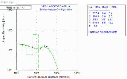
3.1. VES 1
Coordinates: N 09° 02' 21.8", E 007° 30' 51.6", Elevation: 585 m.
The VES 1 curve was interpreted as a three-layer geoelectric sequence (QHK-type), which is highly favorable for groundwater exploration. The derived geo-electric parameters are presented in
Table 1, and the interpreted curve is shown in
Figure 1.
Table 1. Geo-electric parameters for VES 1.
Layer | Resistivity (Ωm) | Thickness (m) | Depth (m) | Interpretation |
1 | 227.4 | 1.4 | 1.4 | Top Layer |
2 | 180.9 | 13.5 | 14.9 | Weathered Layer |
3 | 58.4 | 35.7 | 50.6 | Clay Rich Weathered Zone (Aquitard) |
4 | 610.6 | - | - | Fractured Basement |
The sequence indicates a deep weathering profile with a protective lateritic cap, a clay-rich storage layer, and a well-defined, water-saturated fractured basement aquifer unit, suggesting very good groundwater potential at this location.
Figure 1. Interpreted VES 1 curve and subsurface model.
3.2. VES 2
Coordinates: N 09° 02' 22.7", E 007° 30' 51.0", Elevation: 591 m.
The VES 2 curve was interpreted as a four-layer AA-type curve, characterized by a consistent increase in resistivity with depth (38.8 → 132.0 → 578.0 → 31,982.0 Ωm). This signature is highly anomalous and unfavorable in a basement complex terrain, indicating a progressive lack of weathering and fracturing with depth, culminating in highly impermeable fresh bedrock. The complete absence of a conductive zone suggests a total lack of a water-saturated aquifer unit.
3.3. VES 3
Coordinates: N 09° 02' 22.5", E 007° 30' 50.2", Elevation: 605 m.
The VES 3 curve was interpreted as a three-layer sequence (HKH-type), which is excellent for groundwater exploration. The derived parameters are summarized in
Table 2.
Table 2. Geo-electric parameters for VES 3.
Layer | Resistivity (Ωm) | Thickness (m) | Depth (m) | Interpretation |
1 | 579.6 | 1.2 | 1.2 | Top Layer |
2 | 39.8 | 18.2 | 19.4 | Clay Rich Weathered Layer |
3 | 100.7 | 47.8 | 67.2 | Weathered/Fractured Basement (Aquifer Target) |
4 | 25,917.4 | - | - | Fractured Basement |
This HKH-type curve indicates a protective clay layer overlying a well-developed, water-saturated fracture zone, suggesting excellent groundwater potential.
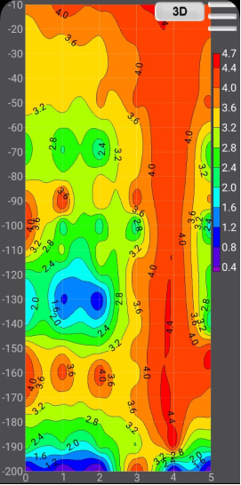
3.4. Electromagnetic (EM) Survey Results
The EM survey provided a continuous 3D profile of the subsurface resistivity variations (
Figure 2). The profile revealed:
Shallow depths (0-50 m): High resistivity values (3.6-4.7 Ωm), corresponding to lateritic overburden and fresh bedrock, suggesting limited groundwater potential.
Intermediate depths (60-120 m): Zones of moderate resistivity (2.0-2.8 Ωm) indicating weathered and fractured basement rocks.
Target depth (120-150 m): A significant low resistivity anomaly (≈1.6-2.0 Ωm) between lateral distances 1.5-2.5, representing a saturated fractured aquifer zone.
Deep depths (160-200 m): Additional low resistivity pockets (0.8-2.0 Ωm) signifying deeper groundwater-bearing formations.
The EM results corroborated the VES findings and were crucial for mapping the lateral continuity of the aquifer identified at VES 1, confirming the most promising groundwater target at depths of 140 to 150 meters.
Figure 2. 3D Electromagnetic isoline graph showing subsurface resistivity distribution.
4. Discussion
The integration of VES and EM methods proved essential for a comprehensive understanding of the heterogeneous basement complex aquifer system. The stark contrast between the results at VES 1/VES 3 (favorable QHK/HKH curves) and VES 2 (unfavorable AA curve) underscores the high variability of aquifer properties over short distances, a well-documented characteristic of basement terrains
| [3] | Ayuba, R., Omonona, O. V., & Onwuka, O. S., 2013. Assessment of groundwater quality of Lokoja basement area, North-Central Nigeria. Journal of the Geological Society of India, 82, 413-420. https://doi.org/10.1007/s12594-013-0168-6 |
| [4] | Doro, K. O., et al., 2025. Understanding complex hydraulic heterogeneities in crystalline basement aquifers. Geosciences, 15(7), 239. https://doi.org/10.3390/geosciences15070239 |
[3, 4]
.
The identified aquifer units within the fourth geoelectric layer at VES 1 and the third layer at VES 3, with resistivities of 610.6 Ωm and 100.7 Ωm respectively, are interpreted as fractured basement zones. Their relatively lower resistivity compared to the massive bedrock (>25,000 Ωm) is attributed to saturation with relatively mineralized water, which increases electrical conductivity
| [5] | Ebele, J. E., et al., 2024. Integrated groundwater exploration in basement complex terrain. Journal of Earth Science & Environmental Studies, 9, 64. https://doi.org/10.2352801X2400064X |
[5]
. The overlying clay-rich layers (e.g., 58.4 Ωm at VES 1) act as crucial aquitards, providing natural storage and protection from surface contamination.
The EM survey successfully addressed the primary limitation of the VES method by providing a continuous lateral profile. The identified low-resistivity anomaly at 120-150 m depth aligns with the predicted aquifer depth from VES 1 and confirms its lateral extent, thereby de-risking the drilling investment. The consistently high resistivity on the right-hand section of the EM profile (x = 4-5) correlates with the poor aquifer conditions inferred from VES 2, validating the integrated approach.
Based on the geophysical evidence, the groundwater prospect is classified as moderately low. This assessment is based on the inferred fracture density and connectivity from the resistivity values, which suggest that while a viable aquifer exists, its yield may not be prolific and will depend significantly on subsequent recharge over time.
5. Conclusions
This integrated geophysical investigation successfully characterized the subsurface conditions at a site in Asokoro, Abuja. The key conclusions are:
1) The subsurface geology comprises 3-4 geoelectric layers, culminating in a fractured basement aquifer system.
2) The groundwater potential within the survey area is highly variable, with VES 1 and VES 3 showing favorable conditions and VES 2 showing unfavorable conditions.
3) The most promising aquifer zone was identified at a depth of approximately 140-150 meters, corresponding to a low-resistivity anomaly on the EM profile.
4) The groundwater yield is anticipated to be moderately low, dependent on the connectivity of the fractured network and recharge.
It is recommended that a production borehole be drilled at the location of VES 1 to a depth of 140- 150 meters using the air hammer (down-the-hole) method suitable for basement rocks. Post- drilling pump tests are essential to accurately determine the sustainable yield of the borehole.
Abbreviations
VES | Vertical Electrical Sounding |
EM | Electromagnetic |
FEM | Frequency-Domain Electromagnetic |
FCT | Federal Capital Territory |
Acknowledgments
The author acknowledges the field team at Bio-metrics Geo consult Limited for their technical assistance during data acquisition.
Author Contributions
Augustine Ubani Daniel: Conceptualization, Data curation, Formal Analysis, Investigation, Methodology, Software, Supervision, Validation, Visualization, Writing – original draft, Writing – review & editing
Funding
This work was not supported by any external funding.
Data Availability Statement
The data is available from the corresponding author upon reasonable request.
Conflicts of Interest
The author declares no conflicts of interest.
References
| [1] |
Adiat, K. A. N., Ajayi, O. F., & Akinlalu, A. A. A., 2020. Prediction of groundwater level in basement complex terrain using artificial neural network: a case of Ijebu-Jesa, southwestern Nigeria. Applied Water Science, 10, 149.
https://doi.org/10.1007/s13201-019-1094-6
|
| [2] |
Anonymous, 2023. Geology and petrography of the basement complex rocks of Tsauni area and environs, Gwagwalada, Abuja FCT. International Journal of Geology and Earth Science, 10(1), 21-37.
https://doi.org/10.18178/ijges.10.1.21-37
|
| [3] |
Ayuba, R., Omonona, O. V., & Onwuka, O. S., 2013. Assessment of groundwater quality of Lokoja basement area, North-Central Nigeria. Journal of the Geological Society of India, 82, 413-420.
https://doi.org/10.1007/s12594-013-0168-6
|
| [4] |
Doro, K. O., et al., 2025. Understanding complex hydraulic heterogeneities in crystalline basement aquifers. Geosciences, 15(7), 239.
https://doi.org/10.3390/geosciences15070239
|
| [5] |
Ebele, J. E., et al., 2024. Integrated groundwater exploration in basement complex terrain. Journal of Earth Science & Environmental Studies, 9, 64.
https://doi.org/10.2352801X2400064X
|
| [6] |
Etuk, M. N., Lartsey, P. E. S., Maduka, R., Ayogu, C. N., & Ogbonnaya, I., 2025. Comparative study of DRASTIC-LU and radioactive isotope approaches for assessing groundwater vulnerability to pollution: the case study of Abuja, North Central Nigeria. Hydrogeology Journal, 33, 1-14.
https://doi.org/10.1007/s43832-025-00191-4
|
| [7] |
Krásný, J., & Sharp, J. M. (Eds.), 2007. Groundwater in Fractured Rocks. IAH Selected Papers.
https://doi.org/10.1007/s10040-024-02792-0
|
| [8] |
MacDonald, A. M., Davies, J., & Calow, R. C., 2008. Developing groundwater: a guide for rural water supply. ITDG Publishing.
https://doi.org/10.3362/9781780441290
|
| [9] |
Offodile, M. E., 2002. Groundwater Study and Development in Nigeria. Mecon Geology and Engineering Services Ltd.
|
| [10] |
Okpoli, C. C., et al., 2020. Groundwater exploration in a typical southwestern Nigeria basement terrain. International Journal of Mining, Reclamation and Environment, 34(7), 511-526.
https://doi.org/10.1080/20909977.2020.1742441
|
| [11] |
Omada, J. I., & Obayomi, O. O., 2013. An assessment of groundwater resources in basement complex terrain of Gwarinpa-Kafe area of Abuja Metropolis, Central Nigeria. Primescholars.
|
| [12] |
Raji, W. O., et al., 2020. Geo-resistivity data set for groundwater aquifer exploration in a basement complex area of Nigeria. Data in Brief, 31, 105975.
https://doi.org/10.1016/j.dib.2020.105975
|
| [13] |
Saidu, A. A., et al., 2024. Groundwater potential mapping in semi-arid region of Nigeria: an AHP & GIS approach. Frontiers in Water, 6, 1484753.
https://doi.org/10.3389/frwa.2024.1484753
|
| [14] |
Sunkari, S. I., Olayinka, A. I., & Sulaimon, A. A., 2023. Hydrogeophysical appraisal of groundwater potential in the fractured basement aquifer of the Federal Capital Territory, Abuja, Nigeria. Journal of African Earth Sciences, 202, 104492.
|
| [15] |
Tijani, M. N., 2023. Geology of Nigeria Precambrian basement complex, sedimentary rocks, Cretaceous & Quaternary alluvial deposit. In: Faniran, A., et al. (Eds.), Landscapes and Landforms of Nigeria, Springer, Cham, pp. 1-35.
https://doi.org/10.1007/978-3-031-17972-3_1
|
Cite This Article
-
APA Style
Daniel, A. U. (2026). Integrated Geophysical Investigation for Groundwater Potential Assessment in a Basement Complex Terrain of Asokoro Abuja Nigeria. Science Research, 14(2), 56-61. https://doi.org/10.11648/j.sr.20261402.14
 Copy
|
Copy
|
 Download
ACS Style
Daniel, A. U. Integrated Geophysical Investigation for Groundwater Potential Assessment in a Basement Complex Terrain of Asokoro Abuja Nigeria. Sci. Res. 2026, 14(2), 56-61. doi: 10.11648/j.sr.20261402.14
Copy
|
Download
AMA Style
Daniel AU. Integrated Geophysical Investigation for Groundwater Potential Assessment in a Basement Complex Terrain of Asokoro Abuja Nigeria. Sci Res. 2026;14(2):56-61. doi: 10.11648/j.sr.20261402.14
Copy
|
Download
-
@article{10.11648/j.sr.20261402.14,
  author = {Augustine Ubani Daniel},
  title = {Integrated Geophysical Investigation for Groundwater Potential Assessment in a Basement Complex Terrain of Asokoro Abuja Nigeria},
  journal = {Science Research},
  volume = {14},
  number = {2},
  pages = {56-61},
  doi = {10.11648/j.sr.20261402.14},
  url = {https://doi.org/10.11648/j.sr.20261402.14},
  eprint = {https://article.sciencepublishinggroup.com/pdf/10.11648.j.sr.20261402.14},
  abstract = {Groundwater is a critical resource in Nigeria, particularly within the crystalline basement complex terrains that underlie much of the country, where its occurrence is constrained to secondary fractures and weathered layers. This study presents an integrated geophysical survey combining Vertical Electrical Sounding (VES) and Frequency-Domain Electromagnetic (FEM) methods to delineate aquifer zones and identify an optimal borehole drilling site at a property in Asokoro, Abuja. The VES data, acquired using a Schlumberger array, revealed varying geoelectric sequences: a promising three-layer QHK-type curve at VES 1 indicating a deep weathering profile and a fractured aquifer, an unfavorable AA-type curve at VES 2 suggesting massive impermeable bedrock, and a highly favorable HKH-type curve at VES 3 signifying a well-developed, water- saturated fracture zone. To overcome site constraints and map lateral continuity, an EM survey was conducted, confirming a low resistivity anomaly indicative of a saturated fractured zone at depths of 120-150 m. Interpretation of the integrated data suggests a moderately low groundwater yield potential, with the aquifer confined within fractured basement rock. It is recommended to drill at the identified point to a depth of 140-150 meters to tap into the identified fractured aquifer unit, which is expected to function as a natural reservoir.},
 year = {2026}
}
Copy
|
Download
-
TY  - JOUR
T1  - Integrated Geophysical Investigation for Groundwater Potential Assessment in a Basement Complex Terrain of Asokoro Abuja Nigeria
AU  - Augustine Ubani Daniel
Y1  - 2026/03/23
PY  - 2026
N1  - https://doi.org/10.11648/j.sr.20261402.14
DO  - 10.11648/j.sr.20261402.14
T2  - Science Research
JF  - Science Research
JO  - Science Research
SP  - 56
EP  - 61
PB  - Science Publishing Group
SN  - 2329-0927
UR  - https://doi.org/10.11648/j.sr.20261402.14
AB  - Groundwater is a critical resource in Nigeria, particularly within the crystalline basement complex terrains that underlie much of the country, where its occurrence is constrained to secondary fractures and weathered layers. This study presents an integrated geophysical survey combining Vertical Electrical Sounding (VES) and Frequency-Domain Electromagnetic (FEM) methods to delineate aquifer zones and identify an optimal borehole drilling site at a property in Asokoro, Abuja. The VES data, acquired using a Schlumberger array, revealed varying geoelectric sequences: a promising three-layer QHK-type curve at VES 1 indicating a deep weathering profile and a fractured aquifer, an unfavorable AA-type curve at VES 2 suggesting massive impermeable bedrock, and a highly favorable HKH-type curve at VES 3 signifying a well-developed, water- saturated fracture zone. To overcome site constraints and map lateral continuity, an EM survey was conducted, confirming a low resistivity anomaly indicative of a saturated fractured zone at depths of 120-150 m. Interpretation of the integrated data suggests a moderately low groundwater yield potential, with the aquifer confined within fractured basement rock. It is recommended to drill at the identified point to a depth of 140-150 meters to tap into the identified fractured aquifer unit, which is expected to function as a natural reservoir.
VL  - 14
IS  - 2
ER  -
Copy
|
Download