Geodetic sciences play a pivotal role in catalyzing socio-economic development and exerting a profound influence on our daily lives. These sciences proffer a multitude of methodologies for obtaining geographic coordinates of land parcels, thereby posing a precision challenge that is integral to effective land management and dispute mitigation. In a broader context, particularly within the unique landscape of Benin, where land is increasingly becoming a valuable commodity, the imperative to optimize land databases is pronounced. Attaining precision in coordinates stands out as a critical factor for effective land management, offering a proactive approach to mitigate potential land disputes. To streamline the process and reduce expenses associated with obtaining land titles for parcels, there is a need to explore strategies that efficiently minimize costs incurred by the array of stakeholders involved in the procedural framework. The focal point of this research is the exploration of the utilization of coordinates derived from openly accessible Geographic Information Systems in the formulation of boundary plans during the verification of land rights. Subsequent to this exploration, the acquired results are systematically compared with coordinates derived through direct field surveys employing the RTK NTRIP methodology. The outcomes infer that, notwithstanding the cadastre.bj website providing coordinates with a precision of four decimal places and being intricately linked to permanent stations, field surveys, despite their elevated cost, persist as the reliable modality for procuring coordinates with centimeter-level accuracy.
| Published in | American Journal of Science, Engineering and Technology (Volume 10, Issue 3) |
| DOI | 10.11648/j.ajset.20251003.15 |
| Page(s) | 130-140 |
| Creative Commons |
This is an Open Access article, distributed under the terms of the Creative Commons Attribution 4.0 International License (http://creativecommons.org/licenses/by/4.0/), which permits unrestricted use, distribution and reproduction in any medium or format, provided the original work is properly cited. |
| Copyright |
Copyright © The Author(s), 2025. Published by Science Publishing Group |
Geodetic Sciences, Geographic Coordinates, Land Parcels and Land Management, Open Access Geographic Information Systems, Land Rights Confirmation, RTK NTRIP Method, Precision Coordinates
Sites | Point No. | Number of Satellites Received by Rover | GNSS Survey in RTK NTRIP Mode (m) | Coordinates Extracted from Google Earth (m) | Discrepancies (m) | |||
|---|---|---|---|---|---|---|---|---|
X | Y | X | Y | d X | d Y | |||
Cotonou | ||||||||
A | A1 | 10/22 | 440704.387 | 704490.632 | 440678.899 | 704474.049 | 3.541 | 3.005 |
A2 | 12/30 | 440704.045 | 704470.656 | 440678.867 | 704443.341 | 4.005 | 1.254 | |
A3 | 11/28 | 440687.253 | 704470.774 | 440678.867 | 704443.341 | 3.997 | 2.215 | |
A4 | 10/28 | 440687.452 | 704490.855 | 440678.899 | 704474.049 | 3.550 | 3.021 | |
B | B1 | 10/26 | 440765.783 | 704430.193 | 440740.246 | 704381.861 | 4.350 | 2.217 |
B2 | 14/31 | 440765.680 | 704410.111 | 440740.246 | 704381.861 | 1.078 | 0.214 | |
B3 | 15/33 | 440743.196 | 704410.405 | 440740.277 | 704412.569 | 2.919 | -0.214 | |
B4 | 13/33 | 440739.561 | 704413.907 | 440740.277 | 704412.569 | -0.716 | 1.338 | |
B5 | 13/32 | 440739.755 | 704426.833 | 440740.277 | 704412.569 | -0.522 | 2.478 | |
B6 | 10/31 | 440743.311 | 704430.383 | 440740.277 | 704412.569 | 3.034 | 3.214 | |
C | C1 | 13/31 | 440723.697 | 704407.719 | 440740.246 | 704381.861 | 0.795 | 4.007 |
C2 | 9/21 | 440709.954 | 704407.852 | 440740.246 | 704381.861 | 3.043 | 1.214 | |
C3 | 13/34 | 440710.395 | 704430.729 | 440740.277 | 704412.569 | 2.145 | 2.214 | |
D | D1 | 12/29 | 440724.597 | 704490.445 | 440709.620 | 704474.017 | 3.215 | 3.875 |
D2 | 10/25 | 440724.112 | 704470.997 | 440709.588 | 704443.309 | 4.024 | 1.047 | |
D3 | 12/30 | 440704.045 | 704470.656 | 440678.867 | 704443.341 | 4.215 | 4.587 | |
D4 | 10/22 | 440704.387 | 704490.632 | 440678.899 | 704474.049 | 3.215 | 0.581 | |
E | E1 | 15/34 | 440510.333 | 704594.192 | 440494.667 | 704566.364 | 3.215 | 2.146 |
E2 | 31/34 | 440510.290 | 704583.892 | 440494.667 | 704566.364 | 1.211 | 1.214 | |
E3 | 16/34 | 440471.232 | 704583.716 | 440463.946 | 704566.396 | 3.215 | 3.214 | |
E4 | 15/33 | 440471.414 | 704594.628 | 440463.946 | 704566.396 | 1.257 | 0.560 | |
Abomey-Calavi | ||||||||
F | F1 | 14/37 | 419372.811 | 713322.855 | 419370.486 | 713313.693 | 2.325 | 6.257 |
F2 | 12/36 | 419347.831 | 713320.071 | 419339.768 | 713313.737 | 8.063 | 2.961 | |
F3 | 14/37 | 419346.188 | 713344.027 | 419339.812 | 713344.446 | 6.376 | -0.419 | |
F4 | 14/38 | 419371.120 | 713346.862 | 419370.530 | 713344.402 | 0.590 | 2.460 | |
G | G1 | 10/25 | 419365.747 | 713419.421 | 419339.900 | 713405.864 | 5.245 | 2.214 |
G2 | 14/36 | 419366.867 | 713395.553 | 419339.856 | 713375.155 | 3.750 | 5.214 | |
G3 | 12/35 | 419343.114 | 713392.002 | 419339.856 | 713375.155 | 3.258 | 4.214 | |
G4 | 10/30 | 419340.944 | 713415.378 | 419339.900 | 713405.864 | 1.044 | 6.257 | |
H | H1 | 10/25 | 418393.520 | 713502.388 | 418387.787 | 713499.362 | 5.733 | 5.782 |
H2 | 8/29 | 418395.920 | 713491.800 | 418387.787 | 713499.362 | 8.133 | -7.562 | |
H3 | 11/31 | 418382.937 | 713500.415 | 418357.070 | 713499.407 | 4.024 | 1.008 | |
J | J1 | 12/30 | 418361.103 | 713431.185 | 418356.936 | 713407.279 | 4.167 | -3.881 |
J2 | 12/30 | 418358.308 | 713424.160 | 418356.981 | 713437.989 | 1.327 | 4.856 | |
J3 | 11/27 | 418350.842 | 713426.449 | 418356.936 | 713407.279 | 4.055 | 2.014 | |
J4 | 11/30 | 418354.175 | 713434.426 | 418326.263 | 713438.033 | 7.254 | -3.607 | |
K | K1 | 9/35 | 419335.394 | 713296.012 | 419309.006 | 713283.072 | 6.245 | 5.254 |
K2 | 11/35 | 419336.509 | 713263.904 | 419308.962 | 713252.362 | 5.254 | 1.201 | |
K3 | 14/35 | 419332.248 | 713263.535 | 419308.962 | 713252.362 | 3.215 | 0.248 | |
K4 | 12/35 | 419330.437 | 713296.148 | 419309.006 | 713283.072 | 7.215 | 3.214 | |
L | L1 | 10/35 | 419334.311 | 713320.606 | 419309.050 | 713313.781 | 5.214 | 2.715 |
L2 | 7/29 | 419334.461 | 713318.491 | 419309.050 | 713313.781 | 6.214 | 4.710 | |
L 3 | 12/32 | 419334.739 | 713311.654 | 419309.050 | 713313.781 | 4.214 | -2.127 | |
L 4 | 10/31 | 419326.612 | 713310.633 | 419309.050 | 713313.781 | 3.214 | -3.148 | |
L5 | 14/36 | 419325.260 | 713317.080 | 419309.050 | 713313.781 | 7.125 | 3.299 | |
L6 | 14/36 | 419324.873 | 713320.358 | 419370.486 | 713313.693 | -1.857 | 2.145 | |
Sites | No. of Points | Satellites Captured by Rover | Coordinates Extracted from Cadastre.bj (m) | GNSS Survey in RTK NTRIP Mode (m) | Discrepancies | |||
|---|---|---|---|---|---|---|---|---|
X | Y | X | Y | dX | dY | |||
Cotonou | ||||||||
A | A1 | 10/22 | 440704.458 | 704492.080 | 440704.387 | 704490.632 | 0.071 | 1.448 |
A2 | 12/30 | 440704.458 | 704471.799 | 440704.045 | 704470.656 | 0.413 | 1.143 | |
A3 | 11/28 | 440687.458 | 704472.097 | 440687.253 | 704470.774 | 0.205 | 1.323 | |
A4 | 10/28 | 440687.756 | 704492.676 | 440687.452 | 704490.855 | 0.304 | 1.821 | |
B | B1 | 10/26 | 440765.530 | 704430.725 | 440765.783 | 704430.193 | -0.253 | 0.532 |
B2 | 14/31 | 440765.232 | 704411.041 | 440765.680 | 704410.111 | -0.448 | 0.93 | |
B3 | 15/33 | 440742.565 | 704411.041 | 440743.196 | 704410.404 | -0.631 | 0.637 | |
B4 | 13/33 | 440739.284 | 704413.725 | 440739.560 | 704413.907 | -0.276 | -0.182 | |
B5 | 13/32 | 440738.986 | 704428.041 | 440739.755 | 704426.833 | -0.769 | 1.208 | |
B6 | 10/31 | 440743.456 | 704431.023 | 440743.311 | 704430.383 | 0.145 | 0.64 | |
C | C1 | 13/31 | 440723.728 | 704409.079 | 440723.697 | 704407.719 | 0.031 | 1.36 |
C2 | 9/21 | 440710.904 | 704408.780 | 440709.954 | 704407.852 | 0.95 | 0.928 | |
C3 | 13/34 | 440710.903 | 704431.447 | 440710.395 | 704430.729 | 0.508 | 0.718 | |
D | D | 12/29 | 440725.157 | 704491.944 | 440724.597 | 704490.445 | 0.56 | 1.499 |
D 2 | 10/25 | 440724.859 | 704471.365 | 440724.112 | 704470.997 | 0.747 | 0.368 | |
D3 | 12/30 | 440704.458 | 704471.798 | 440704.045 | 704470.656 | 0.413 | 1.142 | |
D4 | 10/22 | 440704.458 | 704492.080 | 440704.387 | 704490.632 | 0.071 | 1.448 | |
E | E 1 | 15/34 | 440511.068 | 704595.193 | 440510.333 | 704594.192 | 0.735 | 1.001 |
E2 | 31/34 | 440510.173 | 704584.158 | 440510.290 | 704583.892 | -0.117 | 0.266 | |
E3 | 16/34 | 440471.401 | 704584.792 | 440471.232 | 704583.716 | 0.169 | 1.076 | |
E 4 | 15/33 | 440471.699 | 704595.231 | 440471.414 | 704594.628 | 0.285 | 0.603 | |
Abomey-Calavi | ||||||||
F | F1 | 14/37 | 419369.750 | 713323.317 | 419372.811 | 713322.855 | -3.061 | 0.462 |
F2 | 12/36 | 419345.890 | 713322.124 | 419347.831 | 713320.071 | -1.941 | 2.053 | |
F 3 | 14/37 | 419344.697 | 713345.984 | 419346.188 | 713344.027 | -1.491 | 1.957 | |
F4 | 14/38 | 419368.557 | 713346.879 | 419371.120 | 713346.862 | -2.563 | 0.017 | |
G | G1 | 10/25 | 419365.574 | 713419.055 | 419365.747 | 713419.421 | -0.173 | -0.366 |
G2 | 14/36 | 419366.171 | 713395.493 | 419366.867 | 713395.553 | -0.696 | -0.06 | |
G 3 | 12/35 | 419342.609 | 713393.704 | 419343.114 | 713392.001 | -0.505 | 1.703 | |
G4 | 10/30 | 419341.715 | 713418.160 | 419340.944 | 713415.378 | 0.771 | 2.782 | |
H | H1 | 10/25 | 418395.271 | 713503.675 | 418393.520 | 713502.388 | 1.751 | 1.287 |
H2 | 8/29 | 418398.253 | 713491.447 | 418395.920 | 713491.800 | 2.333 | -0.353 | |
H3 | 11/31 | 418383.937 | 713500.991 | 418382.937 | 713500.415 | 1 | 0.576 | |
J | J 1 | 12/30 | 418363.067 | 713430.597 | 418361.103 | 713431.185 | 1.964 | -0.588 |
J 2 | 12/30 | 418358.593 | 713424.333 | 418358.308 | 713424.160 | 0.285 | 0.173 | |
J 3 | 11/27 | 418351.733 | 713426.421 | 418350.842 | 713426.449 | 0.891 | -0.028 | |
J 4 | 11/30 | 418355.014 | 713434.474 | 418354.175 | 713434.426 | 0.839 | 0.048 | |
K | K 1 | 9/35 | 419335.917 | 713296.624 | 419335.394 | 713296.012 | 0.523 | 0.612 |
K2 | 11/35 | 419337.408 | 713261.133 | 419336.509 | 713263.904 | 0.899 | -2.771 | |
K3 | 14/35 | 419332.636 | 713260.834 | 419332.248 | 713263.535 | 0.388 | -2.701 | |
K4 | 12/35 | 419331.145 | 713296.922 | 419330.437 | 713296.148 | 0.708 | 0.774 | |
L | L1 | 10/35 | 419335.733 | 713321.352 | 419334.311 | 713320.606 | 1.422 | 0.746 |
L 2 | 7/29 | 419335.435 | 713318.966 | 419334.4614 | 713318.491 | 0.9736 | 0.475 | |
L3 | 12/32 | 419336.032 | 713311.509 | 419334.7386 | 713311.6542 | 1.2934 | -0.1452 | |
L4 | 10/31 | 419326.970 | 713310.344 | 419326.612 | 713310.633 | 0.358 | -0.289 | |
L 5 | 14/36 | 419326.075 | 713317.800 | 419325.260 | 713317.079 | 0.815 | 0.721 | |
L6 | 14/36 | 419325.180 | 713321.080 | 419324.873 | 713320.357 | 0.307 | 0.723 | |
L1 | 10/35 | 419335.733 | 713321.352 | 419334.311 | 713320.606 | 1.422 | 0.746 | |
RTK | Real Time Kinematic |
NTRIP | Network and Transport of RTCM via Internet Protocol |
GNSS | Global Navigation Satellite System |
WGS 84 | World Geodetic System 1984 |
ITRF | International Terrestrial Reference System |
UTM | Universal Transverse Mercator |
| [1] |
National Land and Property Agency. NLPA. Confirmation of land rights Available from:
https://www.andf.bj/index.php/procedures-et-demarches/confirmation-des-droits-fonciers (accessed 7 March 2024) |
| [2] | Dhonju, Hari Krishna, Kerry Brian Walsh, and Thakur Bhattarai. "Web Mapping for Farm Management Information Systems: A Review and Australian Orchard Case Study" Agronomy, Geoinformatics Application in Agriculture vol. 13, no. 10. 2563 pp. 1-23. 2023. |
| [3] | Dardanelli, G.; Maltese, A. "On the Accuracy of Cadastral Marks: Statistical Analyses to Assess the Congruence among GNSS-Based Positioning and Official Maps. Remote Sens. "GNSS CORS Application vol 14, no. 16. 4086 pp. 1-21. 2022. |
| [4] | Cahalane, Conor. "Combining 2D Mapping and Low Density Elevation Data in a GIS for GNSS Shadow Prediction" ISPRS International Journal of Geo-Information vol 4, no. 4: pp. 2769-2791. 2015. |
| [5] | Beltrán-Iza, E. A.; Noroña-Meza, C. O.; Robayo-Nieto, A. A.; Padilla, O.; Toulkeridis, T. "Creation of a Mobile Application for Navigation for a Potential Use of People with Visual Impairment Exercising the NTRIP Protocol." Health, Well-Being and Sustainability, vol. 14, no. 24. pp. 1-20. 17027. 2022. |
| [6] | Kyriou, A.; Nikolakopoulos, K.; Koukouvelas, I.; Lampropoulou, P. "Repeated UAV Campaigns, GNSS Measurements, GIS, and Petrographic Analyses for Landslide Mapping and Monitoring." Minerals, Application of UAV and GIS for Geosciences. vol. 11, no. 3. 300. pp 1-26. 2021. |
| [7] | Olcina, J. H.; Julián, A. B. A.; Furones, Á. E. M. "Treatment and Analysis of the GNSS Signal from Smartphones and Its Applicability to Urban Mobility." Environ. Sci. Proc. IV Conference on Geomatics Engineering. vol. 28. no. 1. 1. pp 1-5. 2023. |
| [8] | Janos, D.; Kuras, P. "Evaluation of Low-Cost GNSS Receiver under Demanding Conditions in RTK Network Mode." Sensors - Sensors in Structural Health Monitoring and Smart Structural Control. vol. 21 no. 16. 5552. pp 1-19. 2021. |
APA Style
Kossougbeto, B. K. P. K. P., Yessoufou, M. J., Adeoti, O. G., Ousseni, A., Houehanou, E. C., et al. (2025). Examining the Integration of Geographic Information Systems for Land Rights Confirmation in the Republic of Benin: A Comparative Analysis Using RTK NTRIP Data. American Journal of Science, Engineering and Technology, 10(3), 130-140. https://doi.org/10.11648/j.ajset.20251003.15
ACS Style
Kossougbeto, B. K. P. K. P.; Yessoufou, M. J.; Adeoti, O. G.; Ousseni, A.; Houehanou, E. C., et al. Examining the Integration of Geographic Information Systems for Land Rights Confirmation in the Republic of Benin: A Comparative Analysis Using RTK NTRIP Data. Am. J. Sci. Eng. Technol. 2025, 10(3), 130-140. doi: 10.11648/j.ajset.20251003.15
AMA Style
Kossougbeto BKPKP, Yessoufou MJ, Adeoti OG, Ousseni A, Houehanou EC, et al. Examining the Integration of Geographic Information Systems for Land Rights Confirmation in the Republic of Benin: A Comparative Analysis Using RTK NTRIP Data. Am J Sci Eng Technol. 2025;10(3):130-140. doi: 10.11648/j.ajset.20251003.15
@article{10.11648/j.ajset.20251003.15,
  author = {Briac Kevin Patrick Kevin Patrick Kossougbeto and Moukadamou Joslin Yessoufou and Oyeniran Guy Adeoti and Arouna Ousseni and Ernesto Cabral Houehanou and Gerard Aniwanou and Ange Denagbe},
  title = {Examining the Integration of Geographic Information Systems for Land Rights Confirmation in the Republic of Benin: A Comparative Analysis Using RTK NTRIP Data
},
  journal = {American Journal of Science, Engineering and Technology},
  volume = {10},
  number = {3},
  pages = {130-140},
  doi = {10.11648/j.ajset.20251003.15},
  url = {https://doi.org/10.11648/j.ajset.20251003.15},
  eprint = {https://article.sciencepublishinggroup.com/pdf/10.11648.j.ajset.20251003.15},
  abstract = {Geodetic sciences play a pivotal role in catalyzing socio-economic development and exerting a profound influence on our daily lives. These sciences proffer a multitude of methodologies for obtaining geographic coordinates of land parcels, thereby posing a precision challenge that is integral to effective land management and dispute mitigation. In a broader context, particularly within the unique landscape of Benin, where land is increasingly becoming a valuable commodity, the imperative to optimize land databases is pronounced. Attaining precision in coordinates stands out as a critical factor for effective land management, offering a proactive approach to mitigate potential land disputes. To streamline the process and reduce expenses associated with obtaining land titles for parcels, there is a need to explore strategies that efficiently minimize costs incurred by the array of stakeholders involved in the procedural framework. The focal point of this research is the exploration of the utilization of coordinates derived from openly accessible Geographic Information Systems in the formulation of boundary plans during the verification of land rights. Subsequent to this exploration, the acquired results are systematically compared with coordinates derived through direct field surveys employing the RTK NTRIP methodology. The outcomes infer that, notwithstanding the cadastre.bj website providing coordinates with a precision of four decimal places and being intricately linked to permanent stations, field surveys, despite their elevated cost, persist as the reliable modality for procuring coordinates with centimeter-level accuracy.
},
 year = {2025}
}
TY  - JOUR
T1  - Examining the Integration of Geographic Information Systems for Land Rights Confirmation in the Republic of Benin: A Comparative Analysis Using RTK NTRIP Data

AU  - Briac Kevin Patrick Kevin Patrick Kossougbeto
AU  - Moukadamou Joslin Yessoufou
AU  - Oyeniran Guy Adeoti
AU  - Arouna Ousseni
AU  - Ernesto Cabral Houehanou
AU  - Gerard Aniwanou
AU  - Ange Denagbe
Y1  - 2025/09/19
PY  - 2025
N1  - https://doi.org/10.11648/j.ajset.20251003.15
DO  - 10.11648/j.ajset.20251003.15
T2  - American Journal of Science, Engineering and Technology
JF  - American Journal of Science, Engineering and Technology
JO  - American Journal of Science, Engineering and Technology
SP  - 130
EP  - 140
PB  - Science Publishing Group
SN  - 2578-8353
UR  - https://doi.org/10.11648/j.ajset.20251003.15
AB  - Geodetic sciences play a pivotal role in catalyzing socio-economic development and exerting a profound influence on our daily lives. These sciences proffer a multitude of methodologies for obtaining geographic coordinates of land parcels, thereby posing a precision challenge that is integral to effective land management and dispute mitigation. In a broader context, particularly within the unique landscape of Benin, where land is increasingly becoming a valuable commodity, the imperative to optimize land databases is pronounced. Attaining precision in coordinates stands out as a critical factor for effective land management, offering a proactive approach to mitigate potential land disputes. To streamline the process and reduce expenses associated with obtaining land titles for parcels, there is a need to explore strategies that efficiently minimize costs incurred by the array of stakeholders involved in the procedural framework. The focal point of this research is the exploration of the utilization of coordinates derived from openly accessible Geographic Information Systems in the formulation of boundary plans during the verification of land rights. Subsequent to this exploration, the acquired results are systematically compared with coordinates derived through direct field surveys employing the RTK NTRIP methodology. The outcomes infer that, notwithstanding the cadastre.bj website providing coordinates with a precision of four decimal places and being intricately linked to permanent stations, field surveys, despite their elevated cost, persist as the reliable modality for procuring coordinates with centimeter-level accuracy.

VL  - 10
IS  - 3
ER  -
Laboratory of Geosciences, Environment, and Applications, National University of Science, Technology, Engineering and Mathematics, Abomey, Republic of Benin
Laboratory of Processes and Technological Innovations, National University of Science, Technology, Engineering and Mathematics, Abomey, Republic of Benin
Laboratory of Testing and Studies in Civil Engineering, National University of Science, Technology, Engineering and Mathematics, Abomey, Republic of Benin
Laboratory of Geosciences, Environment, and Applications, National University of Science, Technology, Engineering and Mathematics, Abomey, Republic of Benin
Laboratory of Processes and Technological Innovations, National University of Science, Technology, Engineering and Mathematics, Abomey, Republic of Benin
Higher School of Geomatics Engineers, Cotonou, Republic of Benin
National Geographic Institute, Cotonou, Republic of Benin
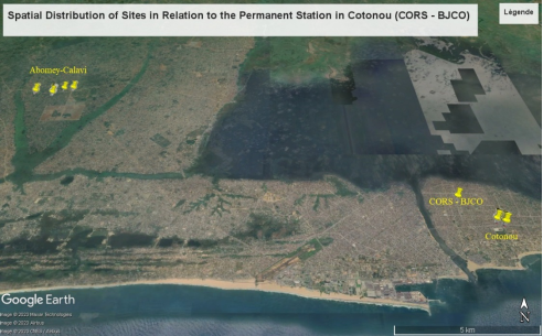
Figure 1. Spatial Distribution of Sites in Relation to the Permanent Station in Cotonou.
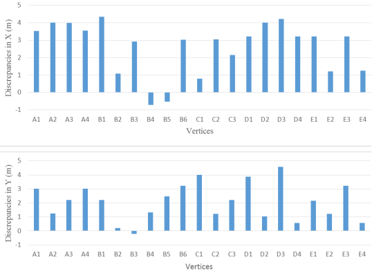
Figure 2. Relative discrepancies in coordinates obtained through direct survey in RTK NTRIP mode compared to those derived from Google Earth along the X and Y axes in the Cotonou region.
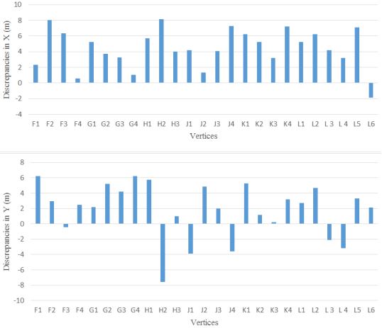
Figure 3. Relative discrepancies in coordinates acquired through direct survey in RTK NTRIP mode and those derived from Google Earth along the X and Y axes in Abomey-Calavi.
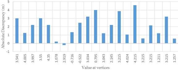
Figure 4. Absolute Discrepancy in Coordinates Acquired via GNSS Receiver in RTK NTRIP Mode and Extracted from the Google Earth Application in Cotonou.
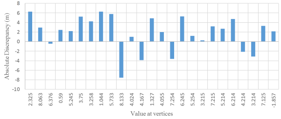
Figure 5. Absolute Discrepancy in Coordinates Acquired via GNSS Receiver in RTK NTRIP Mode and Extracted from the Google Earth Application in Abomey-Calavi.
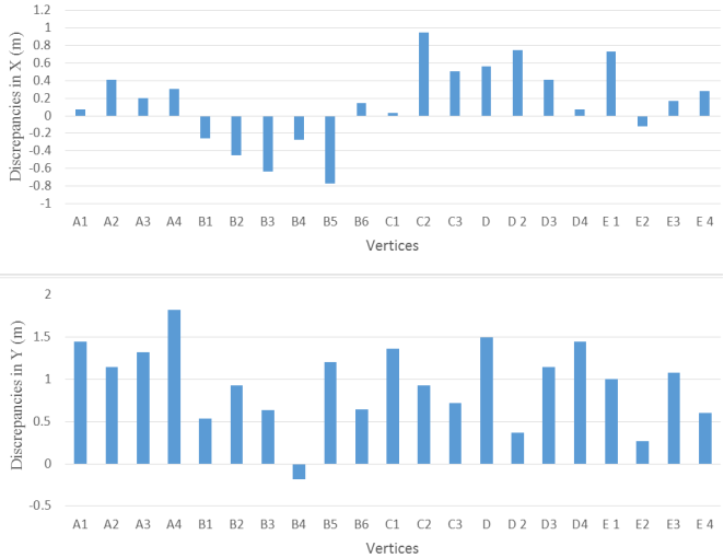
Figure 6. Relative discrepancies along the X and Y axes between coordinates acquired through direct survey using RTK NTRIP mode and those derived from the cadastre.bj website in the Cotonou region.
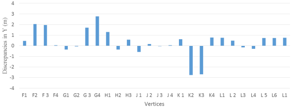
Figure 7. Relative discrepancies between coordinates obtained by direct survey in RTK NTRIP mode and those derived from the cadastre.bj website along the X and Y axes in Abomey-Calavi.
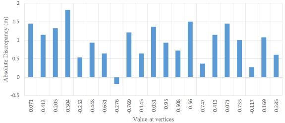
Figure 8. Absolute Discrepancy between Coordinates Obtained by GNSS Receiver in RTK NTRIP Mode and Extracted from the cadastre.bj Website in Cotonou.
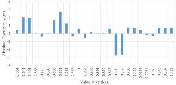
Figure 9. Absolute Discrepancy between Coordinates Obtained by GNSS Receiver in RTK NTRIP Mode and Extracted from the cadastre.bj Website in Abomey-Calavi.
Information

