2. Materials and Methods
2.1. Study Site
Figure 1. Aerial view of the Dschang-Foréké cliff.
The Foreke-Dschang escarpment is located 10 km in southwest Dschang toen. It shows a vertical difference of 700 m between Dschang (1400 m) and Santchou (700 m). An aerial view of the cliff shows anthropogenic activies such as agriculture on the slopes and gallery forests along the watercourses (
Figure 1). The climate temperate and depends on a unit of factors that are linked not only to the relief and the exposure of this region to major atmospheric currents. It also depends on its geographical position and distance from the sea
[2] | Aboubakar B., Kagou Dongmo A., Nkouathio DG & Ngapgue F. (2013). Ground instabilities in the highlands of western Cameroon: geological and geotechnical characterization of the Kekem landslide. Bulletin of the Scientific Institute, Rabat, Earth Sciences Section, No. 35, 39–51. |
[2]
. The annual precipitation is abundant (1400- 2500 mm) with peaks between July and October, decreasing from South to North while increasing in the vicinity of the mountain ranges. The drainage network is linked to the relief of the landscape
[2] | Aboubakar B., Kagou Dongmo A., Nkouathio DG & Ngapgue F. (2013). Ground instabilities in the highlands of western Cameroon: geological and geotechnical characterization of the Kekem landslide. Bulletin of the Scientific Institute, Rabat, Earth Sciences Section, No. 35, 39–51. |
[2]
. The forest and wooded savannah vegetation is heavily anthropized by a predominantly agricultural population
[9] | Moundjeu ED (2022) - Characterization of steep slope soils and stability of slopes of the Foréké-Dschang Cliff, West Cameroon. PhD thesis, Univ. Dschang, 115 p. |
[9]
. Geologically, the region is dominated by the Pan-African granito-gneissic basement which is intruded by Tertiary to recent volcanics (rhyolitic, trachytic and basaltic flows, and basaltic and ignimbritic projections)
[2] | Aboubakar B., Kagou Dongmo A., Nkouathio DG & Ngapgue F. (2013). Ground instabilities in the highlands of western Cameroon: geological and geotechnical characterization of the Kekem landslide. Bulletin of the Scientific Institute, Rabat, Earth Sciences Section, No. 35, 39–51. |
[2]
. The geomorphology of the region, the geological nature and age of the formations, as well as tectonic action combine with climatic conditions and sometimes anthropogenic actions to make the highlands of Western Cameroon a region at high risk of mass movement
[1] | Aboubakar, B. 2010. Geological and geotechnical study of mass movements in the highlands of West Cameron: case of the sites of Lepoh and Nteingue (Menoua department) and Tchouaffé (Haut-Nkam department). Master's theses, Univ. Dschang. 130 p. |
[1]
. Throughout this region, scars of old land movements and signs of aborted or ongoing movements are observed
[2] | Aboubakar B., Kagou Dongmo A., Nkouathio DG & Ngapgue F. (2013). Ground instabilities in the highlands of western Cameroon: geological and geotechnical characterization of the Kekem landslide. Bulletin of the Scientific Institute, Rabat, Earth Sciences Section, No. 35, 39–51. |
[2]
. The soils are classified into four categories
[9] | Moundjeu ED (2022) - Characterization of steep slope soils and stability of slopes of the Foréké-Dschang Cliff, West Cameroon. PhD thesis, Univ. Dschang, 115 p. |
[9]
: poorly differentiated soils or lithosols developed on the crystalline basement are observed at the top of the interfluves and on very steep slopes; very desaturated ferrallitic soils on basement, developed on slopes less than 13% and at the foot of steep slopes; Moderately desaturated ferrallitic soils on volcanic rocks observed on the slopes of the interfluves; and more or less saturated lowland hydromorphic soils, more or less humiferous, located at the bottom of slopes and strongly influenced by the watertable. Intensive agriculture is the main practice with rare fallow lands. Most farmers practice mixed cropping where crops like Arabica coffee, plantains, banana, beans, maize, cassava, etc. are being grown on the same piece of land.
2.2. Methodology
2.2.1. Fieldwork
The description of the biophysical environment of the site consisted of observing and describing the landscape, in particular the plant cover, the relief forms, the anthropogenic activities, the description of soil and especially the mode of movement operated during this double landslide.
Disturbed soil samples (at four levels: bottom of slope (BP), middle of slope (MP), top of slope (SP) and control (forest)) were collected. Samples were carefully taken using cylindrical plastic corers (height = 25 cm, diameter = 16 cm), embedded in paraffin, labeled and sent to the laboratory for further processing and analysis. Rocks samples were also collected for petrographic analysis. The samples were then taken to the laboratory for analysis.
2.2.2. Laboratory Analysis
In the laboratory, petrographic and geotechnical parameters of the rocks and soils were performed.
The petrographic analysis involved the cutting of thin sections of the rock and microscopic observations with a using a polarizing microscope. This was done at the Environmental Geology Laboratory of the University of Dschang (Cameroon).
The geotechnical analyses of soils focused on particle size distribution analysis, hydraulic conductivity (Ks), liquidity and plasticity limits, cohesion coefficient (C) and the angle of internal friction φcu (°). The geotechnical analyses were done at the Research Unit for Soil Analysis and Environmental Chemistry (RUSAEC) of the Faculty of Agronomy and Agricultural Sciences of the University of Dschang using the methods in force, recommended by
[10] | Pauwels, J. M., Ranst. E. V., Verloo M. et Mvondo-Ze A.(1992) - Manuel de laboratoire de pédologie: Méthodes d’analyses des sols et de plantes, équipements, gestion des stocks de verrerie et de produits chimiques. Vol. 28. Bruxelles: Publications Agricoles. |
[10]
and complying with International Organization for Standardization (IOS) and French Standardization Association (FSA).
Finally, slope map, occupation map and landslide risk level map were developed from the data acquired.
3. Results and Discussion
3.1. Petrography of the Parent Materials
In the study area, Biotite and amphibole gneiss and Biotite and amphibole granite are the the principal parent materials of the soils.
3.1.1. Biotite and Amphibole Gneiss
It outcrops in slabs (
Figure 2a) and balls below the hills in the locality of Foreké-Dschang. In places, it is observed in contact with the biotite and amphibole granite. Its grain is fine and its color is dark gray. The rock has a foliated structure, characterized by the alternation of light-colored beds of millimeter thickness and dark levels of millimeter thickness. The light-colored beds are rich in quartz and feldspars. The dark levels are rich in biotite and amphibole.
Under the microscope, this rock has a heterogranular granoblastic microstructure (
Figure 2b). The main minerals are: alkali feldspar, quartz and plagioclase.
Plagioclase (35%) occurs in sub-automorphic sections up to 1.5mm in size. It contains inclusions of apatite, biotite, green hornblende and sphene. Quartz (25%) occurs in xenomorphic sections ranging in size from 0.3 mm to 0.5 mm. They are associated with plagioclase and orthoclase in the light bands. Alkali feldspar (20%) occurs in sub-automorphic sections and is represented by orthoclase ranging in size from 0.5 to 0.9 mm. It contains biotite, green hornblende, allanite, apatite and sphene as inclusions.
Figure 2. Outcrop mode (a) and microphotographs (b, c and d) of biotite and amphibole gneiss in the Foreke-Dschang locality.
3.1.2. Biotite and Amphibole Granite
Figure 3. Outcrop mode (a) and microphotographs (b, c and d) of biotite and amphibole granite in the Foreke-Dschang locality.
The biotite and amphibole granite outcrops in the form of balls, blocks or slabs (
Figure 3a). In places, the latter is in a vein in the biotite-amphibole gneiss. At the outcrop, the biotite-amphibole granite is dark gray in color, medium-grained with millimeter-sized minerals.
Under the microscope, the rock shows a porphyroidal grainy texture (
Figure 3b).
It is composed of quartz, alkali feldspar, plagioclase, biotite, and amphibole. Apatite, zircon, sphene, and opaque minerals are also found. Quartz (35%) is colorless with sinuous contours and generally in xenomorphic crystals, less than 0.8 mm in size. It occurs in sub-grains or in flattened sections with rolling extinction, thus forming polycrystalline ribbons (
Figure 3c). Quartz contains plagioclase and biotite as inclusions. Plagioclase (25%) occurs in the form of large sub-automorphic patches. Its size is between 0.5 and 1.2 mm. The plagioclase sections are colorless and are identified by the presence of the polysynthetic twin of albite. Locally, this twin is flexuous. The plagioclase crystals are in places affected by micro-fractures filled with quartz (
Figure 3b) or biotite flakes. Alkali feldspar (20%) is automorphic to sub-automorphic, up to 1mm in size. It has fractures perpendicular to the long axis of the mineral. It contains biotite, plagioclase, and opaque minerals as inclusions. (
Figure 3b).
3.2. Nature of the Weathering Mantle and the Physical Environment
3.2.1. Soils of the Foreke-Dchang Escarpment
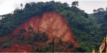
Figure 4. Morpho-structural view of the soils of the Foreke-Dschang cliff.
In situ descriptions indicate the humid tropical climate has led to intense weathering of the granito-gneissic basement forming a mantle of saprolite-type alterites up to 8 m thick. This weathering mantle constitutes a friable, fragile complex that is very sensitive to water input. The weathering set are topped by medium-thick size soils with a sandy-clay texture on which the presence of sandy colluvium and coarse scree is often possible. In conditions of steep slope, the rupture of the terrain can occur at the scale of a slope. The very thick profiles in the locality illustrate the extent of this phenomenon. Indeed, the soil profiles are 2 to 18 m thick in places from the A horizon to the BC horizons (
Figure 4). Also, the weathering mantle rests on granular rocks such as gneisses and granites which release abundant in the BC horizons.
The soil profile described (
Figure 5) is located at an altitude of 1320 m at N05°14'06.3'' and E010
o 00'24.5''. It is under a shrubby vegetation cover. It is in the vicinity of the plantain-banana cultivation area, on the slope of the flank that created an amphitheater during the last double translational landslide. From top to bottom, the profile of about 18 m in thickness is divided into three horizons (A, B and BC).
From 0-10 cm, there is an A horizon, dark gray in color (5YR5/2) when dry, with a clayey loam texture, granular structure, coarse fragments such as root activity of variable size testifying to its significant porosity as well as traces of biological activity marked by the presence of ants. The boundary between this horizon and the lower horizon is clear and wavy.
From 15-70cm, there is a mineral horizon B, red-brown in color (2.5YR3/6), with a granular structure, clayey texture and high compactness. The presence of rootlets and medium porosity are noted. It presents a diffuse and gradual boundary with the BC horizon below.
From 70cm to more than 18 m depth, there is a BC horizon, with a polyhedral structure, friable when dry, whitish red in color (2.5YR6/8), with a sandy clayey texture. The parent material is highly weathered with the partial conservation of the original structure of the parent material (alloterite) and is associated with the mineral matter. The ABC type profile is a ferrallitic soil resulting from the weathering of granitic rocks.
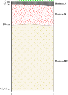
Figure 5. Morphological organization of the soil profile at the Foreke-Dschang escarpment.
3.2.2. Relief or Topography
The Foreke-Dschang escarpment model shows a rugged relief characterized by steep slopes with a high inclination (
Figure 6). Indeed, the analysis of the slope map made it possible to distinguish three slope classes: < 6%, 6 -10% and the >10% in reference to
[15] | United States \geological Survey, USGS (2004). Landslide type and processes. Fact sheet 2004-3072, New York. |
[15]
. To these three slope classes, three levels of landslide risks are respectively associated: very low to low risk level (i.e. 45.31% of the total surface area), moderate risk level (i.e. 41.53% of the total surface area) and the high to very high risk level (i.e. 13.14% of the total surface area).
Indeed, the hill that suffered the double landslide on November 5, 2024, belongs to the slope class between 10 and 20% and presents a high to very high landslide risk level. Therefore, this hill represents a high to very high landslide risk as a whole. Furthermore, a careful observation shows that the National Road No. 4 is located on a slope class greater than 10% and presents a high to very high landslide risk level.
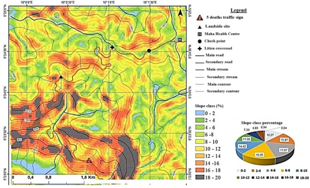
Figure 6. Slope map of the Foreke-Dschang escarpment.
All the slopes have a very high susceptibility to landslides (with the exception of lowlands) which varies depending on the slope. Thus, lowlands and northern slopes of hills are less susceptible, while the North-East (NE), South-East (SE), South (S), South-West (SW), West (W) and North-West (NW) slopes are the most susceptible to landslides. A detailed analysis of the slope exposure map shows that the entire National Road No. 4 is located on slopes with a very high susceptibility to landslides (
Figure 7).
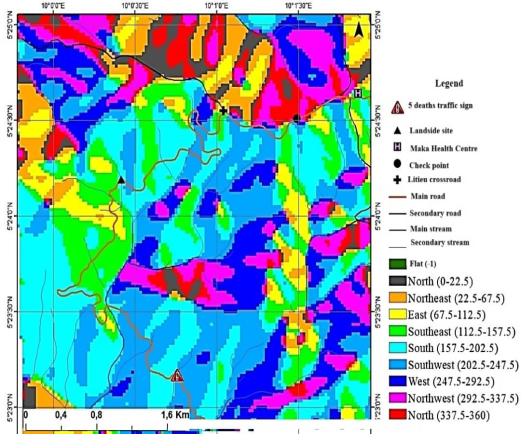
Figure 7. Slope exposure map.
Based on the landslide risk levels, two safety perimeters can be identified along the National Road No. 4, namely the 50 m safety perimeter and the 100 m safety perimeter. The implementation of one or the other safety perimeter will depend on the available financial resources (
Figure 8).
Figure 8. Landslide risk level map of the cliff.
3.2.3. Precipitation
The rains from June to November 2024 in Dschang were exceptionally abundant. Indeed, an average of 1763mm of rain was recorded this year, of which only 402mm or 23% of the rainwater, is likely to infiltrate. The wettest period is between June (224mm/year) and September (326mm/year)
[9] | Moundjeu ED (2022) - Characterization of steep slope soils and stability of slopes of the Foréké-Dschang Cliff, West Cameroon. PhD thesis, Univ. Dschang, 115 p. |
[9]
. These heavy rains would have saturated the upper set of the alterites with a silty-clayey texture and increased their mass. This set, under the double effect of its mass and the steep slope, would have thus slid and planed parallel and obliquely without collapse of the materials, on the lower set, predominantly sandy-clayey, very permeable and unstable. At the end of this mass displacement without collapse of the materials, a mass movement called “LANDSLIDE" had just occurred on a steep hill in the locality of La Falaise, in the town of Dschang, in the West-Cameroon region, blocking access to the road. In short, the appearance of this landslide is linked to the recent heavy rainfall, to which is added the absence of water drainage structures along national road No. 4.
3.2.4. Land Use and Occupation
The main land use themes at the Foreke-Dschang escarpment (
Figure 9) are forest (48.62%), savannah and cropland (35.68%), bare soil and built-up areas (15.70%). Indeed, the Foreke-Dschang escarpment is very heavily anthropized and this anthropization results in the reconversion of forests, either into savannahs and crop areas or into urbanized areas and bare soil. Observation of the land use map shows that the location of the double landslide as well as along the regional road are occupied by crops and/or built-up areas.
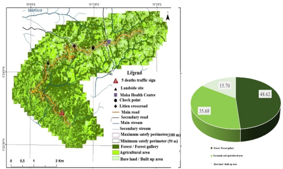
Figure 9. Land use map (above) and distribution of themes (below).
3.3. Geotechnical Characterization of Materials
The results of particle size distribution analysis are presented in
Table 1. There is a predominance of the fine fraction in SP (59.7%) and a predominance of the coarse fraction in HP (68%) and BP (67%). Soil texture is silty-clayey at the top of the slope and silty-sandy in the middle and bottom of the slope. The physical and mechanical parameters of the soils are recorded in
Tables 2 and 3 respectively.
Table 2 shows that the water contents vary from 20.1±1.1 to 25.1±1.4% and are below the liquid limit (40.1-55.8%). The void ratio varies between 0.84±0.05 and 0.89±0.01. As for the porosity (n), it varies between 45±1.0 and 49±2.0%. The liquid and plastic limits are close for the MP and BP samples (41.9±1.2 and 40.1±2.2%) and (26.0±3.4 and 25.6±2.4%). It is evident from
Table 3 that the materials in the study area have a cohesion coefficient of 0.09±0.02 bar, 0.29±0.03 bar and 0.17±0.01 bar respectively for SP, MP and BP and the BP, MP and SP materials have respectively the internal friction angles 18.26±3.45, 19.07±2.75 and 24.89±4.80 high. The hydraulic conductivity (Ks) increases from the top (2.65.10
-7m/s) to the base (3.54.10
-4 m/s).
Table 4 shows that the organic matter content is high in the forest (8.84±1.70%) and lower in the SP (1.20±0.90%).
Table 1. Percentages of particle size fractions of SP, MP and BP samples.
Samples | Gravel% | Sand% | Silt% | Clay% |
SP | 0.03±0.00 | 40.00±12.00 | 24.97±10.25 | 35.00±14.00 |
MP | 0.04±0.00 | 68.00±22.00 | 24.96±11.43 | 17.00±8.00 |
BP | 0.05±0.00 | 67.00±17.00 | 21.95±9.23 | 11.00±5.00 |
Table 2. Physical parameters of materials.
Ech | n (%) | W (%) | Sr (%) | Wl (%) | W p (%) | Ip (%) | Here | I W | Da (g/cm3) | Dr (g/cm 3) | e | C |
SP | 49±2.0 | 25.1±1.4 | 81±3.0 | 55.8±2.3 | 29.8±1.8 | 26.0±2.7 | 1.20±0.45 | 0.96±0.14 | 1.35±0.03 | 2.65±0.02 | 0.84±0.05 | 0.54±0.11 |
MP | 48±3.0 | 20.1±1.1 | 73±4.0 | 41.9±1.2 | 26.0±3.4 | 15.9±2.5 | 1.40±0.08 | 1.26±0.07 | 1.42±0.14 | 2.75±0.02 | 0.79±0.01 | 0.56±0.13 |
BP | 45±1.0 | 20.4±1.2 | 63±4.2 | 40.1±2.2 | 25.6±2.4 | 14.50±1.2 | 1.40±0.06 | 1.40±0.06 | 1.44±0.02 | 2.64±0.04 | 0.89±0.01 | 0.53±0.11 |
n: porosity, W: water content, Sr: water saturation rate, W l: liquid limit, Wp: plasticity limit, Ip: plasticity index; Ic: consistency index, Iw: workability index, Da: apparent density, Dr: true density, e: void ratio, C: compactness
Table 3. Mechanical soil parameters by slope position.
Samples | Cohesion C (bar) | Internal friction angle φcu (°) | Ks (m/s) |
SP | 0.09±0.02 | 24.89±4.80 | 2.65.10-7 |
MP | 0.29±0.03 | 19.07±2.75 | 2.43. 10-4 |
BP | 0.17±0.01 | 18.26±3.45 | 3.54.10-4 |
Table 4. Chemical characteristics of the cliff soils under cultivation and control (Forest).
Code | BP | MP | SP | Forest |
CO% | 1.05 ±0.94 | 0.78±0.67 | 0.69±0.52 | 4.42 ±0.71 |
N (g/kg) | 1.03 ±0.90 | 0.89±0.07 | 0.9±0.04 | 0.54 ±0.11 |
C/N | 10.19 | 8.66 | 8.72 | 81.85 |
The C/N ratio is high in the forest (81.85) compared to 10.19 in BP, 8.66 in MP and 8.72 in SP. This high ratio in the forest is explained by poor mineralization justified by the presence of fresh organic matter in large quantities which plays the role of protecting the soil against erosion. This low rate of organic matter is due to agricultural practices on these steep slopes, the consequence of which would be runoff towards watercourses and then cause violent and devastating floods during heavy rains. To this end, the severe erosion which would result would produce unstable slopes which could in places suffer landslides.
4. Discussion
Field observations and analyses carried out during this work show that several factors contributed to the double landslide in the locality of Foreke-Dschang. These can be grouped into natural factors and anthropogenic factors. The study of the rocks in the area shows that they are characterized by fracturing and grinding of the original rock elements.
Naturally, the gness and granite, dominant rocks in the area, are mostly composed of plagioclase, biotite and Amphibole. The weathering index of these minerals is greater than or equal to 4
[8] | Godard A. (1962)- Essai de corrélation entre l’altitude des reliefs et les caractères pétrographiques des roches dans le socle de l’Ecosse du Nord. C. R. Acad. Sc. Paris, 235, 139–141. |
[8]
. Overall, the presence of a high proportion of fine materials (silts and clays) is always an unfavorable element given their poor mechanical characteristics. Furthermore, the intense rainfall in the study area increases the hydraulic pressure loaded with ions at significant depths in the rock mass. It breaks the bridges of the intact rock which plays a very important role in the stability of the rock mass
[6] | Curtaz, M., A. Sergalini., AM Ferrero, G. Umili., and Roncella R. (2014). Terrestrial photogrammetry and numerical modeling for the stability analysis of rock slopes in high mountain areas: Aiguilles Marhrées case. Rock Mechanics and rocks Engineering 47(2), 605-620. https://doi.org/10.1007/s00603-013-0446-z |
[6]
. In addition, granite is a rock rich in quartz and feldspars. The feldspars weather to give clays. It is these clays which are partly at the origin of landslides during heavy rains because of their high water saturation rate (>60%), with poor internal drainage (low Ks) which must reduce the cohesion between the particles and increase the internal friction angle (18-24°). Hence the instability of the soils at the top of the slope (SP) which have a clayey texture according to
[5] | Casagrande, A. 1948. Classification and identification of soils. ASCE Transactions, Vol. 113, pp 901-930. |
[5]
. This instability is justified by the low values of the workability index (I
w). These results are in agreement with those found by
[2] | Aboubakar B., Kagou Dongmo A., Nkouathio DG & Ngapgue F. (2013). Ground instabilities in the highlands of western Cameroon: geological and geotechnical characterization of the Kekem landslide. Bulletin of the Scientific Institute, Rabat, Earth Sciences Section, No. 35, 39–51. |
[2]
who showed a drop in the resistance of some soils in the Cameroon Western highlands saturated with water. The slope is very steep (>30°) in the site, enough to create the gravity contrast and induce the mass movement because It is also one of the determining factors in the genesis of landslides. This result is confirmed by
who show that the origin of mass movements in Maga (North-West Cameroon) is linked to the rugged relief with steep slopes. The vegetation cover also contributed to the triggering because
[4] | Asada H. and Minagawa T. (2023) -Impact of Vegetation Differences on Shallow Landslides: A Case Study in Aso, Japan. Water, 15, 1-23. https://doi.org/10.3390/w15183193 |
[5] | Casagrande, A. 1948. Classification and identification of soils. ASCE Transactions, Vol. 113, pp 901-930. |
[6] | Curtaz, M., A. Sergalini., AM Ferrero, G. Umili., and Roncella R. (2014). Terrestrial photogrammetry and numerical modeling for the stability analysis of rock slopes in high mountain areas: Aiguilles Marhrées case. Rock Mechanics and rocks Engineering 47(2), 605-620. https://doi.org/10.1007/s00603-013-0446-z |
[7] | Ediamam Epalle GM (2023) - Landsides on the escarpments of Western highlands and flash floods in the Mbos plain (West-Cameroon). Canadian Journal of Tropical Geography CJTG (Online), 8(2), 58-65. |
[8] | Godard A. (1962)- Essai de corrélation entre l’altitude des reliefs et les caractères pétrographiques des roches dans le socle de l’Ecosse du Nord. C. R. Acad. Sc. Paris, 235, 139–141. |
[9] | Moundjeu ED (2022) - Characterization of steep slope soils and stability of slopes of the Foréké-Dschang Cliff, West Cameroon. PhD thesis, Univ. Dschang, 115 p. |
[10] | Pauwels, J. M., Ranst. E. V., Verloo M. et Mvondo-Ze A.(1992) - Manuel de laboratoire de pédologie: Méthodes d’analyses des sols et de plantes, équipements, gestion des stocks de verrerie et de produits chimiques. Vol. 28. Bruxelles: Publications Agricoles. |
[11] | Tangmouo Tsoata F., Yemmafouo A. and Ngouanet C. (2021) - Landslide susceptibility mapping in Bafoussam (Cameroon). Hierarchical multi-criteria analysis approach and Geographic Information System. International Journal of Geomatics, Planning and Resource Management, 7-8. Tchoua, FM, 1984. The mudflows of Dschang (August 1978). Rev. Géogr. Cam. IV n 2, pp. 25-33. |
[12] | Tchoua, F. M.(1984).-Les coulées boueuses de Dschang (Aout 1978). Rev. Géogr. Cam. IV n 2, pp 25 33. |
[13] | Tchoua, FM, (1989)- The mudflows of Dschang (August 1978). Rev. Géogr. Cam. 8, 58-64. |
[14] | Wen H., Li W., Xu C. and Daimaru H. (2023) - Landslides in Forests around the World: Causes and Mitigation. Forests, 1-4. https://doi.org/10.3390/f14030629 |
[4-14]
showed that vegetation consisting of trees and even shrubs would constitute an additional mass on the large mass of the weathering mantle and would therefore promote landslides in conditions of heavy rainfall in mountainous areas. These results are in contraction with those found by
[12] | Tchoua, F. M.(1984).-Les coulées boueuses de Dschang (Aout 1978). Rev. Géogr. Cam. IV n 2, pp 25 33. |
[13] | Tchoua, FM, (1989)- The mudflows of Dschang (August 1978). Rev. Géogr. Cam. 8, 58-64. |
[12, 13]
who reported that abundant vegetation would be important in protecting the soil during mudslides.
Human activities on the soils of the locality of Foreke Dschang have contributed to weakening their stability through the reconversion of the natural landscape into cultivated areas. In this case, the cultivation of forests and savannah would have created a dysfunction of the water regime and the role played by trees through their root system in soil stability. This cultivation will contribute through regular plowing to loosen the surface levels and to increase the infiltration rate. Organic matter helps soils resist disintegration, settlement (structural stability) and compaction through its ability to form stable organo-mineral complexes that give the soil plastic properties
[9] | Moundjeu ED (2022) - Characterization of steep slope soils and stability of slopes of the Foréké-Dschang Cliff, West Cameroon. PhD thesis, Univ. Dschang, 115 p. |
[9]
. The organic matter content decreases along the toposequence compared to the control (Forest) due to agricultural practices on this slope. This low organic matter rate weakens the slopes due to the loss of soil through erosion during heavy rains because according to
[3] | Ancelin, O., & Duranel, J. (2007). Soil and Organic Matter Memento-Agro-Transfer R&T and Picardy Chambers of Agriculture. |
[3]
, fresh organic matter, when left on the surface, provides physical protection for the soil against the action of rain (impact of drops which create a "splash" effect, where there is bursting of aggregates and detachment of fine earth particles from the surface of these aggregates). These results are similar to those found by
[9] | Moundjeu ED (2022) - Characterization of steep slope soils and stability of slopes of the Foréké-Dschang Cliff, West Cameroon. PhD thesis, Univ. Dschang, 115 p. |
[9]
in the same locality of Foreke-Dschang. The exploitation of gneiss for the foundations of houses and the sand obtained by washing the earth dug at the foot of the mountains could also be the cause of the fragility of the soils of the steep slopes observed. This observation had already been documented by
[1] | Aboubakar, B. 2010. Geological and geotechnical study of mass movements in the highlands of West Cameron: case of the sites of Lepoh and Nteingue (Menoua department) and Tchouaffé (Haut-Nkam department). Master's theses, Univ. Dschang. 130 p. |
[1]
on the sites of Lepoh, Nteingue and Tchouaffé. The road layout of the Foreke-Dschang escarpment would have facilitated the double landslide. In fact, the excavations of the ground following a section perpendicular to the slope for the installation of the road would have broken the continuity of the slope and would have made the upper section of the road unstable, which would have finally given way to the combination of other triggering factors. The intensity of traffic and the passage of machinery, which are the sources of vibrations and local shocks are contributing factors of slope destabilization.
Based on the results, the following recommendations are suggested to control landslides within the defined perimeters along National Road No. 4:
1) Terraces or low walls should be built to prevent the earth from the upper ground from sliding onto the lower part, and thus lighten the load.
2) Soil drainage network should be improve within the security perimeter. The gradients of slopes should be modified or softened.
3) Geotechnical methods such as nailing and the application of rigid coatings or retaining walls are needed to check soil movement.
4) Appropriate agroforestry practices that promote soil conservation should be implemented. Sand extraction for commercial purpose and deforestation should be avoided on the steep slope areas.
5) Effective erosion control structures, such as retaining walls, and stabilization measures, such as contour dikes, should be implemented in agricultural systems to prevent soil erosion and loss of fertile soil.
6) Regular soil testing should be done to monitor soil health and detect changes in soil structure that could lead to landslides.
7) A comprehensive land use plan that aligns with sustainable land use practices and integrates the conservation of soil and water resources should be developed and implemented.