Campoo-Bissaula covers an area of about 72 km2 and is located within 7° 02ˈ and 7° 05ˈ N and 10° 22ˈ and 10° 27ˈ E on the southeastern part of Adamawa Massif, northeast Nigeria. The rock types in the study area are predominantly banded gneiss, diorite and syeno diorite with basalt occurring as subordinate. Mineral resources include amethyst, rutile, ilmenite, hematite, etc. Ilmenite occurs along a structurally controlled River at Campoo-Bissaula (River Akpo) trending E - W (0800). This paper seeks to unfold the geology, geochemistry and genetic affinity of ilmenite (FeTiO3) occurrences in the study area. Field mapping was carried out by road, river/stream and compass traversing. Stream sediments were taken randomly upstream along the stream. Soil samples were carried out at the banks of the river while samples of the host rocks were taken from all the different rock exposures around the river. Geochemical analysis of stream sediments was carried out at the NGRL, Kaduna using AAS while rock and soil samples were carried out at ACMES Lab, Canada using ICP-MS. The geochemical data revealed enrichment of Fe2O3 and TiO2 in diorite, syeno diorite and basalt as well as soils and stream sediments around the study area. Diorite has mean concentration of 12.51 wt.% (Fe2O3) and 2.63 wt.% (TiO2); syeno diorite has 10.92 wt.% (Fe2O3) and 0.91 wt.% (TiO2) and basalt has 13.34 wt.% and 4.04 wt.% of Fe2O3 and TiO2. The soil has mean concentration of 11.94 wt.% (Fe2O3) and 9.28 wt.% (TiO2) while the stream sediments have 36.52 wt.% (Fe2O3) and 44.82 wt.% (TiO2). Ilmenite (FeTiO3) concentration in the area is dominated in the stream sediments which constitutes 51.52 wt.%; host rocks has 8.76 wt.% and soils is 12.48 wt.% respectively. Some physical properties of the ilmenite (FeTiO3) include submetallic to metallic luster, black colour, hardness of 5.5 and specific gravity of 4.7. The occurrences and the genetic affinity/source of Ilmenite (FeTiO3) occurrences in the area can be ascribed to the unroofing and subsequent denudation of the iron-rich rocks whose origin is related to the evolution of mafic magma that arose during melting of the mantle. This possibly highlights the relevance of significant alteration of host rocks in the evolutionary history of the ilmenite (FeTiO3) occurrences in Campoo-Bissaula area. Ilmenite (FeTiO3) is mostly used to produce titanium metal, synthetic rutile, pigments, alloys and powders.
| Published in | American Journal of Applied Scientific Research (Volume 12, Issue 1) |
| DOI | 10.11648/j.ajasr.20261201.14 |
| Page(s) | 25-38 |
| Creative Commons |
This is an Open Access article, distributed under the terms of the Creative Commons Attribution 4.0 International License (http://creativecommons.org/licenses/by/4.0/), which permits unrestricted use, distribution and reproduction in any medium or format, provided the original work is properly cited. |
| Copyright |
Copyright © The Author(s), 2026. Published by Science Publishing Group |
Campoo-Bissaula, Massif, Alteration, Occurrences, Unroofing, Affinity, Evolution, Ilmenite
Sample/ oxides% | Gb 13 | Gb 23 | Gb 59 | OGd 08 | OGd 21 | OGd 45 | OGs 33 | OGs 34 | OGs 37 | bb 07 | bb 56 | bb 83 |
|---|---|---|---|---|---|---|---|---|---|---|---|---|
SiO2 | 69.9 | 67.58 | 68.6 | 61.6 | 58.4 | 56.64 | 58.28 | 60.17 | 56.33 | 47 | 46.5 | 4.65 |
Al2O3 | 14.06 | 10.29 | 10.69 | 11.78 | 10.55 | 13.84 | 15.6 | 14.7 | 14.4 | 14 | 15.5 | 17.5 |
MgO | 0.08 | 3.2 | 4.52 | 4.17 | 4.03 | 4.74 | 0.63 | 0.44 | 0.83 | 7 | 6.7 | 5.38 |
TiO2 | 1.87 | 1.45 | 1.87 | 1.64 | 1.74 | 3.51 | 0.9 | 0.7 | 1.14 | 4.6 | 5 | 2.53 |
Na2O | 3.4 | 5.65 | 4.57 | 4.7 | 2.4 | 2.85 | 5.6 | 3.9 | 3.51 | 3.2 | 3 | 2 |
K2O | 5.6 | 4.45 | 3.89 | 2.7 | 2.26 | 1.77 | 4.2 | 5.3 | 4.75 | 2 | 2.2 | 2.9 |
SO3 | 0.1 | <0.04 | <0.04 | 0.1 | 0.1 | 0.4 | <0.10 | <0.10 | <0.10 | <0.10 | <0.10 | <0.10 |
Fe2O3 | 3.39 | 4.07 | 3.49 | 11.97 | 11.83 | 13.77 | 9.8 | 10.2 | 12.75 | 14.2 | 14.4 | 11.3 |
CaO | 0.49 | 2.51 | 2.38 | 4.69 | 7.79 | 4.94 | 3.6 | 3.6 | 4.92 | 7.5 | 6.3 | 9.25 |
P2O5 | 0.68 | 0.1 | 0.05 | 0.07 | 0.39 | 0.84 | 0.39 | 0.4 | 0.72 | 0.07 | 0.05 | 0.09 |
LOI | 0.42 | 0.51 | 0.64 | 0.43 | 0.42 | 0.62 | 0.6 | 0.57 | 0.59 | 0.4 | 0.41 | 2.45 |
Total | 99.99 | 99.5 | 100.7 | 100.97 | 99.89 | 99.57 | 99.98 | 99.98 | 99.94 | 99.97 | 100 | 99.9 |
Oxides/ Sample wt.% | SCA | SCB | SCC | SCD | SCE | Total | Mean |
|---|---|---|---|---|---|---|---|
SiO2 | 9.0 | 8.7 | 9.1 | 9.0 | 8.9 | 44.7 | 8.94 |
Al2O3 | 0.59 | 0.6 | 0.6 | 0.54 | 0.56 | 2.89 | 0.58 |
K2O | 0.23 | 0.23 | 0.22 | 0.24 | 0.25 | 1.17 | 0.23 |
CaO | 0.15 | 0.14 | 0.17 | 0.16 | 0.15 | 0.77 | 0.15 |
Fe2O3 | 36.25 | 36.4 | 36.45 | 36.5 | 37 | 183 | 36.52 |
Bi2O3 | 0.091 | 0.091 | 0.088 | 0.09 | 0.09 | 0.45 | 0.09 |
ZnO | 0.027 | 0.026 | 0.023 | 0.024 | 0.02 | 0.12 | 0.03 |
MnO | 1.03 | 1.04 | 1.03 | 1.05 | 1.04 | 5.19 | 1.04 |
TiO2 | 44.76 | 44.78 | 44.8 | 44.88 | 44.9 | 224 | 44.82 |
Nb2O3 | 0.094 | 0.094 | 0.09 | 0.092 | 0.09 | 0.46 | 0.09 |
PbO | 0.13 | 0.12 | 0.15 | 0.12 | 0.12 | 0.64 | 0.13 |
HfO2 | 0.23 | 0.2 | 0.22 | 0.23 | 0.22 | 1.1 | 0.22 |
ZrO2 | 4.06 | 4.0 | 3.8 | 4.02 | 4.05 | 19.9 | 3.99 |
Ta2O3 | 0.043 | 0.039 | 0.037 | 0.044 | 0.04 | 0.2 | 0.04 |
P2O5 | 3.0 | 2.9 | 2.7 | 2.9 | 2.5 | 14 | 2.8 |
CeO2 | 0.29 | 0.27 | 0.28 | 0.24 | 0.26 | 1.34 | 0.27 |
SeO2 | 0.019 | 0.019 | 0.02 | 0.021 | 0.02 | 0.1 | 0.02 |
Total | 99.99 | 99.65 | 99.78 | 100.2 | 100 | 450 | 99.95 |
Oxides/Samples wt.% | SS1 | SS2 | SS3 | SS4 | SS5 | Total | Mean |
|---|---|---|---|---|---|---|---|
SiO2 | 65.1 | 68.2 | 60.3 | 63.2 | 64.1 | 321 | 64.2 |
Al2O3 | 5.78 | 4.87 | 6.88 | 4.23 | 5.78 | 27.5 | 5.51 |
MgO | 0.27 | 0.22 | 1.27 | 0.77 | 0.3 | 2.83 | 0.57 |
K2O | 2.23 | 2.67 | 3.42 | 2.82 | 2.83 | 14.0 | 2.79 |
Na2O | 0.16 | 0.19 | 0.87 | 1.56 | 1.66 | 4.44 | 0.89 |
CaO | 0.63 | 1 | 1.63 | 0.93 | 0.63 | 4.82 | 0.96 |
Fe2O3 | 11.6 | 9.72 | 14.4 | 12.2 | 11.8 | 59.7 | 11.9 |
MnO | 0.11 | 0.21 | 0.16 | 0.27 | 0.17 | 0.92 | 0.18 |
TiO2 | 9.64 | 8.38 | 8.64 | 10.0 | 9.69 | 46.4 | 9.28 |
P2O5 | 0.17 | 0.14 | 0.47 | 0.27 | 0.19 | 1.24 | 0.25 |
LOI | 2.43 | 2.33 | 2.03 | 2.12 | 2.43 | 11.3 | 2.27 |
Total | 98.0 | 97.9 | 100. | 98.4 | 99.6 | 494 | 98.8 |
NGSA | Nigerian Geological Survey Agency |
NGRL | National Geosciences Research Laboratory |
AAS | Atomic Absorption Spectrometry |
ICP-MS | Inductively Couple Plasma Mass Spectrometry |
| [1] | Nwajide CS (2013). Geology of Nigeria’s Sedimentary Basins. CSS Bookshops Limited, 4th Floor, Bookshop House, 50/52, Lagos Nigeria. pp. 564. |
| [2] | Nigerian Geological Survey Agency (NGSA) Annual Reports (2010). Published by Nigerian Geological Survey Agency. Pp. 34. |
| [3] | Kwache JB (2019). The Geology and Petrogenesis of the Rocks of Southeast Tissa Adamawa Massif Northeast Nigeria. A thesis submitted to Department of Geology, School of Physical Sciences in partial fulfillment of the requirements for the award of the Degree of Doctor of Philosophy in Economic Geology and Mineral Exploration of the Modibbo Adama University of Technology, Yola. Unpublished. 252 Pp. |
| [4] | Federal Surveys (1968). Topographic map of Tissa sheet 274. Published by Directorate of Overseas Survey for Nigerian Government. |
| [5] | Cox KJ, Bell JD, Pankhurst RJ (1979). The interpretation of igneous rocks. George Allen and Unwin Ltd, London, p 450. |
| [6] | Tchouankoue JP, Wambo NAS, Dongmo AK, Wörner G (2012). Petrology, Geochemistry, and Geodynamic Implications of Basaltic Dyke Swarms from the Southern Continental Part of the Cameroon Volcanic Line, Central Africa. The Open Geology Journal, 2012, 6, 72-84. |
| [7] | Obiora SC, Okunlola OA (2012). Petrography of Igneous and Metamorphic Rocks (Laboratory Work and Analysis) Field Mapping Best Practice Manual. 19 p. Unpublished. |
| [8] | Rao DS, Sengupta D (2014). Electron Microscopic Studies of Ilmenite from the Chhatarpur Coast, Odisha, India, and Their Implications in Processing. Hindawi Publishing Corporation Journal of Geochemistry Volume 2014, Article ID 192639. |
| [9] | Irvine TN, Baragar WRA (1971). A guide to the chemical classification of the common volcanic rocks. Can. J. Earth Sci. 8, 523-548. |
| [10] | Girei BM (2005). Geology, Geochemistry and Petrogenesis of Granite Suites and Pegmatites in the Northern Part of Mandara Hills Gwoza Sheet 114, Northeastern Nigeria. An MSc. Thesis submitted to the School of Postgraduate Studies, Ahmadu Bello University, Zaria. 160 p. |
| [11] | Brophy JG (2008). A study of rare earth element (REE)–SiO2 variations in felsic liquids generated by basalt fractionation and amphibolite melting: a potential test for discriminating between the two different processes. Contrib Mineral Petrol. |
APA Style
Kwache, J. B. (2026). Geology, Geochemistry and Genetic Affinity of Ilmenite Occurrences in Campoo-Bissaula, Southeast Adamawa Massif Northeast Nigeria. American Journal of Applied Scientific Research, 12(1), 25-38. https://doi.org/10.11648/j.ajasr.20261201.14
ACS Style
Kwache, J. B. Geology, Geochemistry and Genetic Affinity of Ilmenite Occurrences in Campoo-Bissaula, Southeast Adamawa Massif Northeast Nigeria. Am. J. Appl. Sci. Res. 2026, 12(1), 25-38. doi: 10.11648/j.ajasr.20261201.14
@article{10.11648/j.ajasr.20261201.14,
  author = {Julius Bajabu Kwache},
  title = {Geology, Geochemistry and Genetic Affinity of Ilmenite Occurrences in Campoo-Bissaula, Southeast Adamawa Massif Northeast Nigeria},
  journal = {American Journal of Applied Scientific Research},
  volume = {12},
  number = {1},
  pages = {25-38},
  doi = {10.11648/j.ajasr.20261201.14},
  url = {https://doi.org/10.11648/j.ajasr.20261201.14},
  eprint = {https://article.sciencepublishinggroup.com/pdf/10.11648.j.ajasr.20261201.14},
  abstract = {Campoo-Bissaula covers an area of about 72 km2 and is located within 7° 02ˈ and 7° 05ˈ N and 10° 22ˈ and 10° 27ˈ E on the southeastern part of Adamawa Massif, northeast Nigeria. The rock types in the study area are predominantly banded gneiss, diorite and syeno diorite with basalt occurring as subordinate. Mineral resources include amethyst, rutile, ilmenite, hematite, etc. Ilmenite occurs along a structurally controlled River at Campoo-Bissaula (River Akpo) trending E - W (0800). This paper seeks to unfold the geology, geochemistry and genetic affinity of ilmenite (FeTiO3) occurrences in the study area. Field mapping was carried out by road, river/stream and compass traversing. Stream sediments were taken randomly upstream along the stream. Soil samples were carried out at the banks of the river while samples of the host rocks were taken from all the different rock exposures around the river. Geochemical analysis of stream sediments was carried out at the NGRL, Kaduna using AAS while rock and soil samples were carried out at ACMES Lab, Canada using ICP-MS. The geochemical data revealed enrichment of Fe2O3 and TiO2 in diorite, syeno diorite and basalt as well as soils and stream sediments around the study area. Diorite has mean concentration of 12.51 wt.% (Fe2O3) and 2.63 wt.% (TiO2); syeno diorite has 10.92 wt.% (Fe2O3) and 0.91 wt.% (TiO2) and basalt has 13.34 wt.% and 4.04 wt.% of Fe2O3 and TiO2. The soil has mean concentration of 11.94 wt.% (Fe2O3) and 9.28 wt.% (TiO2) while the stream sediments have 36.52 wt.% (Fe2O3) and 44.82 wt.% (TiO2). Ilmenite (FeTiO3) concentration in the area is dominated in the stream sediments which constitutes 51.52 wt.%; host rocks has 8.76 wt.% and soils is 12.48 wt.% respectively. Some physical properties of the ilmenite (FeTiO3) include submetallic to metallic luster, black colour, hardness of 5.5 and specific gravity of 4.7. The occurrences and the genetic affinity/source of Ilmenite (FeTiO3) occurrences in the area can be ascribed to the unroofing and subsequent denudation of the iron-rich rocks whose origin is related to the evolution of mafic magma that arose during melting of the mantle. This possibly highlights the relevance of significant alteration of host rocks in the evolutionary history of the ilmenite (FeTiO3) occurrences in Campoo-Bissaula area. Ilmenite (FeTiO3) is mostly used to produce titanium metal, synthetic rutile, pigments, alloys and powders.},
 year = {2026}
}
TY  - JOUR
T1  - Geology, Geochemistry and Genetic Affinity of Ilmenite Occurrences in Campoo-Bissaula, Southeast Adamawa Massif Northeast Nigeria
AU  - Julius Bajabu Kwache
Y1  - 2026/03/04
PY  - 2026
N1  - https://doi.org/10.11648/j.ajasr.20261201.14
DO  - 10.11648/j.ajasr.20261201.14
T2  - American Journal of Applied Scientific Research
JF  - American Journal of Applied Scientific Research
JO  - American Journal of Applied Scientific Research
SP  - 25
EP  - 38
PB  - Science Publishing Group
SN  - 2471-9730
UR  - https://doi.org/10.11648/j.ajasr.20261201.14
AB  - Campoo-Bissaula covers an area of about 72 km2 and is located within 7° 02ˈ and 7° 05ˈ N and 10° 22ˈ and 10° 27ˈ E on the southeastern part of Adamawa Massif, northeast Nigeria. The rock types in the study area are predominantly banded gneiss, diorite and syeno diorite with basalt occurring as subordinate. Mineral resources include amethyst, rutile, ilmenite, hematite, etc. Ilmenite occurs along a structurally controlled River at Campoo-Bissaula (River Akpo) trending E - W (0800). This paper seeks to unfold the geology, geochemistry and genetic affinity of ilmenite (FeTiO3) occurrences in the study area. Field mapping was carried out by road, river/stream and compass traversing. Stream sediments were taken randomly upstream along the stream. Soil samples were carried out at the banks of the river while samples of the host rocks were taken from all the different rock exposures around the river. Geochemical analysis of stream sediments was carried out at the NGRL, Kaduna using AAS while rock and soil samples were carried out at ACMES Lab, Canada using ICP-MS. The geochemical data revealed enrichment of Fe2O3 and TiO2 in diorite, syeno diorite and basalt as well as soils and stream sediments around the study area. Diorite has mean concentration of 12.51 wt.% (Fe2O3) and 2.63 wt.% (TiO2); syeno diorite has 10.92 wt.% (Fe2O3) and 0.91 wt.% (TiO2) and basalt has 13.34 wt.% and 4.04 wt.% of Fe2O3 and TiO2. The soil has mean concentration of 11.94 wt.% (Fe2O3) and 9.28 wt.% (TiO2) while the stream sediments have 36.52 wt.% (Fe2O3) and 44.82 wt.% (TiO2). Ilmenite (FeTiO3) concentration in the area is dominated in the stream sediments which constitutes 51.52 wt.%; host rocks has 8.76 wt.% and soils is 12.48 wt.% respectively. Some physical properties of the ilmenite (FeTiO3) include submetallic to metallic luster, black colour, hardness of 5.5 and specific gravity of 4.7. The occurrences and the genetic affinity/source of Ilmenite (FeTiO3) occurrences in the area can be ascribed to the unroofing and subsequent denudation of the iron-rich rocks whose origin is related to the evolution of mafic magma that arose during melting of the mantle. This possibly highlights the relevance of significant alteration of host rocks in the evolutionary history of the ilmenite (FeTiO3) occurrences in Campoo-Bissaula area. Ilmenite (FeTiO3) is mostly used to produce titanium metal, synthetic rutile, pigments, alloys and powders.
VL  - 12
IS  - 1
ER  -
Economic Geology Department, Nigerian Geological Survey Agency, Abuja, Nigeria
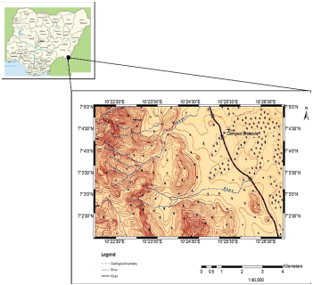
Figure 1. Topographic map of the study area Modified after [4].
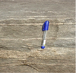
Figure 2. Banded gneiss.

Figure 3. Syeno diorite.
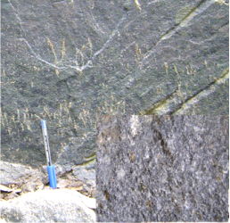
Figure 4. Diorite.
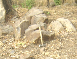
Figure 5. Basalt dyke.
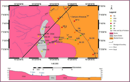
Figure 6. Geological map (with sampling points) of the area.
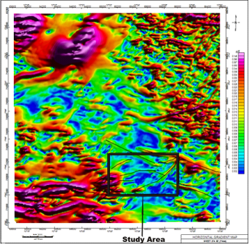
Figure 7. Horizontal Gradient Map of the area.
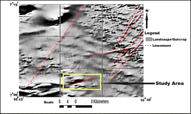
Figure 8. Magnetic Lineament Map of the area.
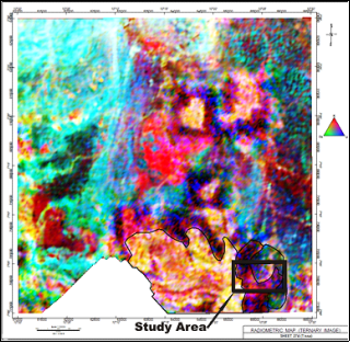
Figure 9. Radiometric Ternary Image.
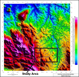
Figure 10. Digital elevation model map of the area.
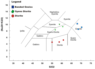
Figure 11. TAS plot for banded gneiss, syeno diorite and diorite after [5].
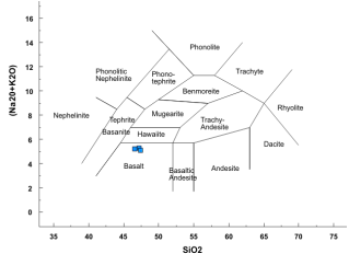
Figure 12. TAS plot for basalt after [5].
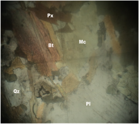
Figure 13. Banded gneiss under cross polar.
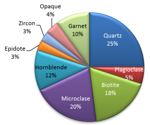
Figure 14. Modal composition of banded gneiss.
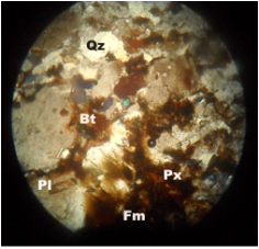
Figure 15. Syeno diorite under cross polar.
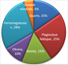
Figure 16. Modal composition of syeno diorite.
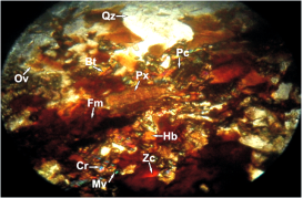
Figure 17. Photomicrograph of diorite under cross polar (x20).
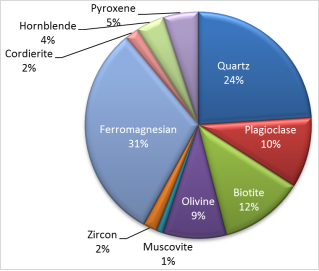
Figure 18. Average modal compositions of diorite.
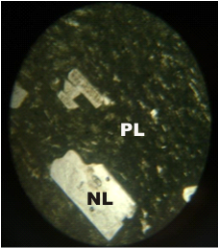
Figure 19. Basalt under cross polar.
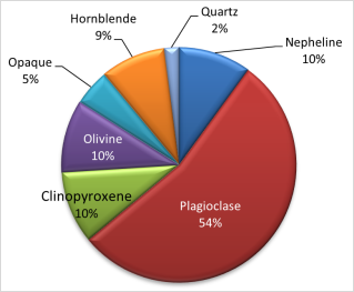
Figure 20. Modal composition of basalt.
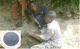
Figure 21. Stream sediments containing ilmenite at River Akpo (insert Panned ilmenite at River Akpo).
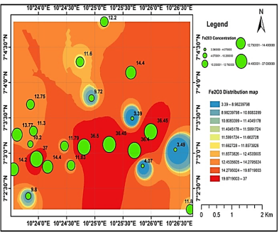
Figure 22. Spatial distribution map of Fe2O3.
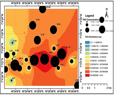
Figure 23. Spatial distribution map of TiO2.
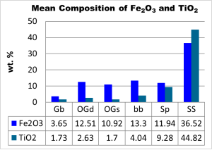
Figure 24. Mean concentration of Fe2O3 and TiO2 (FeTiO3) in iron rich rocks, stream and soil.
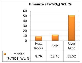
Figure 25. Mean concentration of Ilmenite (FeTiO3).
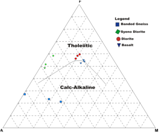
Figure 26. AFM plot for the rocks in the study area after [9].
Information

