Abstract
Urban waterways in the Niger Delta are increasingly exposed to channel siltation, bank erosion, uncontrolled waste deposition, hydraulic scour and progressive loss of channel capacity. These problems are particularly critical where shoreline stabilization must be undertaken concurrently with dredging, reclamation and navigation improvement on weak, saturated sediments. This study presents the geotechnical investigation, design and construction of a gabion-based shoreline protection system implemented as a component of the integrated improvement of Diobu Creek, Port Harcourt, Nigeria. The study combines topographic and bathymetric surveys, tidal observations, three geotechnical boreholes, particle-size analysis, permeability estimation and direct shear testing to establish the engineering conditions controlling shoreline stability and revetment performance. The investigated riverbed comprises approximately 1.2–1.6 m of very soft to soft organic silty clay underlain by predominantly medium-grained, relatively uniform sand extending to at least 12 m below the riverbed. The sand exhibits an estimated hydraulic conductivity of approximately (4.41 × 10⁻³) m/s and an average angle of internal friction of about 34°. These conditions necessitated careful management of saturated sediments during excavation and construction below Low Low Water (LLW). The adopted protection system comprised shoreline sand filling and regrading, excavation of weak foundation sediments, placement of a 0.45 m crushed-stone foundation layer, installation of a high-strength geotextile filter/separator, placement and interconnection of zinc-coated gabion baskets filled with durable crushed rock, and construction of a crest/anchor beam. A 1V:2.5H bank slope was adopted to reduce the potential for instability while providing an appropriate geometry for the gabion revetment. Construction experience demonstrated that the principal geotechnical challenges were instability of saturated soft sediments, localized failure of the regraded sand slope, seepage and piping risks, toe scour, and the need to synchronize excavation and foundation placement with tidal conditions. The study demonstrates that gabion revetments, when integrated with appropriate foundation preparation, geotextile filtration, toe protection and drainage, can provide a flexible and permeable shoreline stabilization solution for urban tidal-creek environments. The findings provide a practical framework for the design and construction of shoreline protection systems in the soft, sediment-dominated environments of the Niger Delta.
Keywords
Diobu Creek, Shoreline Stabilization, Gabion Revetment, Soft Sediment, Geotextile Filter, Reclamation, Niger Delta
1. Introduction
Rivers and tidal creeks constitute important components of the physical, ecological and economic infrastructure of rapidly urbanizing coastal regions. In addition to conveying stormwater and supporting flood regulation, urban waterways provide opportunities for navigation, recreation, fisheries and other socioeconomic activities. Their hydraulic and ecological functions, however, depend strongly on the integrity and stability of their channels and banks
| [4] | Abam, T. K. S and Okagbue, CO. (1986) Construction and Performance of River Bank Protection Structure in the Niger Delta. Bulletin of the Association of Engineering Geology, France, Vol XXIII No 4, pp 499-506. |
| [22] | U.S. Army Corps of Engineers (USACE). (2003). EM 1110-2-1902: Slope Stability. Washington, DC: U.S. Army Corps of Engineers. |
[4, 22]
. Progressive sedimentation, waste accumulation, encroachment, bank erosion and poorly controlled development can alter channel geometry, reduce conveyance capacity and increase the vulnerability of adjoining infrastructure and communities.
These challenges are particularly important in the Niger Delta of Nigeria, where low-lying terrain, highly erodible sediments, extensive tidal waterways and intense human activities create a naturally vulnerable riverine and coastal environment. Earlier investigations demonstrated substantial spatial and temporal variability in shoreline position across the Niger Delta, with extensive sections undergoing either erosion or accretion
| [1] | Abam, T. K. S., Giadom, F. D., & Iduma, R. E. O. (2023). Impact of dredging on coastal infrastructure: Case studies from Okrika and Port-Harcourt, Niger Delta. Journal of Geoscience and Environment Protection, 11(8), 349–362.
https://doi.org/10.4236/gep.2023.118021 |
| [3] | Abam, T. K. S., Gobo, A. E., & Opuaji, T. (2004). Spatial and temporal patterns of coastal erosion in the Niger Delta. Global Journal of Geological Sciences, 2(1), 79–90.
https://doi.org/10.4314/gjgs.v2i1.18684 |
[1, 3]
. More recent investigations similarly demonstrate that shoreline dynamics and coastal vulnerability are influenced by shoreline morphology, elevation, tidal range, wave climate, sea-level rise and anthropogenic disturbance
| [8] | Cheong, S.-M., Silliman, B., Wong, P. P., Van Wesenbeeck, B., Kim, C.-K., & Guannel, G. (2013). Coastal adaptation with ecological engineering. Nature Climate Change, 3(9), 787–791. https://doi.org/10.1038/nclimate1854 |
| [18] | Osondu, I., Imoni, O., Chukwuemeka, P., et al. (2025). Machine learning-based shoreline change prediction and erosion analysis: A case study of Ogu/Bolo, Nigeria. Discover Civil Engineering, 2.
https://doi.org/10.1007/s44290-025-00396-5 |
| [19] | Sharma, S., Goff, J., Cebrian, J., & Ferraro, C. (2016). A hybrid shoreline stabilization technique: Impact of modified intertidal reefs on marsh expansion and nekton habitat in the northern Gulf of Mexico. Ecological Engineering, 90, 352–360.
https://doi.org/10.1016/j.ecoleng.2016.02.003 |
[8, 18, 19]
.
The vulnerability of the Niger Delta is further amplified by its low-lying coastal morphology and sensitivity to relative sea-level change. A recent assessment reported that approximately 40.1–58.9% of the Niger Delta coastline falls within high or very-high vulnerability classes, depending on the shoreline-change method and digital elevation model employed
| [8] | Cheong, S.-M., Silliman, B., Wong, P. P., Van Wesenbeeck, B., Kim, C.-K., & Guannel, G. (2013). Coastal adaptation with ecological engineering. Nature Climate Change, 3(9), 787–791. https://doi.org/10.1038/nclimate1854 |
[8]
. This finding emphasizes the importance of site-specific investigations rather than reliance solely on regional-scale vulnerability indices when selecting and designing shoreline protection measures.
Diobu Creek is one of the important urban drainage and waterway systems within Port Harcourt. The creek traverses highly developed parts of the metropolis, including areas associated with residential, commercial, mechanical and market activities. The catchment has experienced prolonged human disturbance, including uncontrolled waste disposal and sediment accumulation within the channel. The resulting reduction in channel capacity and modification of the hydraulic cross-section can increase flow velocities locally and promote bank erosion, particularly at bends, constrictions and other hydraulically active sections
| [2] | Abam, Tamunoene Kingdom Simeon, Tamunotonye Oba and Robert Egwu Otu Iduma (2023) Impact of Dredging the Okpoka River on Coastal Infrastructure: A Case Study of the Akpajo Bridge. Global Research in Environment and Sustainability. August 2023, Vol. 1, No. 6, pp. 97-109. |
| [22] | U.S. Army Corps of Engineers (USACE). (2003). EM 1110-2-1902: Slope Stability. Washington, DC: U.S. Army Corps of Engineers. |
[2, 22]
.
The problem is therefore not simply one of shoreline erosion. In an urban creek undergoing dredging and reclamation, shoreline protection must simultaneously address channel geometry, foundation conditions, hydraulic loading, sediment transport, bank stability, drainage, toe protection and constructability. Established coastal engineering guidance emphasizes the integration of these factors in the planning and design of shore-protection works
| [21] | U.S. Army Corps of Engineers (USACE). (2002). EM 1110-2-1100: Coastal Engineering Manual. Washington, DC: U.S. Army Corps of Engineers. |
| [22] | U.S. Army Corps of Engineers (USACE). (2003). EM 1110-2-1902: Slope Stability. Washington, DC: U.S. Army Corps of Engineers. |
[21, 22]
. This is particularly important where the riverbed consists of very soft saturated sediments overlying relatively permeable sand. Excavation of the soft layer can cause instability and local sloughing, while placement of reclamation fill can generate excess pore-water pressures and induce deformation of the newly formed bank. A successful shoreline protection scheme must consequently be compatible with both the hydraulic environment and the geotechnical characteristics of the foundation.
A variety of shoreline protection measures are available, ranging from nature-based and bioengineered approaches to hard structural systems such as riprap, rock bunds, sheet-pile walls, seawalls, quay walls, retaining structures and gabion revetments
| [4] | Abam, T. K. S and Okagbue, CO. (1986) Construction and Performance of River Bank Protection Structure in the Niger Delta. Bulletin of the Association of Engineering Geology, France, Vol XXIII No 4, pp 499-506. |
| [21] | U.S. Army Corps of Engineers (USACE). (2002). EM 1110-2-1100: Coastal Engineering Manual. Washington, DC: U.S. Army Corps of Engineers. |
| [22] | U.S. Army Corps of Engineers (USACE). (2003). EM 1110-2-1902: Slope Stability. Washington, DC: U.S. Army Corps of Engineers. |
[4, 21, 22]
. Nature-based approaches are increasingly advocated because of their potential to preserve ecological functions and improve shoreline resilience
| [6] | Bilkovic, D. M., Mitchell, M. M., La Peyre, M. K., & Toft, J. D. (Eds.). (2017). Living shorelines: The science and management of nature-based coastal protection. CRC Press.
https://doi.org/10.1201/9781315151465 |
| [16] | Nesshöver, C., Assmuth, T., Irvine, K. N., Rusch, G. M., Waylen, K. A., Delbaere, B., et al. (2017). The science, policy and practice of nature-based solutions: An interdisciplinary perspective. Science of the Total Environment, 579, 1215–1227.
https://doi.org/10.1016/j.scitotenv.2016.11.106 |
| [17] | Nnam, V. C., Odumosu, J. O., Ikwueze, U., & Lamidi, S. (2026). Deep learning-enhanced shoreline dynamics and vulnerability assessment in Niger Delta area of Nigeria. Scientific Reports, 16, 12595. |
[6, 16, 17]
. Living-shoreline research has demonstrated the capacity of vegetation and ecological engineering approaches to provide habitat and shoreline stabilization benefits
| [5] | Abija, F. A., Abam, T. K. S., Teme, S. C., & Eze, C. L. (2020/2021). Relative sea level rise, coastline variability and coastal erosion in the Niger Delta, Nigeria: Implications for climate change adaptation and coastal zone management. Journal of Earth Science & Climatic Change, 11(9). |
| [15] | Narayan, S., Beck, M. W., Reguero, B. G., Losada, I. J., Van Wesenbeeck, B., Pontee, N., et al. (2016). The effectiveness, costs and coastal protection benefits of natural and nature-based defenses. PLoS ONE, 11, e0154735.
https://doi.org/10.1371/journal.pone.0154735 |
[5, 15]
while studies of hardened shorelines have documented potential ecological consequences associated with replacing soft, dynamic shore margins with rigid structures
| [9] | Davidson, M. A., Splinter, K. D., & Turner, I. L. (2013). A simple equilibrium model for predicting shoreline change. Coastal Engineering, 73, 191–202.
https://doi.org/10.1016/j.coastaleng.2012.11.002 |
| [12] | Gittman, R. K., Scyphers, S. B., Smith, C. S., Neylan, I. P., & Grabowski, J. H. (2016). Ecological consequences of shoreline hardening: A meta-analysis. BioScience, 66, 763–773.
https://doi.org/10.1093/biosci/biw091 |
| [15] | Narayan, S., Beck, M. W., Reguero, B. G., Losada, I. J., Van Wesenbeeck, B., Pontee, N., et al. (2016). The effectiveness, costs and coastal protection benefits of natural and nature-based defenses. PLoS ONE, 11, e0154735.
https://doi.org/10.1371/journal.pone.0154735 |
[9, 12, 15]
.
Nevertheless, soft engineering is not universally adequate. In densely developed urban waterways, where land availability is restricted and the bank must accommodate reclamation, navigation or infrastructure, a structural revetment may be necessary. In such circumstances, the objective should not merely be to construct the strongest possible structure, but to develop a system that is sufficiently stable while remaining hydraulically compatible with the river environment. Gabions possess several characteristics that make them attractive for shoreline stabilization. Their permeability facilitates drainage and reduces the potential development of excessive hydrostatic pressure behind the revetment, while their flexibility allows accommodation of limited differential deformation. Their rough and porous rock surface can also contribute to hydraulic energy dissipation. However, gabion systems are not inherently immune to failure, and their performance depends strongly on foundation preparation, toe stability, rock gradation, mesh durability, filtration, drainage, slope geometry and protection against scour and outflanking
| [21] | U.S. Army Corps of Engineers (USACE). (2002). EM 1110-2-1100: Coastal Engineering Manual. Washington, DC: U.S. Army Corps of Engineers. |
| [22] | U.S. Army Corps of Engineers (USACE). (2003). EM 1110-2-1902: Slope Stability. Washington, DC: U.S. Army Corps of Engineers. |
[21, 22]
.
The design of a shoreline revetment therefore requires integration of hydraulic and geotechnical considerations. Established coastal engineering guidance emphasizes the need to consider coastal processes, wave and current action, foundation conditions, drainage, scour and structural stability in the design of shore protection works
| [21] | U.S. Army Corps of Engineers (USACE). (2002). EM 1110-2-1100: Coastal Engineering Manual. Washington, DC: U.S. Army Corps of Engineers. |
| [11] | Gittman, R. K., & Scyphers, S. B. (2017). The cost of coastal protection: A comparison of shore stabilization approaches. Shore & Beach, 85, 19–24. |
[21, 11]
. For slopes founded on soft or weak materials, stability assessment must also consider soil strength, pore-water pressure, seepage, geometry and imposed loads rather than relying only on comparison between slope angle and soil friction angle.
1.1. Knowledge Gap
Although considerable research has addressed shoreline change, coastal vulnerability, nature-based protection and the ecological consequences of shoreline hardening, much of the existing Niger Delta literature has concentrated on regional shoreline migration, remote sensing, vulnerability mapping and climate-related coastal hazards
| [1] | Abam, T. K. S., Giadom, F. D., & Iduma, R. E. O. (2023). Impact of dredging on coastal infrastructure: Case studies from Okrika and Port-Harcourt, Niger Delta. Journal of Geoscience and Environment Protection, 11(8), 349–362.
https://doi.org/10.4236/gep.2023.118021 |
| [8] | Cheong, S.-M., Silliman, B., Wong, P. P., Van Wesenbeeck, B., Kim, C.-K., & Guannel, G. (2013). Coastal adaptation with ecological engineering. Nature Climate Change, 3(9), 787–791. https://doi.org/10.1038/nclimate1854 |
| [18] | Osondu, I., Imoni, O., Chukwuemeka, P., et al. (2025). Machine learning-based shoreline change prediction and erosion analysis: A case study of Ogu/Bolo, Nigeria. Discover Civil Engineering, 2.
https://doi.org/10.1007/s44290-025-00396-5 |
| [19] | Sharma, S., Goff, J., Cebrian, J., & Ferraro, C. (2016). A hybrid shoreline stabilization technique: Impact of modified intertidal reefs on marsh expansion and nekton habitat in the northern Gulf of Mexico. Ecological Engineering, 90, 352–360.
https://doi.org/10.1016/j.ecoleng.2016.02.003 |
[1, 8, 18, 19]
. These approaches provide valuable regional information but offer limited site-specific evidence regarding the geotechnical and construction controls governing the performance of shoreline protection structures within urban tidal creeks.
There is consequently a relative shortage of documented engineering case studies that integrate:
1) detailed sub-riverbed characterization;
2) soft-sediment foundation conditions;
3) reclamation and bank regrading;
4) tidal constraints on below-water construction;
5) geotextile filtration and separation;
6) gabion foundation and toe preparation;
7) slope geometry and stability;
8) rock gradation and mesh compatibility; and
9) practical construction responses to saturated, unstable riverbank sediments.
This gap is important because a shoreline protection structure that performs satisfactorily in a wave-dominated open coast may not necessarily exhibit the same behaviour in a confined, urban tidal creek where bank erosion is controlled by a combination of tidal currents, rainfall runoff, channel hydraulics, sediment deposition, seepage and human disturbance. The present study addresses this gap by documenting the geotechnical investigation, design rationale and construction experience associated with gabion shoreline stabilization at Diobu Creek.
1.2. Aim and Objectives
The primary aim of this study is to evaluate the geotechnical basis and construction performance of a gabion revetment developed for shoreline stabilization as part of the integrated improvement of Diobu Creek, Port Harcourt.
The specific objectives are to:
1) characterize the sub-riverbed geological and geotechnical conditions along the protected shoreline;
2) establish the engineering properties of the foundation and reclamation materials;
3) assess the implications of soft saturated sediments for excavation, foundation preparation and bank stability;
4) develop a practical shoreline protection system incorporating sand reclamation, geotextile filtration, crushed-stone foundation support and gabion revetment;
5) examine the construction challenges associated with tidal and below-water works; and
6) evaluate the suitability of gabion revetments for shoreline stabilization in soft-sediment urban waterways of the Niger Delta.
The study contributes a site-specific engineering framework that links geotechnical characterization with shoreline protection design and construction practice, thereby complementing the predominantly regional-scale shoreline-change and vulnerability literature on the Niger Delta.
2. Methodology
2.1. Study Approach
The study adopted an integrated field and laboratory investigation combining topographic and bathymetric surveys, tidal observations, geotechnical drilling, soil sampling, laboratory testing, engineering interpretation and construction monitoring. The investigation was designed to establish the existing shoreline geometry, riverbed configuration, subsoil stratigraphy and engineering properties required for the design and construction of the shoreline protection works.
The shoreline protection formed part of an integrated improvement programme for Diobu Creek involving dredging, reclamation, navigation-path development and stabilization of selected eroding sections of the riverbank. The methodology therefore considered not only the resistance of the revetment to hydraulic action but also its compatibility with the dredging and reclamation activities.
2.2. Topographic, Bathymetric and Tidal Surveys
Topographic surveys were undertaken to establish the existing elevations and configuration of the riverbank. Cross-sectional information was used to define the existing bank profile and estimate the quantities of sand required for filling, nourishment and regrading.
Bathymetric surveys were conducted to establish the geometry and depth of the river channel surrounding the proposed protection area. The bathymetric information was used in conjunction with the topographic survey to develop the riverbank and riverbed profiles required for the design and construction of the revetment.
Tidal observations were incorporated into construction planning. High-water and Low Low Water (LLW) levels were established to define the vertical reference system and identify the periods during which foundation excavation and placement of the stone footing could be undertaken most effectively. The tidal cycle was particularly important because portions of the foundation works were located below LLW and therefore required careful sequencing to minimize inundation and instability.
2.3. Geotechnical Investigation
Three boreholes were drilled within the channel area to a depth of approximately 12 m below the existing riverbed. The investigation was undertaken to:
1) determine the sub-riverbed stratigraphy;
2) identify weak or compressible foundation materials;
3) establish the distribution and engineering characteristics of the sand deposit;
4) obtain representative samples for laboratory testing; and
5) develop a conceptual sub-riverbed model for dredging and shoreline protection activities.
The borehole information was correlated to establish the degree of lateral uniformity of the riverbed deposits. Particular attention was given to the thickness and condition of the near-surface soft sediments because these materials directly influenced the excavation method and foundation treatment.
2.4. Laboratory Testing
Representative sand samples recovered from the boreholes were subjected to particle-size distribution and direct shear testing. Particle-size analysis was used to classify the sand and assess its drainage characteristics. The coefficient of hydraulic conductivity was estimated from the effective grain size using the empirical Hazen relationship, subject to the limitations associated with its application to relatively clean, uniformly graded sands:
k = CH D²₁₀
where k is hydraulic conductivity, C
H is Hazen's empirical coefficient and D
10 is the effective grain diameter. The numerical value of C
H depends on the unit system and the characteristics of the soil; therefore, the units used in the calculation should be explicitly stated
| [7] | Bilkovic, D. M., Mitchell, M. M., Mason, P., & Duhring, K. (2016). The role of living shorelines as estuarine habitat conservation strategies. Coastal Management, 44(3), 161–174. https://doi.org/10.1080/08920753.2016.1160201 |
| [13] | Lawless, A. S., & Seitz, R. D. (2014). Effects of shoreline stabilization and environmental variables on benthic infaunal communities in the Lynnhaven River System of Chesapeake Bay. Journal of Experimental Marine Biology and Ecology, 457, 41–50. https://doi.org/10.1016/j.jembe.2014.03.010 |
[7, 13]
.
Direct shear testing was conducted to determine the shear strength characteristics of the sand. The peak shear resistance was interpreted using the Mohr-Coulomb relationship
| [7] | Bilkovic, D. M., Mitchell, M. M., Mason, P., & Duhring, K. (2016). The role of living shorelines as estuarine habitat conservation strategies. Coastal Management, 44(3), 161–174. https://doi.org/10.1080/08920753.2016.1160201 |
| [20] | U.S. Army Corps of Engineers (USACE). (1995). EM 1110-2-1614: Design of Coastal Revetments, Seawalls, and Bulkheads. Washington, DC: U.S. Army Corps of Engineers. |
[7, 20]
:
τf = c′ + σ′ tan φ′
where 𝝉 is shear strength, (c') is effective cohesion, 𝝈’ is effective normal stress and 𝝓’ is the effective angle of internal friction.
The resulting soil parameters were used in assessing the suitability of the material for the proposed shoreline geometry and revetment system.
2.5. Shoreline Protection Design and Construction
The shoreline protection system was designed as a sloping gabion revetment incorporating:
1) sand filling and regrading of the existing riverbank;
2) excavation/removal of the very soft to soft near-surface material at the foundation zone;
3) placement of a crushed-stone foundation layer;
4) installation of a woven geotextile separator/filter;
5) placement and interconnection of zinc-coated gabion baskets;
6) filling of the baskets with durable angular crushed rock;
7) provision of additional filtration/separation behind the gabion system; and
8) construction of a reinforced concrete crest/anchor beam.
The regraded shoreline was constructed at approximately 1V:2.5H. This corresponds to a geometric inclination of approximately 21.8° to the horizontal. The measured sand friction angle of approximately 34° indicates that the selected slope angle was less than the laboratory-measured friction angle. However, this comparison is only a preliminary screening consideration and should not be interpreted as a formal factor of safety because saturated slope stability also depends on pore-water pressure, seepage, unit weight, loading and potential failure-surface geometry
| [10] | Dugan, J. E., Emery, K. A., Alber, M., Alexander, C. R., Byers, J. E., Gehman, A. M., ... & Scyphers, S. B. (2018). Generalizing ecological effects of shoreline armoring across soft-sediment environments. Estuaries and Coasts, 41(Suppl 1), S180–S196. https://doi.org/10.1007/s12237-017-0254-x |
| [23] | Vinayaraj, P., Johnson, G., Udhaba Dora, G., Sajiv Philip, C., Sanil Kumar, V., & Gowthaman, R. (2011). Quantitative estimation of coastal changes along selected locations of Karnataka, India: A GIS and remote sensing approach. International Journal of Geosciences, 2(4), 385–393.
https://doi.org/10.4236/ijg.2011.24042 |
[10, 23]
.
A crushed-stone foundation layer approximately 0.45 m thick was provided at the toe to improve bearing conditions, provide a stable working platform and reduce direct contact between the gabion structure and the very soft riverbed sediments.
A high-strength woven geotextile was placed beneath and behind the revetment to perform separation and filtration functions. The selected material had a mass per unit area of approximately 350 g/m², nominal thickness of about 1.17 mm, mean tensile strength of approximately 50 kN/m, static puncture resistance of approximately 6,700 N, characteristic opening size of approximately 0.24 mm and normal permeability of approximately 13.6 mm/s.
The geotextile was carefully anchored and trimmed to prevent exposure and displacement. The gabion baskets were assembled, interconnected and filled with clean, hard angular crushed rock. Larger rock pieces were preferentially used at the toe to increase resistance to displacement and provide additional toe stability.
3. Results and Discussion
3.1. Existing Shoreline and Bathymetric Conditions
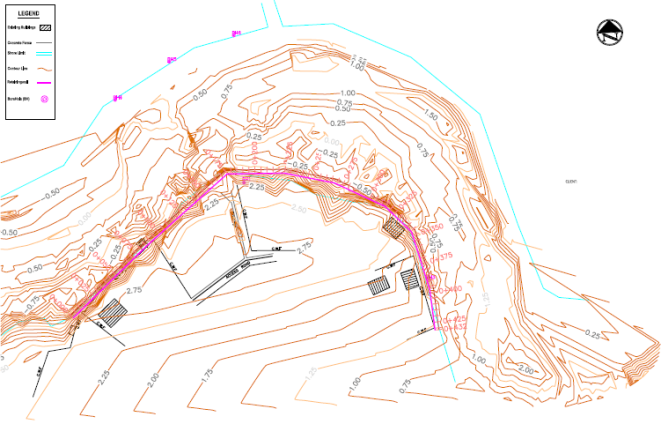
Figure 1. Topographic and Bathymetric surveys of river channel area.
The topographic and bathymetric surveys (
Figure 1) established the existing geometry of the shoreline and river channel and provided the basis for determining the extent of bank regrading, reclamation and foundation excavation. The surveys also demonstrated the importance of integrating shoreline protection with channel improvement because stabilization of an eroding bank without addressing channel capacity and sedimentation would not necessarily provide a sustainable solution.
The observed accumulation of heterogeneous debris within the channel was consistent with the long-term urban disturbance of the creek. Such material can locally alter hydraulic roughness, flow direction and sediment deposition, thereby generating spatially variable erosion and deposition patterns. Consequently, the shoreline protection system was designed as part of a wider river improvement scheme rather than as an isolated erosion-control intervention.
This approach is consistent with the broader understanding of Niger Delta waterways as highly dynamic systems in which shoreline position is influenced by hydraulic processes, sediment availability, tidal conditions and human intervention. Regional shoreline studies have demonstrated considerable spatial variability in erosion and accretion throughout the Niger Delta.
3.2. Sub-Riverbed Stratigraphy
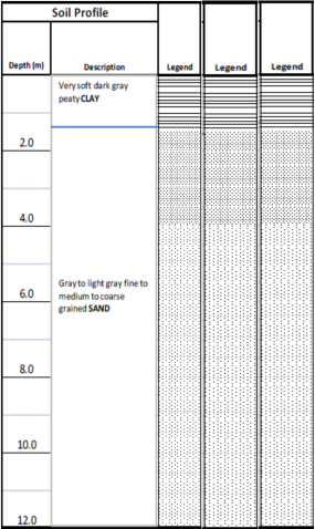
The three boreholes revealed a relatively consistent stratigraphic sequence (
Figure 2). The uppermost layer comprised very soft to soft organic silty clay with thicknesses ranging from approximately 1.2 to 1.6 m. This material was underlain by grey to light-grey, medium-grained sand that continued to the termination depth of approximately 12 m below the riverbed.
Figure 2. Composite litholog of borings in River channels.
The relatively uniform stratigraphy is important from a design perspective because the weak upper layer represents the principal geotechnical constraint to foundation construction. It’s very soft condition, high water content and proximity to the tidal water surface make it susceptible to local sloughing and deformation during excavation.
In contrast, the underlying sand provides a significantly more favourable drainage and shear-strength environment. The sand therefore constituted an appropriate material for supporting the treated foundation zone once the most problematic near-surface soft sediments had been appropriately managed.
3.3. Particle-Size Distribution and Hydraulic Conductivity
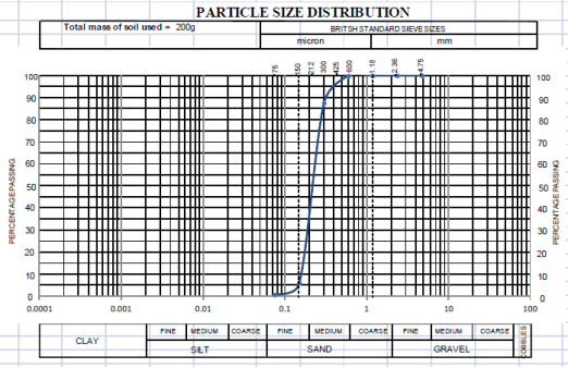
Particle-size analysis indicates that the riverbed sand is predominantly medium-grained and relatively well sorted/uniformly graded (
Figure 3). The estimated hydraulic conductivity of approximately 4.41 × 10
-3 m/s indicates relatively high permeability.
The high permeability has two contrasting implications for the project. On one hand, it promotes rapid drainage and dissipation of water pressures within the sandy foundation and reclamation materials. On the other hand, hydraulic gradients generated during tidal fluctuations, rainfall infiltration and bank drainage may promote migration of fine particles where an appropriate filter/separator is not provided.
The use of geotextile filtration was therefore critical. The geotextile serves to retain the fine soil particles while allowing water to pass through, thereby reducing the potential for internal erosion and loss of the supporting soil through the voids in the gabion rock.
Figure 3. Particle size distribution of sandbed materials.
3.4. Shear Strength and Bank-Slope Selection
Direct shear testing produced an average angle of internal friction of approximately 34°. This value indicates substantial frictional resistance characteristic of dense-to-medium-density granular materials and supports the use of a relatively stable sloping revetment geometry.
The selected 1V:2.5H slope corresponds to approximately 21.8° and is therefore considerably flatter than the measured friction angle. This geometric relationship provides a favourable preliminary condition for stability. However, the observed construction-stage failures demonstrated why the friction angle alone cannot be used to establish overall slope stability.
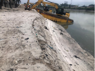
During periods of heavy rainfall and saturation, portions of the regraded sand slope experienced localized slip failures (
Figure 4). These failures are attributed to transient increases in pore-water pressure and reduction in effective stress within the newly placed/regraded material. The occurrence of such failures highlights the importance of considering transient groundwater and seepage conditions in addition to drained shear strength.
Figure 4. Slip failures in formed sand slope.
Where localized failures occurred, the affected zones were excavated/treated with crushed stone and reinstated to restore the design profile. The practical response demonstrates that construction-stage stability may be more critical than the long-term drained condition, particularly where reclamation materials are placed rapidly adjacent to a tidal water body.
3.5. Foundation Treatment and Construction Below LLW
The very soft to soft upper riverbed layer created the most significant construction challenge. Excavation in saturated soft sediments may result in temporary instability because excavation reduces confinement while seepage and tidal fluctuations influence effective stress and pore-water conditions. Consequently, construction-stage stability must be evaluated separately from long-term operational stability
| [20] | U.S. Army Corps of Engineers (USACE). (1995). EM 1110-2-1614: Design of Coastal Revetments, Seawalls, and Bulkheads. Washington, DC: U.S. Army Corps of Engineers. |
| [23] | Vinayaraj, P., Johnson, G., Udhaba Dora, G., Sajiv Philip, C., Sanil Kumar, V., & Gowthaman, R. (2011). Quantitative estimation of coastal changes along selected locations of Karnataka, India: A GIS and remote sensing approach. International Journal of Geosciences, 2(4), 385–393.
https://doi.org/10.4236/ijg.2011.24042 |
[20, 23]
.
A practical construction response involved controlled mixing/treatment of the soft sediment with sand and subsequent placement of approximately 0.45 m of crushed stone to establish a stable foundation platform. The stone layer served multiple functions: it improved the working surface, distributed the structural load, provided drainage and reduced the likelihood of direct settlement or deformation of the gabion toe into the weak sediment.
The experience emphasizes the need to distinguish between the ultimate geotechnical capacity of the completed structure and temporary construction-stage stability. In tidal environments, the latter may control the sequence and timing of works even where the final structure has an adequate long-term stability margin.
3.6. Function of the Geotextile Filter
The geotextile constituted an integral component of the revetment system rather than merely an accessory material. Its principal functions were separation and filtration: retaining the underlying soil while permitting seepage water to pass through the system. Effective filter design must balance soil retention, hydraulic permeability and resistance to clogging and mechanical damage
| [14] | Mitchell, M., & Bilkovic, D. (2019). Embracing dynamic design for climate-resilient living shorelines. Journal of Applied Ecology, 56, 1099–1105.
https://doi.org/10.1111/1365-2664.13371 |
| [21] | U.S. Army Corps of Engineers (USACE). (2002). EM 1110-2-1100: Coastal Engineering Manual. Washington, DC: U.S. Army Corps of Engineers. |
[14, 21]
.
This function is particularly important because the underlying sand is relatively permeable and the upper riverbed contains fine-grained soft sediment. Without adequate filtration, cyclic water-level changes could promote internal erosion, piping and progressive loss of the soil supporting the revetment.
The filter layer also improves compatibility between the fine-grained foundation/reclamation material and the relatively coarse gabion fill. The selected geotextile properties provided an appropriate combination of filtration, permeability and mechanical resistance for the intended application.
3.7. Gabion Revetment Performance and Structural Behaviour
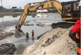
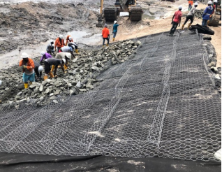
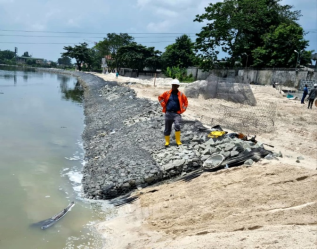
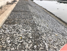
Figures 5 to 8 show the sequence of installation of the Gabion Revetment. The completed gabion revetment produced a flexible, permeable and relatively rough shoreline surface
| [21] | U.S. Army Corps of Engineers (USACE). (2002). EM 1110-2-1100: Coastal Engineering Manual. Washington, DC: U.S. Army Corps of Engineers. |
| [22] | U.S. Army Corps of Engineers (USACE). (2003). EM 1110-2-1902: Slope Stability. Washington, DC: U.S. Army Corps of Engineers. |
[21, 22]
. Unlike an impermeable concrete wall, the gabion system allows water to pass through the structure and dissipates part of the hydraulic energy through the voids and frictional resistance within the rock mass.
Figure 5. Placement of crushed stone footing.
Figure 6. Filling of gabion gauges with crushed stones.
Figure 7. Partly constructed Gabion revetment.
Figure 8. Fully constructed shoreline protection.
The flexibility of the baskets is also advantageous in a foundation environment where some differential movement may occur. Rather than requiring the foundation to remain perfectly rigid, a gabion revetment can accommodate limited deformation without immediate loss of structural continuity.
The performance of the system nevertheless depends strongly on the integrity of the mesh, quality and gradation of the rock fill, foundation condition and toe protection. The use of zinc-coated steel mesh was intended to improve resistance to corrosion, while clean, hard angular rock provides improved interlocking compared with rounded particles.
These characteristics are consistent with the broader engineering rationale for permeable rock-based shoreline protection. However, research on shoreline armouring also demonstrates that fixed structures can produce localized changes in sediment transport and ecological conditions. Consequently, gabions should be considered as part of an adaptive shoreline-management strategy rather than as a universal substitute for natural or nature-based stabilization.
3.8. Toe Scour and Outflanking
Although the completed revetment was structurally stable, two long-term mechanisms require continued attention: toe scour and outflanking.
Toe scour represents a major failure mechanism for rock-armoured and revetment structures because removal of supporting sediment can undermine the armour layer and reduce overall stability. Toe structures and underlying filter systems are therefore important components of revetment design
| [21] | U.S. Army Corps of Engineers (USACE). (2002). EM 1110-2-1100: Coastal Engineering Manual. Washington, DC: U.S. Army Corps of Engineers. |
| [4] | Abam, T. K. S and Okagbue, CO. (1986) Construction and Performance of River Bank Protection Structure in the Niger Delta. Bulletin of the Association of Engineering Geology, France, Vol XXIII No 4, pp 499-506. |
[21, 4]
.
Terminal transitions between protected and unprotected shorelines should be carefully keyed into the adjoining bank because erosion may concentrate at structural discontinuities
| [21] | U.S. Army Corps of Engineers (USACE). (2002). EM 1110-2-1100: Coastal Engineering Manual. Washington, DC: U.S. Army Corps of Engineers. |
[21]
.
These considerations are consistent with established coastal revetment design practice
| [22] | U.S. Army Corps of Engineers (USACE). (2003). EM 1110-2-1902: Slope Stability. Washington, DC: U.S. Army Corps of Engineers. |
| [23] | Vinayaraj, P., Johnson, G., Udhaba Dora, G., Sajiv Philip, C., Sanil Kumar, V., & Gowthaman, R. (2011). Quantitative estimation of coastal changes along selected locations of Karnataka, India: A GIS and remote sensing approach. International Journal of Geosciences, 2(4), 385–393.
https://doi.org/10.4236/ijg.2011.24042 |
[22, 23]
, which emphasizes foundation, toe and terminal stability in addition to the stability of the main revetment face.
3.9. Environmental and Management Implications
The gabion revetment offers several advantages in the context of Diobu Creek. Its permeable structure maintains hydraulic connectivity between the bank and channel, while its rough surface can reduce direct reflection of hydraulic energy relative to a rigid impermeable wall. The structure also has a relatively small visual footprint compared with massive concrete retaining structures.
Nevertheless, the ecological consequences of shoreline hardening should not be overlooked. Shoreline armouring can modify intertidal habitat, sediment dynamics and benthic communities
| [10] | Dugan, J. E., Emery, K. A., Alber, M., Alexander, C. R., Byers, J. E., Gehman, A. M., ... & Scyphers, S. B. (2018). Generalizing ecological effects of shoreline armoring across soft-sediment environments. Estuaries and Coasts, 41(Suppl 1), S180–S196. https://doi.org/10.1007/s12237-017-0254-x |
| [12] | Gittman, R. K., Scyphers, S. B., Smith, C. S., Neylan, I. P., & Grabowski, J. H. (2016). Ecological consequences of shoreline hardening: A meta-analysis. BioScience, 66, 763–773.
https://doi.org/10.1093/biosci/biw091 |
| [15] | Narayan, S., Beck, M. W., Reguero, B. G., Losada, I. J., Van Wesenbeeck, B., Pontee, N., et al. (2016). The effectiveness, costs and coastal protection benefits of natural and nature-based defenses. PLoS ONE, 11, e0154735.
https://doi.org/10.1371/journal.pone.0154735 |
[10, 12, 15]
. Accordingly, hard stabilization should be limited to locations where it is technically necessary, while natural or vegetated shoreline treatments should be maintained where space and hydraulic conditions permit
| [4] | Abam, T. K. S and Okagbue, CO. (1986) Construction and Performance of River Bank Protection Structure in the Niger Delta. Bulletin of the Association of Engineering Geology, France, Vol XXIII No 4, pp 499-506. |
| [15] | Narayan, S., Beck, M. W., Reguero, B. G., Losada, I. J., Van Wesenbeeck, B., Pontee, N., et al. (2016). The effectiveness, costs and coastal protection benefits of natural and nature-based defenses. PLoS ONE, 11, e0154735.
https://doi.org/10.1371/journal.pone.0154735 |
[4, 15]
.
The Diobu Creek intervention demonstrates the value of integrating dredging, reclamation, navigation improvement and shoreline protection. Such integration reduces the likelihood that a locally stable revetment will subsequently be undermined by an altered channel configuration.
3.10. Maintenance and Long-Term Monitoring
Periodic inspection and monitoring are essential because mesh deterioration, rock displacement, toe scour, debris accumulation and localized erosion can progressively reduce revetment performance
| [21] | U.S. Army Corps of Engineers (USACE). (2002). EM 1110-2-1100: Coastal Engineering Manual. Washington, DC: U.S. Army Corps of Engineers. |
| [22] | U.S. Army Corps of Engineers (USACE). (2003). EM 1110-2-1902: Slope Stability. Washington, DC: U.S. Army Corps of Engineers. |
[21, 22]
. Particular attention should be paid to the toe, terminal sections, crest, joints between baskets and areas where the revetment interfaces with unprotected shoreline.
Monitoring should ideally include repeat topographic/bathymetric surveys, photographic inspection, measurement of localized scour and assessment of basket integrity. Where practical, repeat surveys should be linked to tidal stages to improve comparison between monitoring epochs.
The monitoring programme should also examine whether the intervention produces unexpected erosion immediately downstream or at the ends of the protected section. This is important because shoreline stabilization may redistribute rather than eliminate sediment transport processes.
4. Conclusion
The integrated improvement of Diobu Creek demonstrates that effective shoreline stabilization in an urban tidal waterway requires the integration of hydraulic, geotechnical and construction considerations. The investigation established a relatively uniform sub-riverbed sequence comprising approximately 1.2–1.6 m of very soft to soft organic silty clay overlying medium-grained sand extending to at least 12 m below the riverbed. The soft upper layer represented the principal foundation and construction challenge, while the underlying sand provided a more favourable bearing and drainage environment.
Laboratory testing indicated an average sand friction angle of approximately 34° and an estimated hydraulic conductivity of about 4.41 × 10⁻³ m/s. These characteristics supported the adoption of a sloping revetment, but the construction-stage instability of saturated sand demonstrated that slope geometry alone is insufficient for evaluating stability. The behaviour of the regraded shoreline was strongly influenced by rainfall, saturation, pore-water pressure and construction sequencing.
The adopted protection system, comprising sand filling and regrading, treatment of weak foundation materials, crushed-stone foundation support, geotextile filtration and separation, zinc-coated gabion baskets filled with durable angular rock, and crest/anchor-beam restraint, provided a practical solution to the combined requirements of erosion protection and reclamation. The geotextile was particularly important in preventing soil migration through the gabion voids while maintaining drainage and hydraulic continuity.
The principal engineering lesson from the project is that the performance of a gabion revetment is governed not only by the gabion baskets themselves but by the soil–filter–rock–foundation system as a whole. Adequate toe treatment, filtration, drainage, slope geometry, foundation preparation and construction sequencing are essential to long-term performance. Particular attention should also be given to localized scour and outflanking at the ends of the protected shoreline.
Gabion revetments are therefore considered suitable for selected sections of soft-sediment urban waterways in the Niger Delta where structural protection is required and where their flexibility, permeability and constructability provide advantages over more rigid shoreline systems. However, they should not be regarded as a universal solution. Their application should be guided by site-specific geotechnical and hydraulic investigations and complemented, where feasible, by natural or nature-based shoreline measures.
For Diobu Creek, the integration of dredging, reclamation, navigation improvement and shoreline stabilization provides a more comprehensive management approach than isolated erosion control. Long-term success will depend on continued maintenance of the gabion system, periodic bathymetric and shoreline surveys, control of waste deposition and monitoring of scour and erosion at the protected/unprotected shoreline transitions. The study provides a practical engineering reference for similar shoreline stabilization projects within the soft, saturated and hydraulically dynamic environments of the Niger Delta.
Author Contributions
Tamunoene Kingdom Simeon Abam: Conceptualization, Methodology, Investigation, Formal Analysis and Writing – Original Draft; Benjamin Stephen Udota: Conceptualization, Supervision, Resources, Data curation.
Acknowledgement
The authors are grateful to the Bureau for Special Projects, Rivers State Government for the opportunity to participate in the project.
References
| [1] |
Abam, T. K. S., Giadom, F. D., & Iduma, R. E. O. (2023). Impact of dredging on coastal infrastructure: Case studies from Okrika and Port-Harcourt, Niger Delta. Journal of Geoscience and Environment Protection, 11(8), 349–362.
https://doi.org/10.4236/gep.2023.118021
|
| [2] |
Abam, Tamunoene Kingdom Simeon, Tamunotonye Oba and Robert Egwu Otu Iduma (2023) Impact of Dredging the Okpoka River on Coastal Infrastructure: A Case Study of the Akpajo Bridge. Global Research in Environment and Sustainability. August 2023, Vol. 1, No. 6, pp. 97-109.
|
| [3] |
Abam, T. K. S., Gobo, A. E., & Opuaji, T. (2004). Spatial and temporal patterns of coastal erosion in the Niger Delta. Global Journal of Geological Sciences, 2(1), 79–90.
https://doi.org/10.4314/gjgs.v2i1.18684
|
| [4] |
Abam, T. K. S and Okagbue, CO. (1986) Construction and Performance of River Bank Protection Structure in the Niger Delta. Bulletin of the Association of Engineering Geology, France, Vol XXIII No 4, pp 499-506.
|
| [5] |
Abija, F. A., Abam, T. K. S., Teme, S. C., & Eze, C. L. (2020/2021). Relative sea level rise, coastline variability and coastal erosion in the Niger Delta, Nigeria: Implications for climate change adaptation and coastal zone management. Journal of Earth Science & Climatic Change, 11(9).
|
| [6] |
Bilkovic, D. M., Mitchell, M. M., La Peyre, M. K., & Toft, J. D. (Eds.). (2017). Living shorelines: The science and management of nature-based coastal protection. CRC Press.
https://doi.org/10.1201/9781315151465
|
| [7] |
Bilkovic, D. M., Mitchell, M. M., Mason, P., & Duhring, K. (2016). The role of living shorelines as estuarine habitat conservation strategies. Coastal Management, 44(3), 161–174.
https://doi.org/10.1080/08920753.2016.1160201
|
| [8] |
Cheong, S.-M., Silliman, B., Wong, P. P., Van Wesenbeeck, B., Kim, C.-K., & Guannel, G. (2013). Coastal adaptation with ecological engineering. Nature Climate Change, 3(9), 787–791.
https://doi.org/10.1038/nclimate1854
|
| [9] |
Davidson, M. A., Splinter, K. D., & Turner, I. L. (2013). A simple equilibrium model for predicting shoreline change. Coastal Engineering, 73, 191–202.
https://doi.org/10.1016/j.coastaleng.2012.11.002
|
| [10] |
Dugan, J. E., Emery, K. A., Alber, M., Alexander, C. R., Byers, J. E., Gehman, A. M., ... & Scyphers, S. B. (2018). Generalizing ecological effects of shoreline armoring across soft-sediment environments. Estuaries and Coasts, 41(Suppl 1), S180–S196.
https://doi.org/10.1007/s12237-017-0254-x
|
| [11] |
Gittman, R. K., & Scyphers, S. B. (2017). The cost of coastal protection: A comparison of shore stabilization approaches. Shore & Beach, 85, 19–24.
|
| [12] |
Gittman, R. K., Scyphers, S. B., Smith, C. S., Neylan, I. P., & Grabowski, J. H. (2016). Ecological consequences of shoreline hardening: A meta-analysis. BioScience, 66, 763–773.
https://doi.org/10.1093/biosci/biw091
|
| [13] |
Lawless, A. S., & Seitz, R. D. (2014). Effects of shoreline stabilization and environmental variables on benthic infaunal communities in the Lynnhaven River System of Chesapeake Bay. Journal of Experimental Marine Biology and Ecology, 457, 41–50.
https://doi.org/10.1016/j.jembe.2014.03.010
|
| [14] |
Mitchell, M., & Bilkovic, D. (2019). Embracing dynamic design for climate-resilient living shorelines. Journal of Applied Ecology, 56, 1099–1105.
https://doi.org/10.1111/1365-2664.13371
|
| [15] |
Narayan, S., Beck, M. W., Reguero, B. G., Losada, I. J., Van Wesenbeeck, B., Pontee, N., et al. (2016). The effectiveness, costs and coastal protection benefits of natural and nature-based defenses. PLoS ONE, 11, e0154735.
https://doi.org/10.1371/journal.pone.0154735
|
| [16] |
Nesshöver, C., Assmuth, T., Irvine, K. N., Rusch, G. M., Waylen, K. A., Delbaere, B., et al. (2017). The science, policy and practice of nature-based solutions: An interdisciplinary perspective. Science of the Total Environment, 579, 1215–1227.
https://doi.org/10.1016/j.scitotenv.2016.11.106
|
| [17] |
Nnam, V. C., Odumosu, J. O., Ikwueze, U., & Lamidi, S. (2026). Deep learning-enhanced shoreline dynamics and vulnerability assessment in Niger Delta area of Nigeria. Scientific Reports, 16, 12595.
|
| [18] |
Osondu, I., Imoni, O., Chukwuemeka, P., et al. (2025). Machine learning-based shoreline change prediction and erosion analysis: A case study of Ogu/Bolo, Nigeria. Discover Civil Engineering, 2.
https://doi.org/10.1007/s44290-025-00396-5
|
| [19] |
Sharma, S., Goff, J., Cebrian, J., & Ferraro, C. (2016). A hybrid shoreline stabilization technique: Impact of modified intertidal reefs on marsh expansion and nekton habitat in the northern Gulf of Mexico. Ecological Engineering, 90, 352–360.
https://doi.org/10.1016/j.ecoleng.2016.02.003
|
| [20] |
U.S. Army Corps of Engineers (USACE). (1995). EM 1110-2-1614: Design of Coastal Revetments, Seawalls, and Bulkheads. Washington, DC: U.S. Army Corps of Engineers.
|
| [21] |
U.S. Army Corps of Engineers (USACE). (2002). EM 1110-2-1100: Coastal Engineering Manual. Washington, DC: U.S. Army Corps of Engineers.
|
| [22] |
U.S. Army Corps of Engineers (USACE). (2003). EM 1110-2-1902: Slope Stability. Washington, DC: U.S. Army Corps of Engineers.
|
| [23] |
Vinayaraj, P., Johnson, G., Udhaba Dora, G., Sajiv Philip, C., Sanil Kumar, V., & Gowthaman, R. (2011). Quantitative estimation of coastal changes along selected locations of Karnataka, India: A GIS and remote sensing approach. International Journal of Geosciences, 2(4), 385–393.
https://doi.org/10.4236/ijg.2011.24042
|
Cite This Article
-
APA Style
Abam, T. K. S., Udota, B. S. (2026). Geotechnical Design and Construction of Gabion Shoreline Protection for an Integrated Creek Improvement Project in Diobu Creek, Port Harcourt, Niger Delta, Nigeria. Journal of Civil, Construction and Environmental Engineering, 11(5), 274-284. https://doi.org/10.11648/j.jccee.20261105.13
 Copy
|
Copy
|
 Download
ACS Style
Abam, T. K. S.; Udota, B. S. Geotechnical Design and Construction of Gabion Shoreline Protection for an Integrated Creek Improvement Project in Diobu Creek, Port Harcourt, Niger Delta, Nigeria. J. Civ. Constr. Environ. Eng. 2026, 11(5), 274-284. doi: 10.11648/j.jccee.20261105.13
Copy
|
Download
AMA Style
Abam TKS, Udota BS. Geotechnical Design and Construction of Gabion Shoreline Protection for an Integrated Creek Improvement Project in Diobu Creek, Port Harcourt, Niger Delta, Nigeria. J Civ Constr Environ Eng. 2026;11(5):274-284. doi: 10.11648/j.jccee.20261105.13
Copy
|
Download
-
@article{10.11648/j.jccee.20261105.13,
  author = {Tamunoene Kingdom Simeon Abam and Benjamin Stephen Udota},
  title = {Geotechnical Design and Construction of Gabion Shoreline Protection for an Integrated Creek Improvement Project in Diobu Creek, Port Harcourt, Niger Delta, Nigeria},
  journal = {Journal of Civil, Construction and Environmental Engineering},
  volume = {11},
  number = {5},
  pages = {274-284},
  doi = {10.11648/j.jccee.20261105.13},
  url = {https://doi.org/10.11648/j.jccee.20261105.13},
  eprint = {https://article.sciencepublishinggroup.com/pdf/10.11648.j.jccee.20261105.13},
  abstract = {Urban waterways in the Niger Delta are increasingly exposed to channel siltation, bank erosion, uncontrolled waste deposition, hydraulic scour and progressive loss of channel capacity. These problems are particularly critical where shoreline stabilization must be undertaken concurrently with dredging, reclamation and navigation improvement on weak, saturated sediments. This study presents the geotechnical investigation, design and construction of a gabion-based shoreline protection system implemented as a component of the integrated improvement of Diobu Creek, Port Harcourt, Nigeria. The study combines topographic and bathymetric surveys, tidal observations, three geotechnical boreholes, particle-size analysis, permeability estimation and direct shear testing to establish the engineering conditions controlling shoreline stability and revetment performance. The investigated riverbed comprises approximately 1.2–1.6 m of very soft to soft organic silty clay underlain by predominantly medium-grained, relatively uniform sand extending to at least 12 m below the riverbed. The sand exhibits an estimated hydraulic conductivity of approximately (4.41 × 10⁻³) m/s and an average angle of internal friction of about 34°. These conditions necessitated careful management of saturated sediments during excavation and construction below Low Low Water (LLW). The adopted protection system comprised shoreline sand filling and regrading, excavation of weak foundation sediments, placement of a 0.45 m crushed-stone foundation layer, installation of a high-strength geotextile filter/separator, placement and interconnection of zinc-coated gabion baskets filled with durable crushed rock, and construction of a crest/anchor beam. A 1V:2.5H bank slope was adopted to reduce the potential for instability while providing an appropriate geometry for the gabion revetment. Construction experience demonstrated that the principal geotechnical challenges were instability of saturated soft sediments, localized failure of the regraded sand slope, seepage and piping risks, toe scour, and the need to synchronize excavation and foundation placement with tidal conditions. The study demonstrates that gabion revetments, when integrated with appropriate foundation preparation, geotextile filtration, toe protection and drainage, can provide a flexible and permeable shoreline stabilization solution for urban tidal-creek environments. The findings provide a practical framework for the design and construction of shoreline protection systems in the soft, sediment-dominated environments of the Niger Delta.},
 year = {2026}
}
Copy
|
Download
-
TY  - JOUR
T1  - Geotechnical Design and Construction of Gabion Shoreline Protection for an Integrated Creek Improvement Project in Diobu Creek, Port Harcourt, Niger Delta, Nigeria
AU  - Tamunoene Kingdom Simeon Abam
AU  - Benjamin Stephen Udota
Y1  - 2026/09/30
PY  - 2026
N1  - https://doi.org/10.11648/j.jccee.20261105.13
DO  - 10.11648/j.jccee.20261105.13
T2  - Journal of Civil, Construction and Environmental Engineering
JF  - Journal of Civil, Construction and Environmental Engineering
JO  - Journal of Civil, Construction and Environmental Engineering
SP  - 274
EP  - 284
PB  - Science Publishing Group
SN  - 2637-3890
UR  - https://doi.org/10.11648/j.jccee.20261105.13
AB  - Urban waterways in the Niger Delta are increasingly exposed to channel siltation, bank erosion, uncontrolled waste deposition, hydraulic scour and progressive loss of channel capacity. These problems are particularly critical where shoreline stabilization must be undertaken concurrently with dredging, reclamation and navigation improvement on weak, saturated sediments. This study presents the geotechnical investigation, design and construction of a gabion-based shoreline protection system implemented as a component of the integrated improvement of Diobu Creek, Port Harcourt, Nigeria. The study combines topographic and bathymetric surveys, tidal observations, three geotechnical boreholes, particle-size analysis, permeability estimation and direct shear testing to establish the engineering conditions controlling shoreline stability and revetment performance. The investigated riverbed comprises approximately 1.2–1.6 m of very soft to soft organic silty clay underlain by predominantly medium-grained, relatively uniform sand extending to at least 12 m below the riverbed. The sand exhibits an estimated hydraulic conductivity of approximately (4.41 × 10⁻³) m/s and an average angle of internal friction of about 34°. These conditions necessitated careful management of saturated sediments during excavation and construction below Low Low Water (LLW). The adopted protection system comprised shoreline sand filling and regrading, excavation of weak foundation sediments, placement of a 0.45 m crushed-stone foundation layer, installation of a high-strength geotextile filter/separator, placement and interconnection of zinc-coated gabion baskets filled with durable crushed rock, and construction of a crest/anchor beam. A 1V:2.5H bank slope was adopted to reduce the potential for instability while providing an appropriate geometry for the gabion revetment. Construction experience demonstrated that the principal geotechnical challenges were instability of saturated soft sediments, localized failure of the regraded sand slope, seepage and piping risks, toe scour, and the need to synchronize excavation and foundation placement with tidal conditions. The study demonstrates that gabion revetments, when integrated with appropriate foundation preparation, geotextile filtration, toe protection and drainage, can provide a flexible and permeable shoreline stabilization solution for urban tidal-creek environments. The findings provide a practical framework for the design and construction of shoreline protection systems in the soft, sediment-dominated environments of the Niger Delta.
VL  - 11
IS  - 5
ER  -
Copy
|
Download





 Share This Article
 Twitter
 Linked In
 Facebook