Drought is a significant natural hazard particularly in arid and semi-arid regions where water resources management is already challenging. Burkina Faso, a landlocked country located in the Sahel region, is highly vulnerable to drought due to its arid climate. The country has experienced recurrent droughts since the 1970s, with significant impacts on its population and economy. To develop effective drought mitigation strategies, a comprehensive understanding of drought characteristics is required. This study investigates historical long-term drought trends in the Massili basin located in central Burkina Faso. For this purpose, drought features has been analyzed based on the Effective Reconnaissance Drought Index (eRDI) at various months of accumulation. To calculate the Effective Reconnaissance Drought Index for the Massili Basin, monthly precipitation (Prct), minimum temperature (Tmin), and maximum temperature (Tmax) data spanning from 1960 to 2021 were obtained from the National Meteorological Agency of Burkina Faso. The Potential evapotranspiration (ETP) was estimated using the Hargreaves method. Our findings indicate that under eRDI-3, 1964 (1.86), 2020 (1.53), and 2021 (0.63) are the wettest years, while 1963 (-0.65) and 1998 (-0.76) are the driest. Under eRDI-12, a significant portion of the values falls within the range of -0.14 to 0.03. In the case of eRDI-24, a substantial number of the values cluster between -0.08 and 0.08. This distribution highlights near-normal drought conditions (-0.99 to 0.99) as the most frequent occurrence within the watershed. The desertification of the Sahel area has been a topic of discussion for decades. However, these findings of this study reinforce the prevailing belief in a partial re-greening of the Sahel region.
| Published in | Journal of Water Resources and Ocean Science (Volume 13, Issue 5) |
| DOI | 10.11648/j.wros.20241305.11 |
| Page(s) | 116-123 |
| Creative Commons |
This is an Open Access article, distributed under the terms of the Creative Commons Attribution 4.0 International License (http://creativecommons.org/licenses/by/4.0/), which permits unrestricted use, distribution and reproduction in any medium or format, provided the original work is properly cited. |
| Copyright |
Copyright © The Author(s), 2024. Published by Science Publishing Group |
Meteorological Drought, Kernel Density, Probability Density Function, Massili
Year | Month | Prcp | Tmax | Tmin | |
|---|---|---|---|---|---|
Min. | 1990 | 1.00 | 0.00 | 29.50 | 14.30 |
1st Qu | 1975 | 3.75 | 0.00 | 33.00 | 20.00 |
Median | 1990 | 6.50 | 22.65 | 35.20 | 22.70 |
Mean | 1990 | 6.50 | 65.32 | 35.27 | 22.32 |
3rd Qu | 2006 | 9.25 | 110.40 | 37.23 | 24.60 |
Max. | 2021 | 12.00 | 452.60 | 42.00 | 32.00 |
eRDI range | Category label |
|---|---|
≥ 2.0 | Etremelywet |
1.5 to 1.99 | Very wet |
1.0 to 1.49 | Moderately wet |
-0.99 to 0.99 | Near normal |
-1.0 to -1.49 | Moderate drought |
-1.5 to -1.99 | Severe drought |
≤ -2.0 | Extreme drought |
Man Kendal | Sen’s Slope | |||
|---|---|---|---|---|
z | tau | z | slope | |
eRDI-3 | 0.43397 | 0.02301 | 0.43397 | 0.00006 |
eRDI-6 | 0.76886 | 0.05812 | 0.76886 | 0.00071 |
eRDI-12 | 1.5612 | 0.17073 | 1.5612 | 0.00138 |
eRDI-24 | 2.1440 | 0.34285 | 2.1440 | 0.00424 |
ANAM-BF | National Meteorological Agency of Burkina Faso |
AVHRR | Advanced Very High Resolution Radiometer |
eRDI | Effective Reconnaissance Drought Index |
ETP | Potential Evapotranspiration |
KDE | Kernel Density Estimation |
MMK | The Mann-Kendall |
NWBI | Net Water Balance Index |
Probability Density Function | |
Prct | Precipitation |
Tmin | Minimum Temperature |
Tmax | Maximum Temperature |
VCI | The Vegetation Condition Index |
| [1] | Damodaran, V., Allan, R., Ogilvie, A. E., Demarée, G. R., Gergis, J., Mikami, T.,... & Hamilton, J. (2018). The 1780s: Global climate anomalies, floods, droughts, and famines. The Palgrave handbook of climate history, 517-550. |
| [2] | Winsemius, H. C., Jongman, B., Veldkamp, T. I., Hallegatte, S., Bangalore, M., & Ward, P. J. (2018). Disaster risk, climate change, and poverty: assessing the global exposure of poor people to floods and droughts. Environment and Development Economics, 23(3), 328-348. |
| [3] | Shao, W., & Kam, J. (2020). Retrospective and prospective evaluations of drought and flood. Science of The Total Environment, 748, 141155. |
| [4] | AghaKouchak, A., Mirchi, A., Madani, K., Di Baldassarre, G., Nazemi, A., Alborzi, A.,... & Wanders, N. (2021). Anthropogenic drought: Definition, challenges, and opportunities. |
| [5] | Torabi Haghighi, A., Abou Zaki, N., Rossi, P. M., Noori, R., Hekmatzadeh, A. A., Saremi, H., & Kløve, B. (2020). Unsustainability syndrome from meteorological to agricultural drought in arid and semi-arid regions. Water, 12(3), 838. |
| [6] | Wei, W., Zhang, H., Zhou, J., Zhou, L., Xie, B., & Li, C. (2021). Drought monitoring in arid and semi-arid region based on multi-satellite datasets in northwest, China. Environmental Science and Pollution Research, 28, 51556-51574. |
| [7] | Zhang, W., Wang, Z., Lai, H., Men, R., Wang, F., Feng, K.,... & Huang, S. (2023). Dynamic characteristics of meteorological drought and its impact on vegetation in an arid and semi-arid region. Water, 15(22), 3882. |
| [8] | Lodoun, T., Sanon, M., Giannini, A., Traoré, P. S., Somé, L., & Rasolodimby, J. M. (2014). Seasonal forecasts in the Sahel region: the use of rainfall-based predictive variables. Theoretical and applied climatology, 117, 485-494. |
| [9] | Crawford, A., Price-Kelly, H., Terton, A., & Echeverría, D. (2016). Review of current and planned adaptation action in Burkina Faso. |
| [10] | Gautier, D., Denis, D., & Locatelli, B. (2016). Impacts of drought and responses of rural populations in West Africa: a systematic review. Wiley Interdisciplinary Reviews: Climate Change, 7(5), 666-681. |
| [11] | Dos Santos, S., & Henry, S. (2008). Rainfall variation as a factor in child survival in rural Burkina Faso: the benefit of an event-history analysis. Population, Space and Place, 14(1), 1-20. |
| [12] | Lay, J., Narloch, U., & Mahmoud, T. O. (2009). Shocks, structural change, and the patterns of income diversification in Burkina Faso. African Development Review, 21(1), 36-58. |
| [13] | Basu, S., & Sauchyn, D. J. (2022). Future Changes in the Surface Water Balance over Western Canada Using the CanESM5 (CMIP6) Ensemble for the Shared Socioeconomic Pathways 5 Scenario. Water, 14(5), 691. |
| [14] | Kogan, F. N. (1995). Application of vegetation index and brightness temperature for drought detection. Advances in space research, 15(11), 91-100. |
| [15] | Tigkas, D., Vangelis, H., Tsakiris, G., 2016. Introducing a Modified Reconnaissance Drought Index (RDIe) Incorpo-rating Effective Precipitation. Procedia Engineering, 162, Pp. 332–339. |
| [16] | Haied, N., Foufou, A., Chaab, S., Azlaoui, M., Khadri, S., Benzahia, K., & Benzahia, I. (2017). Drought assessment and monitoring using meteorological indices in a semi-arid region. Energy Procedia, 119, 518-529. |
| [17] | Abubakar, H. B., Newete, S. W., & Scholes, M. C. (2020). Drought characterization and trend detection using the reconnaissance drought index for Setsoto Municipality of the Free State Province of South Africa and the impact on maize yield. Water, 12(11), 2993. |
| [18] | Moghimi, M. M., & Zarei, A. R. (2021). Evaluating performance and applicability of several drought indices in arid regions. Asia-Pacific Journal of Atmospheric Sciences, 57, 645-661. |
| [19] | Gaznayee, H. A. A., Al-Quraishi, A. M. F., Mahdi, K., Messina, J. P., Zaki, S. H., Razvanchy, H. A. S.,... & Ritsema, C. (2022). Drought Severity and Frequency Analysis Aided by Spectral and Meteorological Indices in the Kurdistan Region of Iraq. Water, 14(19), 302. |
| [20] | Zarei, A. R., Moghimi, M. M., & Bahrami, M. (2019). Comparison of reconnaissance drought index (RDI) and effective reconnaissance drought index (eRDI) to evaluate drought severity. Sustainable Water Resources Management, 5, 1345-1356. |
| [21] | Thomas, T., Jaiswal, R. K., Galkate, R. V., & Nayak, T. R. (2016). Reconnaissance drought index based evaluation of meteorological drought characteristics in Bundelkhand. Procedia Technology, 24, 23-30. |
| [22] | Hargreaves, G. H., & Samani, Z. A. (1985). Reference crop evapotranspiration from temperature. Applied engineering in agriculture, 1(2), 96-99. |
| [23] | Phillips, J. M., & Tai, W. M. (2018). Improved coresets for kernel density estimates. In Proceedings of the Twenty-Ninth Annual ACM-SIAM Symposium on Discrete Algorithms (pp. 2718-2727). Society for Industrial and Applied Mathematics |
| [24] | Kim, J., & Scott, C. D. (2012). Robust kernel density estimation. The Journal of Machine Learning Research, 13(1), 2529-2565. |
| [25] | Zambom, A. Z., & Dias, R. (2013). A review of kernel density estimation with applications to econometrics. International Econometric Review, 5(1), 20-42. |
| [26] | Chen, Y. C. (2017). A tutorial on kernel density estimation and recent advances. Biostatistics & Epidemiology, 1(1), 161-187. |
| [27] | Bontogho, T. N. P. E. (2022), Kansole, M. M. R, Kabore, M, Guira, M. Patterns of Meteorological Drought Using Standardized Precipitation Evapotranspiration Index for Massili Basin, Burkina Faso. International Journal of Environment and Climate Change, 12(11), 3368-3377. |
| [28] | Philippe, B. M., Gervais, E. C., Arsène, K. W. D., & Corenthin, S. Y. S (2023). Impacts of land-use and climate changes on the availability of water resources in the Massili basin by 2050. |
| [29] | Wang, Y., Shen, H., & McBean, E. A. (2021). Identification of Design Rainfall Changes Using Regional Frequency Analysis: A Case Study in Ontario, Canada. Journal of Water Management Modeling. |
APA Style
Bontogho, T. P. E., Kansole, M. M. R., Abarike, M. A., Kabore, M. (2024). Investigating Effective Reconnaissance Drought Index Ability to Reproduce Drought Signature over the Massili Basin (Burkina Faso). Journal of Water Resources and Ocean Science, 13(5), 116-123. https://doi.org/10.11648/j.wros.20241305.11
ACS Style
Bontogho, T. P. E.; Kansole, M. M. R.; Abarike, M. A.; Kabore, M. Investigating Effective Reconnaissance Drought Index Ability to Reproduce Drought Signature over the Massili Basin (Burkina Faso). J. Water Resour. Ocean Sci. 2024, 13(5), 116-123. doi: 10.11648/j.wros.20241305.11
@article{10.11648/j.wros.20241305.11,
  author = {Tog-Noma Patricia Emma Bontogho and Michelline Marie Regina Kansole and Mercy Apuswin Abarike and Mamounata Kabore},
  title = {Investigating Effective Reconnaissance Drought Index Ability to Reproduce Drought Signature over the Massili Basin (Burkina Faso)
},
  journal = {Journal of Water Resources and Ocean Science},
  volume = {13},
  number = {5},
  pages = {116-123},
  doi = {10.11648/j.wros.20241305.11},
  url = {https://doi.org/10.11648/j.wros.20241305.11},
  eprint = {https://article.sciencepublishinggroup.com/pdf/10.11648.j.wros.20241305.11},
  abstract = {Drought is a significant natural hazard particularly in arid and semi-arid regions where water resources management is already challenging. Burkina Faso, a landlocked country located in the Sahel region, is highly vulnerable to drought due to its arid climate. The country has experienced recurrent droughts since the 1970s, with significant impacts on its population and economy. To develop effective drought mitigation strategies, a comprehensive understanding of drought characteristics is required. This study investigates historical long-term drought trends in the Massili basin located in central Burkina Faso. For this purpose, drought features has been analyzed based on the Effective Reconnaissance Drought Index (eRDI) at various months of accumulation. To calculate the Effective Reconnaissance Drought Index for the Massili Basin, monthly precipitation (Prct), minimum temperature (Tmin), and maximum temperature (Tmax) data spanning from 1960 to 2021 were obtained from the National Meteorological Agency of Burkina Faso. The Potential evapotranspiration (ETP) was estimated using the Hargreaves method. Our findings indicate that under eRDI-3, 1964 (1.86), 2020 (1.53), and 2021 (0.63) are the wettest years, while 1963 (-0.65) and 1998 (-0.76) are the driest. Under eRDI-12, a significant portion of the values falls within the range of -0.14 to 0.03. In the case of eRDI-24, a substantial number of the values cluster between -0.08 and 0.08. This distribution highlights near-normal drought conditions (-0.99 to 0.99) as the most frequent occurrence within the watershed. The desertification of the Sahel area has been a topic of discussion for decades. However, these findings of this study reinforce the prevailing belief in a partial re-greening of the Sahel region.
},
 year = {2024}
}
TY  - JOUR
T1  - Investigating Effective Reconnaissance Drought Index Ability to Reproduce Drought Signature over the Massili Basin (Burkina Faso)

AU  - Tog-Noma Patricia Emma Bontogho
AU  - Michelline Marie Regina Kansole
AU  - Mercy Apuswin Abarike
AU  - Mamounata Kabore
Y1  - 2024/11/12
PY  - 2024
N1  - https://doi.org/10.11648/j.wros.20241305.11
DO  - 10.11648/j.wros.20241305.11
T2  - Journal of Water Resources and Ocean Science
JF  - Journal of Water Resources and Ocean Science
JO  - Journal of Water Resources and Ocean Science
SP  - 116
EP  - 123
PB  - Science Publishing Group
SN  - 2328-7993
UR  - https://doi.org/10.11648/j.wros.20241305.11
AB  - Drought is a significant natural hazard particularly in arid and semi-arid regions where water resources management is already challenging. Burkina Faso, a landlocked country located in the Sahel region, is highly vulnerable to drought due to its arid climate. The country has experienced recurrent droughts since the 1970s, with significant impacts on its population and economy. To develop effective drought mitigation strategies, a comprehensive understanding of drought characteristics is required. This study investigates historical long-term drought trends in the Massili basin located in central Burkina Faso. For this purpose, drought features has been analyzed based on the Effective Reconnaissance Drought Index (eRDI) at various months of accumulation. To calculate the Effective Reconnaissance Drought Index for the Massili Basin, monthly precipitation (Prct), minimum temperature (Tmin), and maximum temperature (Tmax) data spanning from 1960 to 2021 were obtained from the National Meteorological Agency of Burkina Faso. The Potential evapotranspiration (ETP) was estimated using the Hargreaves method. Our findings indicate that under eRDI-3, 1964 (1.86), 2020 (1.53), and 2021 (0.63) are the wettest years, while 1963 (-0.65) and 1998 (-0.76) are the driest. Under eRDI-12, a significant portion of the values falls within the range of -0.14 to 0.03. In the case of eRDI-24, a substantial number of the values cluster between -0.08 and 0.08. This distribution highlights near-normal drought conditions (-0.99 to 0.99) as the most frequent occurrence within the watershed. The desertification of the Sahel area has been a topic of discussion for decades. However, these findings of this study reinforce the prevailing belief in a partial re-greening of the Sahel region.

VL  - 13
IS  - 5
ER  -
High Institute of Sustainable Development, University Yembila Abdoulaye TOGUYENI, Fada N’Gourma, Burkina Faso
High Institute of Sustainable Development, University Yembila Abdoulaye TOGUYENI, Fada N’Gourma, Burkina Faso
Department of Sustainable Development Studies, University for Development Studies, Tamale, Ghana
Institute of Environmental Engineering and Sustainable Development, University Joseph Ki Zerbo, Ouagadougou, Burkina Faso
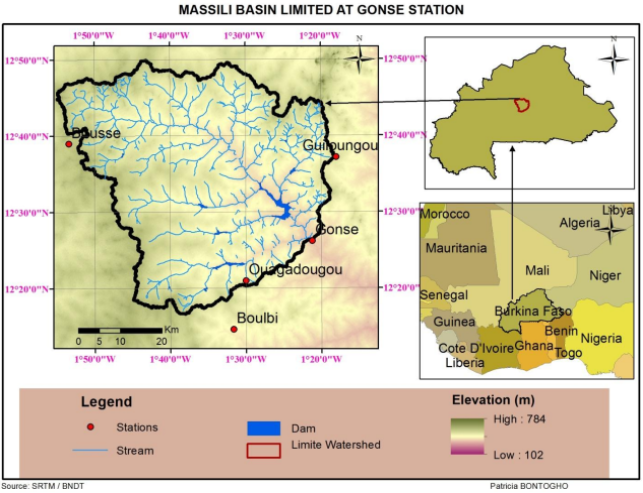
Figure 1. Location of Massili basin limited at Gonse station.
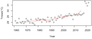
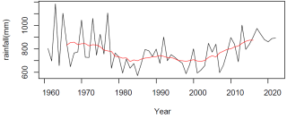
Figure 2. a) annual rainfall variability within Massili Basin (1960-2021); annual mean Temperature variability within Massili basin (1960-2021).
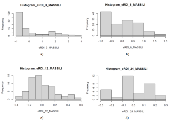
Figure 3. a) Frequency distribution of eRDI at 3 months accumulation; b): Frequency distribution of eRDI at 6 months accumulation; c): Frequency distribution of eRDI at 12 months accumulation; d): Frequency distribution of eRDI at 24 months accumulation.
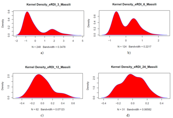
Figure 4. Kernel density for eRDI at various time scale over Massili basin.
Information

