Research Article | | Peer-Reviewed

Physico-chemical Assessment and Environmental Quality of the Waters of Lake Buyo During the Low-water Period of the River Sassandra (South-west Côte d’Ivoire)

Received: 9 July 2025     Accepted: 22 July 2025     Published: 12 August 2025
Views:       Downloads:
Abstract

In Côte d'Ivoire, almost a dozen hydroelectric dams have been built since 1965, with the opening of the Ayamé 1 dam. These dams, in addition to their primary vocation of generating electricity, also serve other functions such as recreation, tourism, flood control and supplying drinking water to local populations. Lake Buyo is a natural resource of considerable interest for the economic development of Côte d'Ivoire. The Buyo dam, built on the Sassandra River in 1980, is no exception. The aim of this study was to assess the water quality of Lake Buyo during low-water periods of the Sassandra River. To do this, water samples and measurements were taken in the lake in March 2021. In situ measurements showed that the waters were warm, with an average temperature of 32.4°C. The waters were alkaline, with fairly low electrical conductivity. These waters were relatively well oxygenated at the surface and deoxygenated at depth during the dry season. On the other hand, the average concentration of suspended solids (SS) was 4.8 mg/L, and the transparency of 1.48 m showed that the the lake’s waters were not very loaded. Based on the nitrate (1.56 mg/L) and ammonium (0.13 mg/L) concentrations, the raw water analyzed complies with the WHO 2017 guidelines for drinking water production, with overall good quality in terms of nitrogen pollution.

Published in Journal of Water Resources and Ocean Science (Volume 14, Issue 4)
DOI 10.11648/j.wros.20251404.12
Page(s) 94-106
Creative Commons

This is an Open Access article, distributed under the terms of the Creative Commons Attribution 4.0 International License (http://creativecommons.org/licenses/by/4.0/), which permits unrestricted use, distribution and reproduction in any medium or format, provided the original work is properly cited.

Copyright

Copyright © The Author(s), 2025. Published by Science Publishing Group

Keywords

Physico-chemical, Assessment, Water Quality, Low-water, Lake Buyo, Dam

1. Introduction
Dams are an essential part of any national water resources management strategy, particularly in countries facing water supply uncertainties, such as those in West Africa.
In fact, hydroelectric dams are built to serve one or more functions, including electricity production, irrigation and water supply. Côte d’Ivoire has a vast hydrographic network with seven (7) major hydroelectric dams (Ayamé 1, Ayamé 2, Kossou, Taabo, Buyo, Fayé and Soubré). However, the reservoirs of these dams, which provide water supply, are increasingly faced with pollution. Indeed, problems linked to water degradation and the proliferation of aquatic plants have been highlighted by several hydrological and physicochemical characterization studies . Furthermore, the transport of sediments and the resulting input of nutrients accelerates the processes of silting, siltation and eutrophication of lakes .
Lake Buyo, the subject of our study, is not immune to the problem of pollution. Despite the dangers inherent in the degradation of the lake's water quality over time, very few hydrological studies have been carried out there. Indeed, the last hydrological studies carried out. Indeed, the last hydrological studies carried out on Lake Buyo date back more than twenty (20) years . This does not allow good monitoring of water quality, knowing that the lake is used to supply water to the region.
It is in this context that the present study has been undertaken. Its aim to determine the characteristics of the physico-chemical parameters of the downstream sector of Lake Buyo in order to assess the quality of the water in the environment during the low-water period of the Sassandra River, to which it is tributary.
2. Materials and Methodes
2.1. Presentation of Study Area
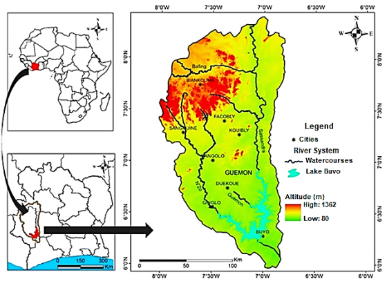
Figure 1. Geographical location of Lake Buyo.
Lake Buyo, the study area, is located in the southwest of Côte d’Ivoire in the town of Buyo. It belongs to the department of Soubré, in the Nawa region, 513 km from Abidjan (economic capital). The lake is located between latitudes 6°10’00” N and 6°20’00” N and longitudes 7°00’0” W and 7°10’0” W with a surface area of 920 km2 (Figure 1). The water reservoir, under investigation is the downstream sector of Lake Buyo. The Buyo zone, corresponding to the reservoir area created by the hydroelectric installations of the Compagnie Ivoirienne d’Electricité (CIE). The lake’s water regime depends on rainfall. Low and high water levels depend essentially on inflows from the Sassandra River and its tributary, the N’zo. Annual rainfall ranges from 1.250 to 1.643 mm.
2.2. Physical-chemical Analysis Equipment
Sampling of physico-chemical parameters was carried out at ten (10) stations during the dry season (March 2021), corresponding to the low-flow period of the Sassandra River. Samplig was carried out on the surface and then in the water column at each station (Figure 2).
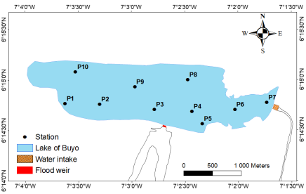
Figure 2. Distribution of sampling points.
The equipment used in the field consisted mainly of a METTLER TOLEDO type multiparameter, a pH meter, a GPS and a Secchi disk. Composed of a probe and a screen, the multiparameter was used for the in-situ measurement of physicochemical parameters (Temperature, Dissolved Oxygen, Conductivity). pH was determined using the pH meter. GPS was used to locate the sampling stations. As for the Secchi disk, was used to measure water transparency.
2.3. Acquisition of Physical-chemical Data
To measure these parameters (pH, Temperature, Dissolved Oxygen, Conductivity, Turbidity) in the field, the multiparameter was calibrated from the boat and then placed in the water at each sampling station. The values obtained were displayed on screen carefully recorded by the operator. To measure transparency, the Secchi disk was lowered into the water using a graduated rope until it disappeared. The height of water above which the disc is no longer visible to the operator is noted in meters (m). Suspended solids (SS) were determined by membrane filtration (Wattman GF/C microfiber). Nutrient salts were determined using a DR 6000 mass spectrometer, plus the HACH 8155 silicate method and the HACH 8171 cadmium reduction method respectively.
Creation of distribution maps
ArcGIS software was used to produce spatial distribution maps for the various physico-chemical parameters. The production of the distribution maps is summarized in two (02) phases. In the first phase, an Excel spreadsheet was used to create a CVS file of numerical data for the various physico-chemical parameters for each station, together with data collected in the field. The Google Earth contour was added to this file. The second phase involved interpolating the spatial distribution maps for the various parameters. The interpolation method used is Inverse Distance Weighted (IDW).
Correlation of physico-chemical parameters by principal component analysis
The data collected during the sampling campaign were subjected to statistical analyses with Statistica 7.1 software for better interpretation of the results. Principal component analysis (PCA), which is an exploratory tool, consisted of looking for linear combinations of quantitative variables with a view to forming factorial axes in order to detect similar individuals, then to highlight a typology of individuals and finally to detect the relationships between the different variables.
Environmental quality assessment
The World Health Organization's drinking water quality guidelines recommend 50 mg/L for nitrates and 0.5 mg/L for ammonium . Nitrate and ammonium levels in the downstream sector of Lake Buyo were compared with the guide values to assess water quality. Ecological status, on the other hand, was assessed against the standards of the European Water Framework Directive (Table 1).
Table 1. Classification according to the of water bodies in .

(mg/l)

Very good

Good

Medium

Poor

Bad

Max. Mineral Nitrogen

< 0.2

0.2 à 0.4

0.4 à 1

1 à 2

> 2

3. Results
3.1. Spatio-temporel Variability and Depth Trends in Physico-chemical Parameters of the Waters of Lake Buyo
i. Lake temperature trends
During low water periods, water temperature ranged from 31.4 to 33.7°C, with an average of 32.4°C ± 0.76 (Figure 3). High values (32.6 - 33.7°C) covered practically ¾ of the lake surface. The low values (31.4 - 32.5°C) were located to the east of the reservoir on the water intake side. The thematic map showed a negative West-East horizontal gradient. However, the temperature variation in depth showed a negative surface-bottom gradient (Figure 4).
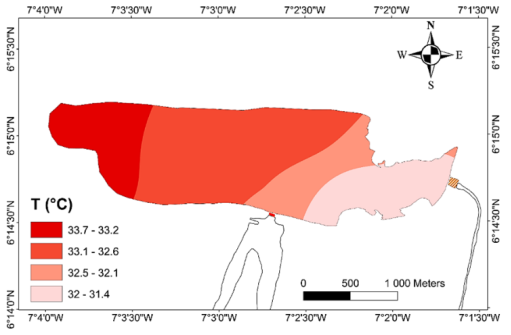
Figure 3. Spatial distribution of temperature in Lake Buyo during low water periods.
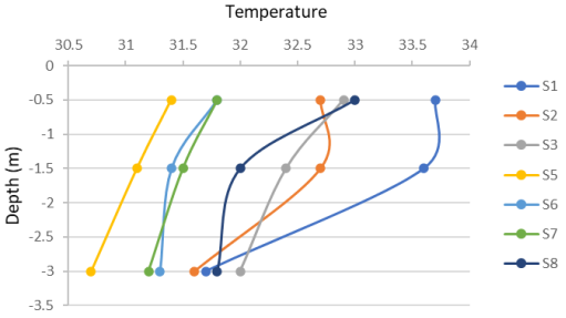
Figure 4. Temperature trends in the water column of Lake Buyo during low-water periods.
ii. Evolution of lake pH
The water of the downstream sector of Lake Buyo was alkaline, with basicity increasing from north to south. pH values ranged from 7.9 to 9.78, with an average of 8.61 ± 0.55. The highest pH values (9.1-9.78) were found in the area around the spillway (Figure 5). The pH values measured at the surface were more basic than those measured at the bottom (Figure 6).
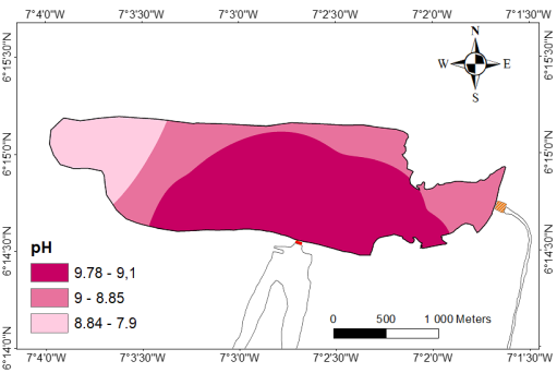
Figure 5. Spatial distribution of surface water pH during low-water periods.
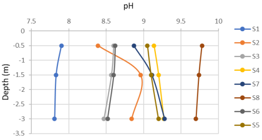
Figure 6. Evolution of pH in the water column of Lake Buyo during low-water periods.
iii. Distribution of lake water conductivity
During low-water periods, conductivity values ranged from 60 µS/cm to 80 µS/cm, with an average of 67.5 µS/cm ± 7.07 (Figure 7). The highest conductivity values were recorded to the west of the water body, and the lowest on the side of the flood spillway. Conductivity levels tended to increase with depth, averaging of 83.68 µS/cm ± 10.75 (Figure 8).
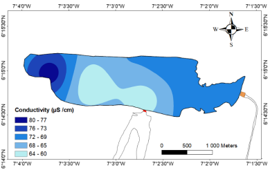
Figure 7. Spatial distribution of surface water conductivity during low-water periods.
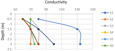
Figure 8. Evolution of conductivity in the water column of Lake Buyo duriing low-water periods.
iv. Distribution of dissolved oxygen content of lake waters
The spatial evolution of dissolved oxygen during low-water periods shows that the dissolved oxygen content varied between 5 and 7 mg/L, with an average of 5.5 mg/L ± 0.75 (Figure 9). High levels (6 and 7 mg/L) were found to the southwest of the lake and at the water intake. Low levels of dissolved O2 (5-5.4 mg/L), which were more dominant, were located in the vertical axis of the spillway. Figure 10 showed an overall decrease in dissolved oxygen with depth during low-water periods, reaching its lowest value at station 3 (5 to 1 mg/L).
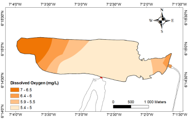
Figure 9. Spatial distribution of dissolved oxygen in surface water during low flow periods.
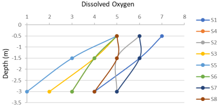
Figure 10. Variation in the dissolved oxygen content in the water column of Lake Buyo during low flow periods.
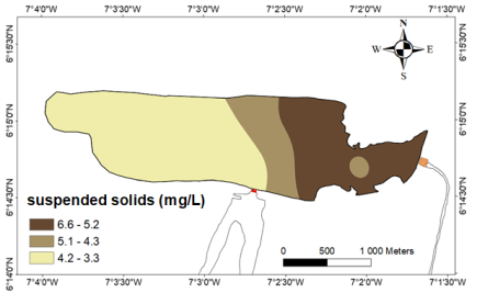
Figure 11. Spatial distribution of SS from surface waters during low-water periods.
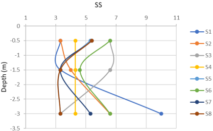
Figure 12. Variation of SS in the water column of Lake Buyo during low-water periods.
v. Distribution of suspended solids (SS) in lake water
The dry-season suspended solids distribution map showed a heterogeneous distribution. Total suspended solids concentrations varied from 3.3 to 6.6 mg/L, with an average of 5.025 mg/L ± 1.30 (Figure 11). Transparency values ranged from 1.3 m to 1.7 m, with an average of 1.48 m. However, the SS concentration generally decreased with depth (Figure 12).
vi. Distribution of ammoniacal nitrogen in lake waters
Spatial variation during low-water periods highlighted the predominance of contents between 0.16 mg/L and 0.17 mg/L. Ammonium levels ranged between 0.07 mg/L to 0.17 mg/L, with an average of 0.127 mg/L ± 0.03. Low levels (0.07-0.11 mg/L) were found to the east of the reservoir, near the water intake, while high levels were found to the west, near the flood spillway (Figure 13). Analysis of the profiles highlights a decrease in ammonium with depth. However, there was a clear increase in NH4+ content at stations 5 and 8 (Figure 14).
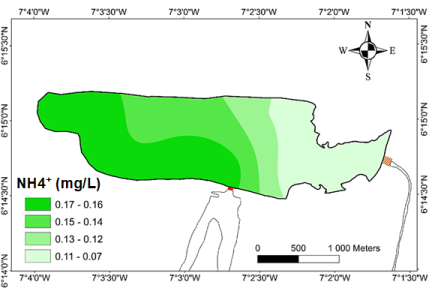
Figure 13. Spatial distribution of ammonium NH4+ during low-low periods.
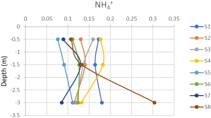
Figure 14. Variation in the ammonium content in the water column of Lake Buyo during low-water periods.
vii. Distribution of nitrates in lake water
At low water, NO3- contents oscillated between 0.401 mg/L and 1.9 mg/L, with an average of 0.975 mg/L ± 0.47 (Figure 15). The highest levels (1.61-1.9 mg/L) were found to the south, on the spillway side, and to the east, at the water intake. Analysis of the profiles shows an increase in the NO3- content from the surface to a depth of 1.5 m, and a gradual decrease to a depth of 3 m (Figure 16).
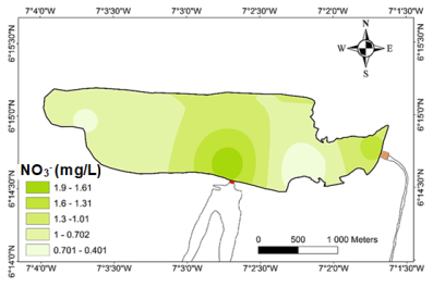
Figure 15. Spatial distribution of NO3- nitrates during low-water periods.
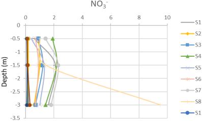
Figure 16. Variation in nitrate content in the water column of Lake Buyo during low-water periods.
3.2. Statistical Analysis of Physico-chemical Data from the Lake's Surface Waters
i. Correlation matrix
Table 2 presents the correlation matrix showing the relationships between the physicochemical variables taken two by two. On analysis, it emerges that:
A good correlation (r= 0.74) between temperature and ammonium;
A positive mean correlation (r= 0.50) between temperature and dissolved oxygen;
A positive mean correlation (r= 0.53) between dissolved oxygen and conductivity;
A good negative correlation (r= - 0.71) between pH and dissolved oxygen;
A good negative correlation (r= - 0.70) between dissolved oxygen and SS;
A negative mean correlation (r= - 0.50) between temperature and SS;
A negative mean correlation (r= - 0.50) between conductivity and nitrate.
Table 2. Correlation matrix.

Matrice

pH

O2

Cd

NH4

NO3

SS

1.00

pH

-0.32

1.00

O2

0.50

-0.71

1.00

Cd

0.15

-0.23

0.53

1.00

NH4

0.74

-0.42

0.26

-0.20

1.00

NO3

0.02

0.35

-0.16

-0.50

0.34

1.00

SS

-0.50

0.37

-0.70

-0.13

-0.37

-0.10

1.00

*T°: temperature, Cd: conductivity, NH4: ammonium, NO3: nitrates, O2: dissolved oxygen, pH: hydrogen potential, SS: suspended solids.
ii. Principal component analysis of variables
Table 3 shows the percentage of variance expressed by each factor. Analysis of this table shows that the first two factorial axes account for 43.54% and 26.85% respectively of the variance expressed. These factors express 70.39% of the cumulative variance. Given these percentages, these factors (Fact. 1 and Fact. 2) alone provide over 70% of the statistical information. For this reason, PCA is right take only two factors into account when analysing factorial designs. Representation using the first two factors gives a satisfactory account of the structure of the cloud of points.
Table 3. Eigen values and percentages of variances expressed by the factors.

F1

F2

F3

F4

F5

F6

F7

Own values

3.05

1.88

0.81

0.68

0.42

0.16

0.00

%Variance expressed

43.54

26.85

11.54

9.68

6.01

2.34

0.04

%Cumulative variance

43.54

70.39

81.93

91.61

97.62

99.96

100.00

iii. Projection into variable space
The projection of the variables onto the plane formed by the first two factors (F1 and F2) during the low-water period is illustrated by Figure 17.
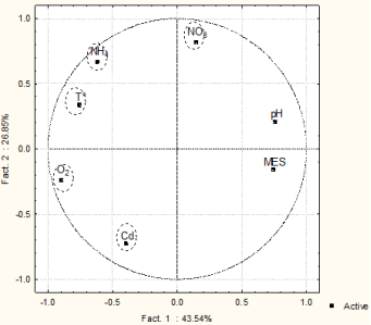
Figure 17. Community circle of the F1-F2 factorial plan for the downstream sector of Lake Buyo during low-water periods.
Temperature, dissolved O2 and ammonium, on the other hand, are defined on the negative side of this axis. Factor 1 therefore reflects a gradient of organic matter decomposition by cyanobacteria.
The positive part of the Factor 2 is determined by NO3-and NH4+, while the negative part is determined by conductivity. Factor 2 reflects an increasing gradient water nitrification.
Figure 18 distinguishes three (3) families of stations: GI, GII and GIII. Group I is represented by station 1, located to the southwest of the reservoir. It is characterized by a fairly low pH, high dissolved oxygen levels and strong mineralization. Group II comprises stations 2, 3 and 4. These waters are low in suspended matter and conductivity. Group III, comprising stations 5, 6, 7 and 8, is characterized by waters with a high suspended solids content and moderate mineralization.
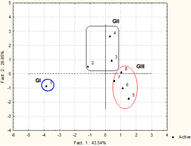
Figure 18. Representation of the stations in the F1-F2 factorial plan of the waters of the downstream sector of Lake Buyo during low-water periods.
3.3. Environmental Quality of Lake Water
Quality of “drinking water”
Ammonium (NH4+) and nitrate (NO3-) contents of the waters in the downstream sector of Lake Buyo were used to assess the water quality. Average values during low-water periods were 1.56 mg/L ± 0.59 for NO3- and 0.13 mg/L ± 0.009 for NH4+ in Lake Buyo. Considering the results, these waters are of good quality for consumption during low-water periods.
The value of mineral nitrogen (ammonium and nitrates) in the surface waters of Lake Buyo during low-water periods is 1.10 mg/L. The lake’s water quality is therefore mediocre during low-water periods.
4. Discussion
Analysis of surface hydrogen potential showed that pH values vary in the downstream sector of Lake Buyo from 7.81 to 9.78, with an average of 8.67 during low- water periods. The pH values obtained are more or less close to those measured on Lake Bacon which varies from 6.5 to 9.5 . Taking into account the observation period, the average dissolved oxygen content of the surface waters of Lake Buyo is 5.5 mg/L. This result is consistent with those obtained by on Lake Buyo (5.7 mg/L). DO concentrations in Lake Buyo show that the surface waters are more oxygenated than bottom waters. The high oxygen contents, recorded in the superficial zones, are due to photosynthetic activities which generally occur with greater intensity in these zones due to the high light penetration. In deeper zones, on the other hand, the oxidation of organic matter leads to deoxygenation of the water. These same observations were made by , in Taabo and Buyo lakes respectively. The temperature values observed indicate that the waters are warmer during low- water periods (32.47°C). Temperatures of Lake Buyo vary little and are substantially identical to those obtained (27.48°C to 32.45°C) by on Lake M’bakré and those of (26°C to 32°C) on Lake Buyo. Furthermore, temperature changes with depth reveal thermal stratification. This occurs when depth permits and has repercussions on dissolved oxygen concentrations and pH values.
The average conductivity of surface water in the downstream sector of Lake Buyo during low-water periods is 67.5 µS/cm. Lake Buyo therefore has very low electrical conductivity (EC less than 100 µS/cm). Conductivity values during this dry season are in line with those obtained by on Lake Taabo (83 µS/cm). This is explained by the drop in input flows due to runoff. Analysis of SS in Lake Buyo shows that the waters are very lightly loaded during low- water periods (4.81 mg/L). reports that the importance and nature of the suspended solid flow are linked to the intensity of erosion by runoff water, and therefore to the amount of rainfall.
The levels of nutrient salts (ammonium and nitrates) in the downstream sector of Lake Buyo are relatively low. These results are consistent with those of . According to , these low nutrient levels in the Buyo zone, in particular, could be the result of photosynthetic activity due to phytoplankton rather than macrophytes. Ammonium and nitrate concentrations compared to the guide values show that the water is of good quality for consumption at low water levels.
5. Conclusions
The waters in the downstream sector of Lake Buyo are alkaline, weakly mineralized, relatively well oxygenated at the surface and deoxygenated at depth. SS concentrations vary with depth during the low-water period and generally show a negative vertical gradient. This variation may reflect surface current phenomena in the lake. The average value during low-water periods is 1.56 mg/L ± 0.59 for NO3- and 0.13 mg/L ± 0.009 for NH4+ in Lake Buyo. The ammonium and nitrate value comply with the WHO guideline for drinking water. In addition, the waters in the downstream sector of Lake Buyo are poor during the low-water period. The use of multivariate techniques (ACPN) enables us to highlight the decomposition of organic matter by cyanobacteria, nitrification and natural mineralization of the lake.
Abbreviations

WFD

Water Framework Directive

ME

Body Mass Index

DO

Dissolved Oxygen

SS

Solid Suspension

NPCA

Normal Principal Component Analysis

PCA

Principal Component Analysis

WHO

World Health Organisation

MEEDDAT

Ministry of Ecology, Energy, Sustainable Development and Territory Planning

IDW

Inverse Distance Weighted

GPS

Global Positioning System

CIE

Compagnie Ivoirienne d’Electricité

Acknowledgments
The authors would like to thank the “Compagnie Ivoirienne d’Electricité (CIE)” for authorizing access to the Buyo hydroelectric dam lake.
Author Contributions
Ronald Sosthène Désiré Yapi Atto: Conceptualization, Formal Analysis, Funding acquisition, Project administration, Supervision, Writing – original draft
Kouadio Assemien François Yao: Formal Analysis, Project administration, Supervision
Guy Serges Konan: Formal Analysis, Funding acquisition, Project administration, Supervision
Sylvain Monde: Supervision
Funding
This work is not supported by any external funding.
Data Availability Statement
The data supporting the outcome of this research work has been reported in this manuscript.
Conflicts of Interest
The authors declare no conflicts of interest.
References
[1] Mambo, V., Jidon, A., Yapo, O. and Houenou, P. (2001). Assessment of the trophic state of Lake Buyo (CI): physicochemical and biological aspects, J. Soc. West-Afr. Chem. Flight. 11, pp. 95-134.
[2] Yapo, O. (2003). Contribution to the evaluation of the trophic state of Lake Buyo (Southwest of Ivory Coast): Analytical and statistical study of physicochemical and biological parameters. Unique doctoral thesis in Environmental Sciences and Management, University of Abobo-Adjamé (Ivory Coast), 279 p.
[3] Groga, N. (2012). Structure, functioning and dynamics of phytoplankton in Lake Taabo (Ivory Coast). Doctoral thesis, University of Toulouse, p. 224.
[4] Atto, Y. D. S. (2018). Characterization of pollution and evolution of the morphology of the bottom of water reservoirs developed for the supply of drinking water: case of the Adaou and Bacon reservoirs (Eastern Ivory Coast). Doctoral thesis, Félix Houphouët Boigny University, Abidjan, 188 p.
[5] N’go, Y. A. (2000). Contribution to the study of soil erosion in the Sassandra watershed (Buyo region): Analysis of factors and risk assessment test by remote sensing and geographic information systems. Postgraduate doctoral thesis, University of Abobo-Adjamé (Ivory Coast), (Hydrob. and GIS), 164 p.
[6] WHO. (2017). Guidelines for drinking water quality. 4th ed. incorporating first addendum. World Health Organization, Switzerland; p. 564. ISBN 978-92-4-254995-9.
[7] Directive 2000/60/ec of the european parliament and of the council. (2000). Framework for a Community policy in the field of water. 72 p.
[8] Meeddat (ministry of ecology, energy, sustainable development and territory planning). (2009). Assessment of the state of fresh surface water in the metropolis. Technical Guide, Paris, 73 p.
[9] Kouassi, K. L. (2007). Hydrology, solid transport and modeling of sedimentation in the lakes of hydroelectric dams in Côte d'Ivoire: case of Lake Taabo. Doctoral thesis, University of Abobo-Adjamé, 209 p.
[10] Aka, C. (2016). Bathymetric, hydrological and sedimentological characterization of a lake environment on the coast of Ivory Coast: case of Lake M'bakré. Doctoral thesis. Felix Houphouët Boigny University, 176 p.
[11] Bouanani, A. (2004). Hydrology, solid transport and modeling: study of some Tafna sub-basins (NW – Algeria). State Doctorate Thesis, University of Abou Bekr Belkaid Tlemcen, 249 p.
Cite This Article
  • APA Style

    Atto, R. S. D. Y., Yao, K. A. F., Konan, G. S., Monde, S. (2025). Physico-chemical Assessment and Environmental Quality of the Waters of Lake Buyo During the Low-water Period of the River Sassandra (South-west Côte d’Ivoire). Journal of Water Resources and Ocean Science, 14(4), 94-106. https://doi.org/10.11648/j.wros.20251404.12

    Copy | Download

    ACS Style

    Atto, R. S. D. Y.; Yao, K. A. F.; Konan, G. S.; Monde, S. Physico-chemical Assessment and Environmental Quality of the Waters of Lake Buyo During the Low-water Period of the River Sassandra (South-west Côte d’Ivoire). J. Water Resour. Ocean Sci. 2025, 14(4), 94-106. doi: 10.11648/j.wros.20251404.12

    Copy | Download

    AMA Style

    Atto RSDY, Yao KAF, Konan GS, Monde S. Physico-chemical Assessment and Environmental Quality of the Waters of Lake Buyo During the Low-water Period of the River Sassandra (South-west Côte d’Ivoire). J Water Resour Ocean Sci. 2025;14(4):94-106. doi: 10.11648/j.wros.20251404.12

    Copy | Download

  • @article{10.11648/j.wros.20251404.12,
      author = {Ronald Sosthène Désiré Yapi Atto and Kouadio Assemien François Yao and Guy Serges Konan and Sylvain Monde},
      title = {Physico-chemical Assessment and Environmental Quality of the Waters of Lake Buyo During the Low-water Period of the River Sassandra (South-west Côte d’Ivoire)
    },
      journal = {Journal of Water Resources and Ocean Science},
      volume = {14},
      number = {4},
      pages = {94-106},
      doi = {10.11648/j.wros.20251404.12},
      url = {https://doi.org/10.11648/j.wros.20251404.12},
      eprint = {https://article.sciencepublishinggroup.com/pdf/10.11648.j.wros.20251404.12},
      abstract = {In Côte d'Ivoire, almost a dozen hydroelectric dams have been built since 1965, with the opening of the Ayamé 1 dam. These dams, in addition to their primary vocation of generating electricity, also serve other functions such as recreation, tourism, flood control and supplying drinking water to local populations. Lake Buyo is a natural resource of considerable interest for the economic development of Côte d'Ivoire. The Buyo dam, built on the Sassandra River in 1980, is no exception. The aim of this study was to assess the water quality of Lake Buyo during low-water periods of the Sassandra River. To do this, water samples and measurements were taken in the lake in March 2021. In situ measurements showed that the waters were warm, with an average temperature of 32.4°C. The waters were alkaline, with fairly low electrical conductivity. These waters were relatively well oxygenated at the surface and deoxygenated at depth during the dry season. On the other hand, the average concentration of suspended solids (SS) was 4.8 mg/L, and the transparency of 1.48 m showed that the the lake’s waters were not very loaded. Based on the nitrate (1.56 mg/L) and ammonium (0.13 mg/L) concentrations, the raw water analyzed complies with the WHO 2017 guidelines for drinking water production, with overall good quality in terms of nitrogen pollution.},
     year = {2025}
    }
    

    Copy | Download

  • TY  - JOUR
    T1  - Physico-chemical Assessment and Environmental Quality of the Waters of Lake Buyo During the Low-water Period of the River Sassandra (South-west Côte d’Ivoire)
    
    AU  - Ronald Sosthène Désiré Yapi Atto
    AU  - Kouadio Assemien François Yao
    AU  - Guy Serges Konan
    AU  - Sylvain Monde
    Y1  - 2025/08/12
    PY  - 2025
    N1  - https://doi.org/10.11648/j.wros.20251404.12
    DO  - 10.11648/j.wros.20251404.12
    T2  - Journal of Water Resources and Ocean Science
    JF  - Journal of Water Resources and Ocean Science
    JO  - Journal of Water Resources and Ocean Science
    SP  - 94
    EP  - 106
    PB  - Science Publishing Group
    SN  - 2328-7993
    UR  - https://doi.org/10.11648/j.wros.20251404.12
    AB  - In Côte d'Ivoire, almost a dozen hydroelectric dams have been built since 1965, with the opening of the Ayamé 1 dam. These dams, in addition to their primary vocation of generating electricity, also serve other functions such as recreation, tourism, flood control and supplying drinking water to local populations. Lake Buyo is a natural resource of considerable interest for the economic development of Côte d'Ivoire. The Buyo dam, built on the Sassandra River in 1980, is no exception. The aim of this study was to assess the water quality of Lake Buyo during low-water periods of the Sassandra River. To do this, water samples and measurements were taken in the lake in March 2021. In situ measurements showed that the waters were warm, with an average temperature of 32.4°C. The waters were alkaline, with fairly low electrical conductivity. These waters were relatively well oxygenated at the surface and deoxygenated at depth during the dry season. On the other hand, the average concentration of suspended solids (SS) was 4.8 mg/L, and the transparency of 1.48 m showed that the the lake’s waters were not very loaded. Based on the nitrate (1.56 mg/L) and ammonium (0.13 mg/L) concentrations, the raw water analyzed complies with the WHO 2017 guidelines for drinking water production, with overall good quality in terms of nitrogen pollution.
    VL  - 14
    IS  - 4
    ER  - 

    Copy | Download

Author Information
  • Mines and Reservoirs Department, University of Man, Man, Côte d’Ivoire

    Biography: Ronald Sosthène Désiré Yapi Atto is an Assistant Professor at the University of Man, Côte d’Ivoire, Geological and Mining Sciences Teaching and Research Unit. He completed his PhD in geology and sedimentology from the University of Felix houphouet Boigny (Côte d'Ivoire) in 2018, and his Master’s degree of Geology marine and sedimentology from Félix Houphouët-Boigny University (Côte d’Ivoire) in 2014. He has participated in several international conferences. Dr. ATTO is currently deputy Director of the school of mines and energy at the University of Man. His research interests include hydro-sedimentology, hydrosedimentary modelling, water quality, environmental assessment and remote sensing. He is a member of the Côte d'Ivoire National PHI Committee and a member of the Geological Society of AFRICA.

    Research Fields: hydro-sedimentology, hydro-sedimentary modelling, water quality, environmental assessment, Oceanology, reservoir petrophysics and remote sensing

  • Mines and Reservoirs Department, University of Man, Man, Côte d’Ivoire

    Biography: Kouadio Assemien François Yao is an Assistant Professor at the University of Man, Côte d’Ivoire, Geological and Mining Sciences Teaching and Research Unit. He completed his PhD in Hydrogeology and environmental assessment from the University of Montpellier (France) in 2018, and his Master’s degree of Hydrogeology from Félix Houphouët-Boigny University (Côte d’Ivoire) in 2014. He has participated in several international conferences. Dr. YAO currently holds the position of Head of the Department of Geology and Materials at the University of Man. His research focuses on Geochemistry, Water quality, Climate change, Hydrogeology Modelling, and Environmental assessment.

    Research Fields: Geochemistry, Water quality, Climate change, Hydrogeology Modelling, and Environmental assessment

  • Laboratory of Geology, Mineral and Energy Resources, Félix Houphouët-Boigny University, Abidjan, Côte d’Ivoire

    Biography: Guy Serges Konan is a PhD in marine geology from the Université Félix Houphouët-Boigny (2023), specialising in hydrosedimentary modelling applied to dam lakes. He obtained a master's degree in marine geology in 2018, and his work focuses on the morphobathymetric and sedimentological characterisation of lake environments. He has taken part in several major projects in Côte d'Ivoire, including the hydrosedimentary study of the Soubré dam lake and the analysis of the water bodies surrounding the Ehotilés Islands as part of their World Heritage listing. He also carried out a doctoral internship in Switzerland, working for HydroExploitation SA, on the silting up of Lake Dix (Grande Dixence dam). His current research incorporates digital tools, hydrospatial analysis and modelling for the sustainable management of aquatic environments. He is a member of the International Association of Sedimentologists (IAS).

    Research Fields: digital tools, hydrospatial analysis and modelling for the sustainable management of aquatic environments

  • Laboratory of Geology, Mineral and Energy Resources, Félix Houphouët-Boigny University, Abidjan, Côte d’Ivoire

    Biography: Sylvain Monde is a Full Professor of Geosciences at Félix Houphouët-Boigny University (UFHB), Côte d’Ivoire, where he currently serves as Head of the Department of Geosciences. He holds two Ph.D. degrees: one from UFHB and another from La Rochelle University (France), complemented by postdoctoral research in oceanography at Québec University (Canada). Professor MONDE’s research spans marine geology, sedimentology, coastal dynamics, and hydrosedimentary modeling. He has authored over 130 scientific publications and supervised numerous doctoral and master’s theses. His work has contributed to national and international projects, including oceanographic missions and environmental assessments. He is actively involved in scientific networks such as the Interna-tional Association of Sedimentologists and the Order of Geologists of Quebec. Beyond academia, he serves as a municipal councilor in Azaguié and Vice-President of the Commission for Social and Cultural Affairs. His career reflects a strong commitment to scientific excellence and sustainable development in Africa.

    Research Fields: marine geology, sedimentology, coastal dynamics, and hydrosedimentary modeling